


<< Our Photo Pages >> Whitecairn (Boreland) - Cairn in Scotland in Dumfries and Galloway
Submitted by PaulM on Thursday, 02 January 2003 Page Views: 4128
Neolithic and Bronze AgeSite Name: Whitecairn (Boreland) Alternative Name: White CairnCountry: Scotland County: Dumfries and Galloway Type: Cairn
Nearest Town: Wigtown Nearest Village: Causeway End
Map Ref: NX35285819 Landranger Map Number: 83
Latitude: 54.891224N Longitude: 4.569816W
Condition:
| 5 | Perfect |
| 4 | Almost Perfect |
| 3 | Reasonable but with some damage |
| 2 | Ruined but still recognisable as an ancient site |
| 1 | Pretty much destroyed, possibly visible as crop marks |
| 0 | No data. |
| -1 | Completely destroyed |
| 5 | Superb |
| 4 | Good |
| 3 | Ordinary |
| 2 | Not Good |
| 1 | Awful |
| 0 | No data. |
| 5 | Can be driven to, probably with disabled access |
| 4 | Short walk on a footpath |
| 3 | Requiring a bit more of a walk |
| 2 | A long walk |
| 1 | In the middle of nowhere, a nightmare to find |
| 0 | No data. |
| 5 | co-ordinates taken by GPS or official recorded co-ordinates |
| 4 | co-ordinates scaled from a detailed map |
| 3 | co-ordinates scaled from a bad map |
| 2 | co-ordinates of the nearest village |
| 1 | co-ordinates of the nearest town |
| 0 | no data |
Internal Links:
External Links:
 (PID:2214)")
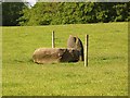
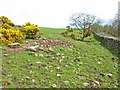
Located in the same field as the Knocknocher stone pair this cairn is marked on the map as 'White Cairn'.
For more information see Canmore ID 62849 which records: "A much-robbed grass-covered cairn measuring 36.0m in diameter and 2.2m in maximum height" and adds that the cairn has been considerably quarried for stones from the top but has never been excavated.
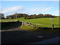
Note: Please note this site is on private land so permission should be sought before visiting.
You may be viewing yesterday's version of this page. To see the most up to date information please register for a free account.
 (PID:209893)")
 (PID:209892)")
Do not use the above information on other web sites or publications without permission of the contributor.
Nearby Images from Geograph Britain and Ireland:
©2007(licence)
©2007(licence)
©2010(licence)
©2010(licence)
©2010(licence)
The above images may not be of the site on this page, they are loaded from Geograph.
Please Submit an Image of this site or go out and take one for us!
Click here to see more info for this site
Nearby sites
Key: Red: member's photo, Blue: 3rd party photo, Yellow: other image, Green: no photo - please go there and take one, Grey: site destroyed
Download sites to:
KML (Google Earth)
GPX (GPS waypoints)
CSV (Garmin/Navman)
CSV (Excel)
To unlock full downloads you need to sign up as a Contributory Member. Otherwise downloads are limited to 50 sites.
Turn off the page maps and other distractions
Nearby sites listing. In the following links * = Image available
125m SSW 206° Knocknocher stone pair* Standing Stones (NX35225808)
406m ESE 116° Spittal Croft cairn* Cairn (NX35645800)
2.7km SSE 150° White Cairn (Crouse)* Cairn (NX36585577)
2.8km SSE 150° Crow Stone (Wigtown)* Standing Stone (Menhir) (NX3658555732)
3.0km ESE 117° Torhousekie Farm Cairn* Cairn (NX37895676)
3.3km ESE 116° Torhouse North Side Cairn* Cairn (NX3817456665)
3.3km ESE 117° Torhousekie N* Cairn (NX38195660)
3.4km ESE 115° Torhouse North Cairn* Cairn (NX3828156679)
3.4km ESE 119° Torhouseskie South West Standing Stones* Standing Stones (NX38205644)
3.4km ESE 118° Torhousekie stone circle* Stone Circle (NX3825556493)
3.4km ESE 118° Torhousekie Stones East* Standing Stones (NX3827156468)
3.5km ESE 116° Torhousekie East* Stone Row / Alignment (NX38385651)
3.8km ESE 122° Torhousekie Standing Stone* Standing Stone (Menhir) (NX3843456097)
4.4km NE 40° Cairn Hill (Barraer)* Cairn (NX38226149)
4.5km NNW 338° Barhoise* Cairn (NX33776245)
4.8km NNW 340° Shennanton SE* Cairn (NX33816280)
5.2km NNW 338° Shennanton NW* Cairn (NX33546310)
5.8km SSE 156° Culmalzie (Whauphill) Holy Well or Sacred Spring (NX37405281)
5.8km N 8° Cairn Wood (Barskeoch)* Cairn (NX36266391)
5.9km E 90° Cairnhouse W* Cairn (NX41205798)
6.5km E 88° Cairnhouse E* Cairn (NX41765813)
6.7km SE 145° Barvernochan Standing Stone* Standing Stone (Menhir) (NX38975255)
7.0km ENE 58° High Baltersan* Cairn (NX41346168)
7.2km ESE 114° Neilson's Hill* Rock Art (NX4176655018)
7.5km WSW 239° Castle Loch* Cairn (NX28695460)
View more nearby sites and additional images


 We would like to know more about this location. Please feel free to add a brief description and any relevant information in your own language.
 Wir möchten mehr über diese Stätte erfahren. Bitte zögern Sie nicht, eine kurze Beschreibung und relevante Informationen in Deutsch hinzuzufügen.
 Nous aimerions en savoir encore un peu sur les lieux. S'il vous plaît n'hesitez pas à ajouter une courte description et tous les renseignements pertinents dans votre propre langue.
 Quisieramos informarnos un poco más de las lugares. No dude en añadir una breve descripción y otros datos relevantes en su propio idioma.