


<< Our Photo Pages >> Lyonston Stone - Standing Stone (Menhir) in Scotland in South Ayrshire
Submitted by markj99 on Saturday, 29 June 2019 Page Views: 1804
Neolithic and Bronze AgeSite Name: Lyonston Stone Alternative Name: MayboleCountry: Scotland County: South Ayrshire Type: Standing Stone (Menhir)
Nearest Town: Maybole
Map Ref: NS30991039
Latitude: 55.358356N Longitude: 4.667703W
Condition:
| 5 | Perfect |
| 4 | Almost Perfect |
| 3 | Reasonable but with some damage |
| 2 | Ruined but still recognisable as an ancient site |
| 1 | Pretty much destroyed, possibly visible as crop marks |
| 0 | No data. |
| -1 | Completely destroyed |
| 5 | Superb |
| 4 | Good |
| 3 | Ordinary |
| 2 | Not Good |
| 1 | Awful |
| 0 | No data. |
| 5 | Can be driven to, probably with disabled access |
| 4 | Short walk on a footpath |
| 3 | Requiring a bit more of a walk |
| 2 | A long walk |
| 1 | In the middle of nowhere, a nightmare to find |
| 0 | No data. |
| 5 | co-ordinates taken by GPS or official recorded co-ordinates |
| 4 | co-ordinates scaled from a detailed map |
| 3 | co-ordinates scaled from a bad map |
| 2 | co-ordinates of the nearest village |
| 1 | co-ordinates of the nearest town |
| 0 | no data |
Internal Links:
External Links:
I have visited· I would like to visit
markj99 visited on 28th Nov 2023 - their rating: Cond: 4 Amb: 3 Access: 4 I took the opportunity to revisit Lyonston Stone while travelling through Maybole. I normally take the Maybole bypass to and from Ayr. Take the Kirkmichael Road at the E edge of Maybole. After a quarter of a mile there lay-by on the right side of the road. Walk 25 yards back towards Maybole to the iron stile into the field on your right. Follow the wall for 75 yards to the iron stile at which point you can see the stone left of you in the next field.
")
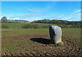
Lyonston Stone lies in a field of Lyonston farm on the eastern edge of Maybole between the A77 and Kirkmichael Road. It is a substantial standing stone, 4 feet high and squat. It is listed as prehistoric under Canmore ID 41670, a 1895 source saying: "There is a standing stone of grey granite, 4ft high by 3ft 4ins by 2ft 7ins on the summit of rising ground on Lyonstone. It is larger at the top, and very much rounded at the angles".
To find this standing stone, take the Kirkmichael Road at the E edge of Maybole. After a quarter of a mile there lay-by on the right side of the road. Walk 25 yards back towards Maybole to the iron stile into the field on your right. Follow the hedge for 150 yards to the iron stile at which point you can see the stone left of you in the next field.
You may be viewing yesterday's version of this page. To see the most up to date information please register for a free account.
")
Do not use the above information on other web sites or publications without permission of the contributor.
Nearby Images from Geograph Britain and Ireland:
©2013(licence)

©2014(licence)
©2010(licence)
©2010(licence)
©2012(licence)
The above images may not be of the site on this page, they are loaded from Geograph.
Please Submit an Image of this site or go out and take one for us!
Click here to see more info for this site
Nearby sites
Key: Red: member's photo, Blue: 3rd party photo, Yellow: other image, Green: no photo - please go there and take one, Grey: site destroyed
Download sites to:
KML (Google Earth)
GPX (GPS waypoints)
CSV (Garmin/Navman)
CSV (Excel)
To unlock full downloads you need to sign up as a Contributory Member. Otherwise downloads are limited to 50 sites.
Turn off the page maps and other distractions
Nearby sites listing. In the following links * = Image available
3.2km SSW 198° Kildoon Hillfort* Hillfort (NS29860738)
3.6km WNW 291° Howmoor* Stone Fort or Dun (NS2770711809)
5.3km W 276° Balchriston* Stone Fort or Dun (NS2572911176)
6.6km NNE 18° Wallace's Stone (Blairstone Mains)* Early Christian Sculptured Stone (NS3321416579)
6.9km NE 54° Barbieston Farm cist* Cist (NS36751417)
7.3km SSW 198° Captain's Bridge (Drummochreen) W* Hillfort (NS28510356)
7.3km SSW 197° Captain's Bridge (Drummochreen) SE* Stone Fort or Dun (NS28530351)
8.1km SW 217° East Threave* Cairn (NS25870411)
8.4km N 7° Stonefield Park, Ayr* Standing Stone (Menhir) (NS32271869)
9.2km SSW 205° Cairn Hill (Dalquharran)* Cairn (NS26690219)
9.6km WSW 249° Shanter Knowe* Artificial Mound (NS21890738)
10.4km SSE 160° Knockinculloch* Ancient Village or Settlement (NS34200050)
10.5km WSW 253° Bains Hill* Standing Stone (Menhir) (NS20750773)
12.5km SSW 202° Maxwelstone Camp* Hillfort (NX25959895)
14.9km NNE 12° Bruce's Well (Prestwick)* Holy Well or Sacred Spring (NS3467624801)
15.6km SE 141° Cairnwhapple Stone* Natural Stone / Erratic / Other Natural Feature (NX40399796)
16.2km SSE 168° Bencallen Hill* Chambered Cairn (NX33779440)
18.0km NNE 13° The Muckle Stane (Monkton)* Natural Stone / Erratic / Other Natural Feature (NS3578027790)
20.4km SSW 210° Dinvin Earthworks* Misc. Earthwork (NX2002993173)
20.5km NNE 34° Tarbolton Cist* Cist (NS4327)
20.8km SE 145° Moss Knowes* Natural Stone / Erratic / Other Natural Feature (NX42239281)
20.9km NE 39° Coilsfield (Tarbolton) Rock Art (NS44692624)
20.9km NE 39° Tarbolton Tumulus Cairn (NS4469926247)
22.0km ESE 114° Cairnennock Cairn (NS50800078)
22.0km E 91° Beoch Stone Circle Stone Circle (NS530090)
View more nearby sites and additional images


 We would like to know more about this location. Please feel free to add a brief description and any relevant information in your own language.
 Wir möchten mehr über diese Stätte erfahren. Bitte zögern Sie nicht, eine kurze Beschreibung und relevante Informationen in Deutsch hinzuzufügen.
 Nous aimerions en savoir encore un peu sur les lieux. S'il vous plaît n'hesitez pas à ajouter une courte description et tous les renseignements pertinents dans votre propre langue.
 Quisieramos informarnos un poco más de las lugares. No dude en añadir una breve descripción y otros datos relevantes en su propio idioma.