


<< Our Photo Pages >> Minions Round Cairns - Round Cairn in England in Cornwall
Submitted by coldrum on Wednesday, 14 October 2009 Page Views: 3627
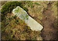
Neolithic and Bronze AgeSite Name: Minions Round CairnsCountry: England County: Cornwall Type: Round Cairn
Map Ref: SX25157126
Latitude: 50.514948N Longitude: 4.467626W
Condition:
| 5 | Perfect |
| 4 | Almost Perfect |
| 3 | Reasonable but with some damage |
| 2 | Ruined but still recognisable as an ancient site |
| 1 | Pretty much destroyed, possibly visible as crop marks |
| 0 | No data. |
| -1 | Completely destroyed |
| 5 | Superb |
| 4 | Good |
| 3 | Ordinary |
| 2 | Not Good |
| 1 | Awful |
| 0 | No data. |
| 5 | Can be driven to, probably with disabled access |
| 4 | Short walk on a footpath |
| 3 | Requiring a bit more of a walk |
| 2 | A long walk |
| 1 | In the middle of nowhere, a nightmare to find |
| 0 | No data. |
| 5 | co-ordinates taken by GPS or official recorded co-ordinates |
| 4 | co-ordinates scaled from a detailed map |
| 3 | co-ordinates scaled from a bad map |
| 2 | co-ordinates of the nearest village |
| 1 | co-ordinates of the nearest town |
| 0 | no data |
Be the first person to rate this site - see the 'Contribute!' box in the right hand menu.
Internal Links:
External Links:
")
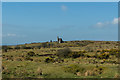
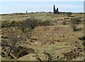
"2 Bronze Age round cairns both with evidence of early excavation and stone robbing. " - Pastscape.
You may be viewing yesterday's version of this page. To see the most up to date information please register for a free account.
")
Do not use the above information on other web sites or publications without permission of the contributor.
Nearby Images from Geograph Britain and Ireland:
©2019(licence)
©2015(licence)
©2021(licence)
©2010(licence)
©2021(licence)
The above images may not be of the site on this page, they are loaded from Geograph.
Please Submit an Image of this site or go out and take one for us!
Click here to see more info for this site
Nearby sites
Key: Red: member's photo, Blue: 3rd party photo, Yellow: other image, Green: no photo - please go there and take one, Grey: site destroyed
Download sites to:
KML (Google Earth)
GPX (GPS waypoints)
CSV (Garmin/Navman)
CSV (Excel)
To unlock full downloads you need to sign up as a Contributory Member. Otherwise downloads are limited to 50 sites.
Turn off the page maps and other distractions
Nearby sites listing. In the following links * = Image available
204m S 189° Trewalla Farm Settlement* Ancient Village or Settlement (SX25117106)
230m S 178° Minions Bronze Age round cairn. Cairn (SX25157103)
247m SSE 157° Minions Kerbed Cairn Cairn (SX25247103)
565m E 79° The Hurlers Pipers* Standing Stones (SX25717135)
566m SSE 157° Minions Cairns Cairn (SX25357073)
634m NNW 332° Craddock Moor circle* Stone Circle (SX24877183)
651m ESE 103° Minions Platform Round Barrow* Cairn (SX25787109)
662m E 82° The Hurlers (S)* Stone Circle (SX25817133)
680m ENE 77° The Hurlers (C)* Stone Circle (SX25827139)
692m ENE 76° The Hurlers* Stone Circle (SX25837140)
697m ENE 75° The Hurlers causeway* Ancient Trackway (SX25837142)
712m NNW 348° Craddock Moor platform cairn* Cairn (SX25027196)
714m ENE 73° The Hurlers (N)* Stone Circle (SX25847145)
790m ENE 63° The Hurlers North* Stone Circle (SX25877159)
809m SSE 149° The Long Stone (Minions)* Standing Stone (Menhir) (SX25547055)
815m W 280° Craddock Moor Cairn Cemetery* Barrow Cemetery (SX2435071429)
859m NE 43° The Hurlers Avenue* Multiple Stone Rows / Avenue (SX2576371864)
869m E 97° Minions Mound* Round Barrow(s) (SX26017112)
949m W 264° Tregarrick Tor hillfort* Hillfort (SX242712)
1.0km W 262° Tregarrick Tor cairn* Chambered Cairn (SX24157115)
1.1km NE 51° Rillaton Barrow* Round Barrow(s) (SX26027191)
1.1km NNW 336° Craddock Moor Stone Setting* Standing Stones (SX24747227)
1.1km NE 49° Rillaton N Cairn* Cairn (SX26007195)
1.1km NW 315° Craddock Moor embanked avenue* Misc. Earthwork (SX24377208)
1.2km ENE 57° Minions Settlement* Ancient Village or Settlement (SX262719)
View more nearby sites and additional images


 We would like to know more about this location. Please feel free to add a brief description and any relevant information in your own language.
 Wir möchten mehr über diese Stätte erfahren. Bitte zögern Sie nicht, eine kurze Beschreibung und relevante Informationen in Deutsch hinzuzufügen.
 Nous aimerions en savoir encore un peu sur les lieux. S'il vous plaît n'hesitez pas à ajouter une courte description et tous les renseignements pertinents dans votre propre langue.
 Quisieramos informarnos un poco más de las lugares. No dude en añadir una breve descripción y otros datos relevantes en su propio idioma.