


<< Our Photo Pages >> Withey Brook - Cairn in England in Cornwall
Submitted by markj99 on Sunday, 06 December 2020 Page Views: 614
Neolithic and Bronze AgeSite Name: Withey BrookCountry: England County: Cornwall Type: Cairn
Nearest Town: Callington Nearest Village: Sharptor
Map Ref: SX2482273656
Latitude: 50.536377N Longitude: 4.473374W
Condition:
| 5 | Perfect |
| 4 | Almost Perfect |
| 3 | Reasonable but with some damage |
| 2 | Ruined but still recognisable as an ancient site |
| 1 | Pretty much destroyed, possibly visible as crop marks |
| 0 | No data. |
| -1 | Completely destroyed |
| 5 | Superb |
| 4 | Good |
| 3 | Ordinary |
| 2 | Not Good |
| 1 | Awful |
| 0 | No data. |
| 5 | Can be driven to, probably with disabled access |
| 4 | Short walk on a footpath |
| 3 | Requiring a bit more of a walk |
| 2 | A long walk |
| 1 | In the middle of nowhere, a nightmare to find |
| 0 | No data. |
| 5 | co-ordinates taken by GPS or official recorded co-ordinates |
| 4 | co-ordinates scaled from a detailed map |
| 3 | co-ordinates scaled from a bad map |
| 2 | co-ordinates of the nearest village |
| 1 | co-ordinates of the nearest town |
| 0 | no data |
Internal Links:
External Links:
I have visited· I would like to visit
markj99 visited on 9th Apr 2018 - their rating: Cond: 2 Amb: 4 Access: 4 Withey Brook Cairn is easily found by following the directions in the webpage. It is one of many features on Langstane Downs created by ancient people including hut circles, settlements and field systems.
")
Withey Brook Round Cairn lies on the slopes of Withey Brook Valley on the edge of Langstone Downs. It is located in a Bronze age field system incorporating a hut circle settlement.
Withey Brook Cairn is a round cairn, 40 feet in diameter by 5 feet high, covered in grass with large exposed stones on the surface. The cairn is largely undisturbed except for a hollow 5 feet across by 1.5 feet deep on the summit of the cairn.
Historic England 1010308 notes its unusual setting on a lower slope however it is situated on a crest top in an occupied Bronze Age area denoting its context in the ancient environment.
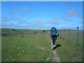
Directions: From the E edge of Minions turn into the Car Park then sharp R into a narrow country lane. Follow this for 1.33 miles until you reach the dead end L turn for Sharptor. The lane leads through Sharptor where the public road ends after 0.5 miles. There is room to park at SX 2579 7304 between Sharptor and Wardbrook Farm. Follow the dismantled railway track past Wardbrook Farm for 0.75 miles. Withey Brook Cairn lies within 50 yards on the L of the track, an obvious prominence in the landscape.
You may be viewing yesterday's version of this page. To see the most up to date information please register for a free account.
")
")
Do not use the above information on other web sites or publications without permission of the contributor.
Nearby Images from Geograph Britain and Ireland:
©2006(licence)
©2008(licence)
©2008(licence)
©2008(licence)
©2012(licence)
The above images may not be of the site on this page, they are loaded from Geograph.
Please Submit an Image of this site or go out and take one for us!
Click here to see more info for this site
Nearby sites
Key: Red: member's photo, Blue: 3rd party photo, Yellow: other image, Green: no photo - please go there and take one, Grey: site destroyed
Download sites to:
KML (Google Earth)
GPX (GPS waypoints)
CSV (Garmin/Navman)
CSV (Excel)
To unlock full downloads you need to sign up as a Contributory Member. Otherwise downloads are limited to 50 sites.
Turn off the page maps and other distractions
Nearby sites listing. In the following links * = Image available
479m E 83° Langstone Downs row Stone Row / Alignment (SX253737)
677m E 84° Langstone downs Cairns* Cairn (SX255737)
734m W 279° Siblyback Menhir* Standing Stone (Menhir) (SX241738)
813m NE 36° Bearah Tramway Cairn* Cairn (SX25327430)
864m NE 40° Bearah Tramway Cist* Cist (SX254743)
871m SW 228° Craddock Moor Prehistoric Settlement* Ancient Village or Settlement (SX24157310)
1.2km NE 42° Linkinhorne Reave Misc. Earthwork (SX2564274508)
1.2km N 11° High Rock propped stone* Natural Stone / Erratic / Other Natural Feature (SX2509074809)
1.2km NNE 16° Kilmar Tor* Rock Outcrop (SX252748)
1.3km NNE 16° Kilmar Tor propped stone* Natural Stone / Erratic / Other Natural Feature (SX2521374856)
1.4km N 10° Kilmar Tor North Propped Stone* Natural Stone / Erratic / Other Natural Feature (SX2510874982)
1.4km NNW 345° Trewortha Kerb cairn and cist* Chambered Cairn (SX24527499)
1.4km S 181° Craddock Moor Stone Setting* Standing Stones (SX24747227)
1.4km SW 216° Craddock Moor Hut Circle* Ancient Village or Settlement (SX23937253)
1.5km SE 139° Stowe's Pound* Ancient Village or Settlement (SX25787247)
1.6km SE 141° The Cheesewring* Natural Stone / Erratic / Other Natural Feature (SX25787239)
1.6km SSW 206° Craddock Moor stone row* Stone Row / Alignment (SX2407972244)
1.6km SSW 194° Craddock Moor embanked avenue* Misc. Earthwork (SX24377208)
1.6km N 11° Pyramid Stone (Kilmar Tor)* Natural Stone / Erratic / Other Natural Feature (SX25187526)
1.6km ENE 63° Bearah Common Long Cairn* Chambered Cairn (SX26327435)
1.7km S 171° Craddock Moor platform cairn* Cairn (SX25027196)
1.8km NNE 20° Twelve Men's Moor Cairns Barrow Cemetery (SX255753)
1.8km N 354° Trewortha Cairns* Cairn (SX24697543)
1.8km S 177° Craddock Moor circle* Stone Circle (SX24877183)
1.9km N 7° Twelve men's moor cairn and cist* Cist (SX25117551)
View more nearby sites and additional images


 We would like to know more about this location. Please feel free to add a brief description and any relevant information in your own language.
 Wir möchten mehr über diese Stätte erfahren. Bitte zögern Sie nicht, eine kurze Beschreibung und relevante Informationen in Deutsch hinzuzufügen.
 Nous aimerions en savoir encore un peu sur les lieux. S'il vous plaît n'hesitez pas à ajouter une courte description et tous les renseignements pertinents dans votre propre langue.
 Quisieramos informarnos un poco más de las lugares. No dude en añadir una breve descripción y otros datos relevantes en su propio idioma.