

<< Our Photo Pages >> Marhamchurch Medieval cross - Ancient Cross in England in Cornwall
Submitted by dooclay on Friday, 10 February 2023 Page Views: 407
Medieval (High and Late)Site Name: Marhamchurch Medieval crossCountry: England
NOTE: This site is 2.3 km away from the location you searched for.
County: Cornwall Type: Ancient Cross
Nearest Town: Bude Nearest Village: Marhamchurch
Map Ref: SS22300369
Latitude: 50.805444N Longitude: 4.523361W
Condition:
| 5 | Perfect |
| 4 | Almost Perfect |
| 3 | Reasonable but with some damage |
| 2 | Ruined but still recognisable as an ancient site |
| 1 | Pretty much destroyed, possibly visible as crop marks |
| 0 | No data. |
| -1 | Completely destroyed |
| 5 | Superb |
| 4 | Good |
| 3 | Ordinary |
| 2 | Not Good |
| 1 | Awful |
| 0 | No data. |
| 5 | Can be driven to, probably with disabled access |
| 4 | Short walk on a footpath |
| 3 | Requiring a bit more of a walk |
| 2 | A long walk |
| 1 | In the middle of nowhere, a nightmare to find |
| 0 | No data. |
| 5 | co-ordinates taken by GPS or official recorded co-ordinates |
| 4 | co-ordinates scaled from a detailed map |
| 3 | co-ordinates scaled from a bad map |
| 2 | co-ordinates of the nearest village |
| 1 | co-ordinates of the nearest town |
| 0 | no data |
Internal Links:
External Links:
")
From the Cornwall HER:
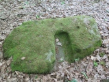
A small latin cross of granite is clamped to a blind arch on the interior north-west wall of Marhamchurch parish church. The monument has a tapered shaft with stunted horizontal limbs and displays an incised latin cross on its face. The reverse face cannot be seen. Langdon in 1992 records that it may have been found in the churchyard and that it could be an early gravestone. The cross measures 0.46m in height, width 0.2m, thickness 0.075m (b1).
You may be viewing yesterday's version of this page. To see the most up to date information please register for a free account.
Do not use the above information on other web sites or publications without permission of the contributor.
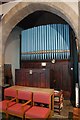
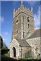
Nearby Images from Geograph Britain and Ireland:
©2017(licence)
©2012(licence)
©2012(licence)
©2012(licence)
©2009(licence)
The above images may not be of the site on this page, they are loaded from Geograph.
Please Submit an Image of this site or go out and take one for us!
Click here to see more info for this site
Nearby sites
Key: Red: member's photo, Blue: 3rd party photo, Yellow: other image, Green: no photo - please go there and take one, Grey: site destroyed
Download sites to:
KML (Google Earth)
GPX (GPS waypoints)
CSV (Garmin/Navman)
CSV (Excel)
To unlock full downloads you need to sign up as a Contributory Member. Otherwise downloads are limited to 50 sites.
Turn off the page maps and other distractions
Nearby sites listing. In the following links * = Image available
1.4km WSW 248° Whalesborough Barrows* Round Barrow(s) (SS21020323)
1.4km NW 315° Neet Valley stone, Bude Standing Stone (Menhir) (SS21320474)
2.4km W 273° Higher Longbeak Barrow* Round Barrow(s) (SS19950389)
2.5km WSW 257° Widemouth Bay tumulus* Round Barrow(s) (SS19870323)
2.9km NE 44° St Swithin's Well (Launcells)* Holy Well or Sacred Spring (SS244057)
3.4km N 6° Stamford Hill settlement* Ancient Village or Settlement (SS22750705)
3.5km NW 318° Compass Point Barrow* Round Barrow(s) (SS20040635)
4.0km N 357° Earthquake Cist* Cist (SS22250773)
4.1km SSW 209° St Neot's Well (Poundstock)* Holy Well or Sacred Spring (SS2018800184)
4.8km NNW 334° Northcott Mouth Tumuli* Barrow Cemetery (SS203081)
4.9km SE 142° Hilton Wood Castle* Hillfort (SX25229969)
5.1km SE 140° Froxton Wood Castle Hillfort (SX2543099705)
6.2km S 173° Ashbury hillfort* Hillfort (SX228975)
6.5km SE 140° St Anne's Well (Whitstone)* Holy Well or Sacred Spring (SX263985)
8.1km SSW 201° St James's Well (Jacobstow)* Holy Well or Sacred Spring (SX19149619)
9.0km SE 143° Kiddy Barrow* Barrow Cemetery (SX27499637)
9.1km SE 146° Wilsworthy Cross Barrows* Barrow Cemetery (SX2716496017)
9.4km SE 135° Mount Pleasant Barrows* Barrow Cemetery (SX28769679)
9.7km SSW 205° Wainhouse Corner Barrows* Round Barrow(s) (SX17889510)
9.9km NNE 24° Taylors Cross Tumuli* Round Barrow(s) (SS2669012535)
9.9km SW 226° St Genny's Well* Holy Well or Sacred Spring (SX149971)
10.2km SSE 150° Chelsfield Barrows* Barrow Cemetery (SX27049467)
10.2km ESE 108° Affaland Moor Bowl Barrow* Round Barrow(s) (SS3196200184)
10.5km ENE 67° Ugworthy Beacon Barrows* Round Barrow(s) (SS3217607440)
10.6km SSW 203° Small Hill Tumuli* Barrow Cemetery (SX17769408)
View more nearby sites and additional images


 We would like to know more about this location. Please feel free to add a brief description and any relevant information in your own language.
 Wir möchten mehr über diese Stätte erfahren. Bitte zögern Sie nicht, eine kurze Beschreibung und relevante Informationen in Deutsch hinzuzufügen.
 Nous aimerions en savoir encore un peu sur les lieux. S'il vous plaît n'hesitez pas à ajouter une courte description et tous les renseignements pertinents dans votre propre langue.
 Quisieramos informarnos un poco más de las lugares. No dude en añadir una breve descripción y otros datos relevantes en su propio idioma.