


<< Our Photo Pages >> Trewortha Cairns - Cairn in England in Cornwall
Submitted by dooclay on Sunday, 23 October 2022 Page Views: 341
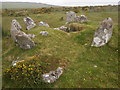
Neolithic and Bronze AgeSite Name: Trewortha CairnsCountry: England
NOTE: This site is 0.4 km away from the location you searched for.
County: Cornwall Type: Cairn
Nearest Town: Launceston Nearest Village: North Hill
Map Ref: SX24697543
Latitude: 50.552276N Longitude: 4.47607W
Condition:
| 5 | Perfect |
| 4 | Almost Perfect |
| 3 | Reasonable but with some damage |
| 2 | Ruined but still recognisable as an ancient site |
| 1 | Pretty much destroyed, possibly visible as crop marks |
| 0 | No data. |
| -1 | Completely destroyed |
| 5 | Superb |
| 4 | Good |
| 3 | Ordinary |
| 2 | Not Good |
| 1 | Awful |
| 0 | No data. |
| 5 | Can be driven to, probably with disabled access |
| 4 | Short walk on a footpath |
| 3 | Requiring a bit more of a walk |
| 2 | A long walk |
| 1 | In the middle of nowhere, a nightmare to find |
| 0 | No data. |
| 5 | co-ordinates taken by GPS or official recorded co-ordinates |
| 4 | co-ordinates scaled from a detailed map |
| 3 | co-ordinates scaled from a bad map |
| 2 | co-ordinates of the nearest village |
| 1 | co-ordinates of the nearest town |
| 0 | no data |
Internal Links:
External Links:
I have visited· I would like to visit
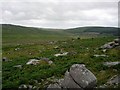
markj99 visited on 8th Jun 2023 - their rating: Cond: 2 Amb: 4 Access: 3 I have spent more time than I care to recall wandering Twelve Men's Moor searching for cairns. It is a particularly frustrating experience rewarded by the discovery of an occasional cist and cairn.
")
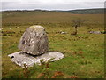
A group of Cairns, some of which may be clearance Cairns
SX 2479/7548 HER 1013.01
SX 2487/7546 HER 1013.02
SX 2471/7545 HER 1013.03
SX 2470/7544 HER 1013.04
SX 2471/7544 HER 1013.05
SX 2471/7546 HER 1013.06
SX 2473/7545 HER 1013.08
SX 2474/7545 HER 1013.09
SX 2477/7547 HER 1013.10
SX 2469/7543 HER 1013.11
You may be viewing yesterday's version of this page. To see the most up to date information please register for a free account.
")
")
")
Do not use the above information on other web sites or publications without permission of the contributor.
Nearby Images from Geograph Britain and Ireland:
©2006(licence)
©2015(licence)
©2021(licence)
©2015(licence)
©2015(licence)
The above images may not be of the site on this page, they are loaded from Geograph.
Please Submit an Image of this site or go out and take one for us!
Click here to see more info for this site
Nearby sites
Key: Red: member's photo, Blue: 3rd party photo, Yellow: other image, Green: no photo - please go there and take one, Grey: site destroyed
Download sites to:
KML (Google Earth)
GPX (GPS waypoints)
CSV (Garmin/Navman)
CSV (Excel)
To unlock full downloads you need to sign up as a Contributory Member. Otherwise downloads are limited to 50 sites.
Turn off the page maps and other distractions
Nearby sites listing. In the following links * = Image available
353m ENE 59° Twelve men's moor bronze age settlement* Ancient Village or Settlement (SX250756)
426m ENE 77° Twelve men's moor cairn and cist* Cist (SX25117551)
471m SSW 199° Trewortha Kerb cairn and cist* Chambered Cairn (SX24527499)
517m ESE 107° Pyramid Stone (Kilmar Tor)* Natural Stone / Erratic / Other Natural Feature (SX25187526)
612m SE 135° Kilmar Tor North Propped Stone* Natural Stone / Erratic / Other Natural Feature (SX2510874982)
685m WNW 289° King Arthur's Bed* Natural Stone / Erratic / Other Natural Feature (SX24057568)
738m SE 145° High Rock propped stone* Natural Stone / Erratic / Other Natural Feature (SX2509074809)
775m SE 136° Kilmar Tor propped stone* Natural Stone / Erratic / Other Natural Feature (SX2521374856)
809m SE 139° Kilmar Tor* Rock Outcrop (SX252748)
818m E 97° Twelve Men's Moor Cairns Barrow Cemetery (SX255753)
1.1km NE 34° Hawk's Tor (South)* Stone Row / Alignment (SX2532476301)
1.3km SSE 149° Bearah Tramway Cairn* Cairn (SX25327430)
1.3km SE 132° Linkinhorne Reave Misc. Earthwork (SX2564274508)
1.3km SE 146° Bearah Tramway Cist* Cist (SX254743)
1.7km SSW 198° Siblyback Menhir* Standing Stone (Menhir) (SX241738)
1.8km S 174° Withey Brook* Cairn (SX2482273656)
1.8km NNE 33° Allabury Hillfort (SX257769)
1.8km SSE 159° Langstone Downs row Stone Row / Alignment (SX253737)
1.9km SSE 153° Langstone downs Cairns* Cairn (SX255737)
2.0km ESE 122° Bearah Common Long Cairn* Chambered Cairn (SX26327435)
2.1km N 360° Bowda Stone Circle* Stone Circle (SX24757757)
2.4km S 191° Craddock Moor Prehistoric Settlement* Ancient Village or Settlement (SX24157310)
2.4km NW 324° Redmoor Marsh* Misc. Earthwork (SX23327742)
2.4km WNW 301° Colquite Menhir* Standing Stone (Menhir) (SX22657675)
2.4km N 350° The Ridge Cairn* Cairn (SX24337785)
View more nearby sites and additional images


 We would like to know more about this location. Please feel free to add a brief description and any relevant information in your own language.
 Wir möchten mehr über diese Stätte erfahren. Bitte zögern Sie nicht, eine kurze Beschreibung und relevante Informationen in Deutsch hinzuzufügen.
 Nous aimerions en savoir encore un peu sur les lieux. S'il vous plaît n'hesitez pas à ajouter une courte description et tous les renseignements pertinents dans votre propre langue.
 Quisieramos informarnos un poco más de las lugares. No dude en añadir una breve descripción y otros datos relevantes en su propio idioma.