


<< Our Photo Pages >> Shanter Knowe - Artificial Mound in Scotland in South Ayrshire
Submitted by durhamnature on Wednesday, 31 October 2012 Page Views: 3271
Multi-periodSite Name: Shanter KnoweCountry: Scotland
NOTE: This site is 5.0 km away from the location you searched for.
County: South Ayrshire Type: Artificial Mound
Map Ref: NS21890738
Latitude: 55.328126N Longitude: 4.809155W
Condition:
| 5 | Perfect |
| 4 | Almost Perfect |
| 3 | Reasonable but with some damage |
| 2 | Ruined but still recognisable as an ancient site |
| 1 | Pretty much destroyed, possibly visible as crop marks |
| 0 | No data. |
| -1 | Completely destroyed |
| 5 | Superb |
| 4 | Good |
| 3 | Ordinary |
| 2 | Not Good |
| 1 | Awful |
| 0 | No data. |
| 5 | Can be driven to, probably with disabled access |
| 4 | Short walk on a footpath |
| 3 | Requiring a bit more of a walk |
| 2 | A long walk |
| 1 | In the middle of nowhere, a nightmare to find |
| 0 | No data. |
| 5 | co-ordinates taken by GPS or official recorded co-ordinates |
| 4 | co-ordinates scaled from a detailed map |
| 3 | co-ordinates scaled from a bad map |
| 2 | co-ordinates of the nearest village |
| 1 | co-ordinates of the nearest town |
| 0 | no data |
Be the first person to rate this site - see the 'Contribute!' box in the right hand menu.
Internal Links:
External Links:
")
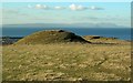
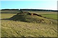
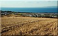
Shanter Knowe is a grass-covered mound of unknown origin, possibly a motte, placed on sloping ground, its height varying from 4 to 6m. Its flat top is 9m by 8m in diameter and the base is roughly 25m in diameter. There is no evidence of its ever having been enclosed by a ditch.
It was excavated in 1894 by the Marquis of Ailsa. Dark, loamy soil was found about 1.80m down below sand and pebbles, and it was only at this depth that relics were found. These were animal bones, teeth, a flint scraper, flint cores and flakes (in NMAS), a bronze pin, a lead whorl, part of an iron chain, some wheel-turned, partly glazed pottery and shells.
The RCAHMS consider that the finds doubtless represent an earlier occupation of the site. After the excavation, the soil was replaced and the mound restored to its former state.
More information can be found on Canmore ID 40852, which says this is probably a motte of medieval date.
You may be viewing yesterday's version of this page. To see the most up to date information please register for a free account.
")
")
Do not use the above information on other web sites or publications without permission of the contributor.
Nearby Images from Geograph Britain and Ireland:
©2010(licence)
©2010(licence)
©2010(licence)
©2010(licence)
©2010(licence)
The above images may not be of the site on this page, they are loaded from Geograph.
Please Submit an Image of this site or go out and take one for us!
Click here to see more info for this site
Nearby sites
Key: Red: member's photo, Blue: 3rd party photo, Yellow: other image, Green: no photo - please go there and take one, Grey: site destroyed
Download sites to:
KML (Google Earth)
GPX (GPS waypoints)
CSV (Garmin/Navman)
CSV (Excel)
To unlock full downloads you need to sign up as a Contributory Member. Otherwise downloads are limited to 50 sites.
Turn off the page maps and other distractions
Nearby sites listing. In the following links * = Image available
1.2km WNW 285° Bains Hill* Standing Stone (Menhir) (NS20750773)
5.1km SE 127° East Threave* Cairn (NS25870411)
5.4km NE 43° Balchriston* Stone Fort or Dun (NS2572911176)
7.1km SE 135° Cairn Hill (Dalquharran)* Cairn (NS26690219)
7.3km NE 50° Howmoor* Stone Fort or Dun (NS2770711809)
7.6km ESE 118° Captain's Bridge (Drummochreen) W* Hillfort (NS28510356)
7.7km ESE 118° Captain's Bridge (Drummochreen) SE* Stone Fort or Dun (NS28530351)
7.9km E 88° Kildoon Hillfort* Hillfort (NS29860738)
9.3km SSE 152° Maxwelstone Camp* Hillfort (NX25959895)
9.6km ENE 69° Lyonston Stone* Standing Stone (Menhir) (NS30991039)
14.1km ESE 117° Knockinculloch* Ancient Village or Settlement (NS34200050)
14.3km S 185° Dinvin Earthworks* Misc. Earthwork (NX2002993173)
14.6km NE 49° Wallace's Stone (Blairstone Mains)* Early Christian Sculptured Stone (NS3321416579)
15.3km NE 40° Stonefield Park, Ayr* Standing Stone (Menhir) (NS32271869)
16.3km ENE 63° Barbieston Farm cist* Cist (NS36751417)
17.6km SE 135° Bencallen Hill* Chambered Cairn (NX33779440)
19.5km S 178° Glake Stone* Standing Stone (Menhir) (NX21678790)
20.7km ESE 115° Cairnwhapple Stone* Natural Stone / Erratic / Other Natural Feature (NX40399796)
21.6km NE 34° Bruce's Well (Prestwick)* Holy Well or Sacred Spring (NS3467624801)
22.8km NW 304° Kildonan (Arran)* Standing Stone (Menhir) (NS0337220870)
22.9km NW 312° Largybeg Point* Stone Circle (NS0536323338)
23.1km NW 309° Dippen (Arran)* Chambered Cairn (NS044226)
23.3km SSE 167° Balmalloch Chambered Cairn* Chambered Cairn (NX2638784532)
23.4km SSE 166° Balmalloch Cairnfield* Barrow Cemetery (NX26488439)
24.4km SE 144° Cairnfore* Cairn (NX35548707)
View more nearby sites and additional images


 We would like to know more about this location. Please feel free to add a brief description and any relevant information in your own language.
 Wir möchten mehr über diese Stätte erfahren. Bitte zögern Sie nicht, eine kurze Beschreibung und relevante Informationen in Deutsch hinzuzufügen.
 Nous aimerions en savoir encore un peu sur les lieux. S'il vous plaît n'hesitez pas à ajouter une courte description et tous les renseignements pertinents dans votre propre langue.
 Quisieramos informarnos un poco más de las lugares. No dude en añadir una breve descripción y otros datos relevantes en su propio idioma.