


<< Our Photo Pages >> Pentre Galar - Cairn in Wales in Pembrokeshire
Submitted by vicky on Sunday, 29 September 2002 Page Views: 5339
Neolithic and Bronze AgeSite Name: Pentre GalarCountry: Wales
NOTE: This site is 0.5 km away from the location you searched for.
County: Pembrokeshire Type: Cairn
Nearest Town: Newport Nearest Village: Pentre Galar
Map Ref: SN172307 Landranger Map Number: 145
Latitude: 51.944684N Longitude: 4.661044W
Condition:
| 5 | Perfect |
| 4 | Almost Perfect |
| 3 | Reasonable but with some damage |
| 2 | Ruined but still recognisable as an ancient site |
| 1 | Pretty much destroyed, possibly visible as crop marks |
| 0 | No data. |
| -1 | Completely destroyed |
| 5 | Superb |
| 4 | Good |
| 3 | Ordinary |
| 2 | Not Good |
| 1 | Awful |
| 0 | No data. |
| 5 | Can be driven to, probably with disabled access |
| 4 | Short walk on a footpath |
| 3 | Requiring a bit more of a walk |
| 2 | A long walk |
| 1 | In the middle of nowhere, a nightmare to find |
| 0 | No data. |
| 5 | co-ordinates taken by GPS or official recorded co-ordinates |
| 4 | co-ordinates scaled from a detailed map |
| 3 | co-ordinates scaled from a bad map |
| 2 | co-ordinates of the nearest village |
| 1 | co-ordinates of the nearest town |
| 0 | no data |
Internal Links:
External Links:
")
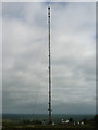
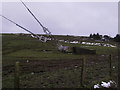
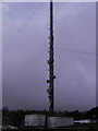
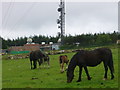
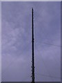
A cairn once stood under what is now the foundations for a TV mast, a prominent landmark for miles around. According to records the cairn had been destroyed to build the nearby road long before the mast was erected.
The cairn possibly had a cist within it in which an axe hammer was found in 1927.
References
N.P.Figgis "Prehistoric Preseli" (2001)
You may be viewing yesterday's version of this page. To see the most up to date information please register for a free account.
Do not use the above information on other web sites or publications without permission of the contributor.
Nearby Images from Geograph Britain and Ireland:
©2007(licence)
©2012(licence)
©2012(licence)
©2007(licence)
©2012(licence)
The above images may not be of the site on this page, they are loaded from Geograph.
Please Submit an Image of this site or go out and take one for us!
Click here to see more info for this site
Nearby sites
Key: Red: member's photo, Blue: 3rd party photo, Yellow: other image, Green: no photo - please go there and take one, Grey: site destroyed
Download sites to:
KML (Google Earth)
GPX (GPS waypoints)
CSV (Garmin/Navman)
CSV (Excel)
To unlock full downloads you need to sign up as a Contributory Member. Otherwise downloads are limited to 50 sites.
Turn off the page maps and other distractions
Nearby sites listing. In the following links * = Image available
719m ESE 122° Ffynon Delyn Henge (SN178303)
979m W 264° Dolaumaen Standing Stone* Standing Stone (Menhir) (SN1622030632)
1.5km WSW 240° Foel Dyrch, Pentre Galar Cairn (SN159300)
1.5km WNW 290° Waun Llwyd.* Standing Stones (SN1578131265)
1.8km N 1° Crug yr Hwch Round Cairn (SN173325)
2.2km NNW 342° Mountain Burial Chamber* Burial Chamber or Dolmen (SN16573285)
2.6km NNW 342° Croesmihangel Barrow* Round Barrow(s) (SN165332)
2.6km N 349° Croesmihangel Ancient Village or Settlement (SN168333)
2.6km NNW 328° Carn Gaseg Ring Cairn (SN159330)
2.8km NW 320° Carn Ferched Standing Stones* Standing Stones (SN155329)
2.8km SE 136° Efessangus stone* Early Christian Sculptured Stone (SN191286)
2.9km WNW 285° Carn Menyn (Gate Post?)* Standing Stone (Menhir) (SN1438131557)
3.0km NW 318° Carn Ferched Cairn* Round Cairn (SN153330)
3.2km NNE 16° Crymych Wayside Barrow* Round Barrow(s) (SN18203375)
3.2km NNW 332° Foel Drygarn Fort* Hillfort (SN158336)
3.2km NNW 332° Foel Drygarn Track Ancient Trackway (SN158336)
3.2km NNW 332° Foel Drygarn Cairns* Cairn (SN15773359)
3.3km WNW 303° Carngyfrwy Round Barrow(s) (SN145326)
3.3km WNW 301° Carn Meini* Ancient Mine, Quarry or other Industry (SN1441432482)
3.4km SSW 205° Carn Besi* Chambered Tomb (SN15632768)
3.4km WNW 298° Carn Menyn - Worked Stone* Ancient Mine, Quarry or other Industry (SN1423132432)
3.5km WNW 300° Carn Menyn Marker* Standing Stone (Menhir) (SN1424132570)
3.6km ENE 77° Llanfyrnach A* Standing Stone (Menhir) (SN20753141)
3.6km E 80° Llanfyrnach B* Standing Stone (Menhir) (SN20793121)
3.7km W 263° Bluestones Monument* Modern Stone Circle etc (SN13533038)
View more nearby sites and additional images


 We would like to know more about this location. Please feel free to add a brief description and any relevant information in your own language.
 Wir möchten mehr über diese Stätte erfahren. Bitte zögern Sie nicht, eine kurze Beschreibung und relevante Informationen in Deutsch hinzuzufügen.
 Nous aimerions en savoir encore un peu sur les lieux. S'il vous plaît n'hesitez pas à ajouter une courte description et tous les renseignements pertinents dans votre propre langue.
 Quisieramos informarnos un poco más de las lugares. No dude en añadir una breve descripción y otros datos relevantes en su propio idioma.