


<< Our Photo Pages >> Newhouse Barrows - Barrow Cemetery in Wales in Pembrokeshire
Submitted by PJK7009 on Monday, 07 December 2015 Page Views: 1353
Neolithic and Bronze AgeSite Name: Newhouse BarrowsCountry: Wales
NOTE: This site is 0.3 km away from the location you searched for.
County: Pembrokeshire Type: Barrow Cemetery
Nearest Town: Narberth Nearest Village: Ludchurch
Map Ref: SN15711141
Latitude: 51.770947N Longitude: 4.672405W
Condition:
| 5 | Perfect |
| 4 | Almost Perfect |
| 3 | Reasonable but with some damage |
| 2 | Ruined but still recognisable as an ancient site |
| 1 | Pretty much destroyed, possibly visible as crop marks |
| 0 | No data. |
| -1 | Completely destroyed |
| 5 | Superb |
| 4 | Good |
| 3 | Ordinary |
| 2 | Not Good |
| 1 | Awful |
| 0 | No data. |
| 5 | Can be driven to, probably with disabled access |
| 4 | Short walk on a footpath |
| 3 | Requiring a bit more of a walk |
| 2 | A long walk |
| 1 | In the middle of nowhere, a nightmare to find |
| 0 | No data. |
| 5 | co-ordinates taken by GPS or official recorded co-ordinates |
| 4 | co-ordinates scaled from a detailed map |
| 3 | co-ordinates scaled from a bad map |
| 2 | co-ordinates of the nearest village |
| 1 | co-ordinates of the nearest town |
| 0 | no data |
Internal Links:
External Links:
")
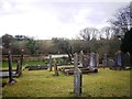
Barrow 1 at SN15711141 is a pointed topped barrow in the corner of a field that can be seen from the road.
Coflein; One of three barrows (see Nprn304251), 24m in diameter and 1.2m high.
(source Os495card; SN11SE7)
RCAHMWE AP945037/58
J.Wiles 27.04.04
Barrow 2 at SN15991145 is the larger of the three mounds and has a flat summit. It can be seen from the road.
Coflein; One of three barrows (see Nprn304251), 30m in diameter and 1.4m high.
(source Os495card; SN11SE7)
RCAHMW AP945037/58
J.Wiles 27.04.04
Barrow 3 at SN15861146 is easy to miss and sits between the two larger mounds.
Coflein; One of three barrows, 24m in diameter & 0.6m high.
Associated with: Barrow I (Nprn400215), c.140m to the WSW; Barrow III (Nprn400216), c.100m to the E. A recumbent monolith (Nprn304250) lies c.65m to the S.
You may be viewing yesterday's version of this page. To see the most up to date information please register for a free account.
")
Do not use the above information on other web sites or publications without permission of the contributor.
Nearby Images from Geograph Britain and Ireland:
©2007(licence)
©2007(licence)
©2016(licence)
©2013(licence)
©2014(licence)
The above images may not be of the site on this page, they are loaded from Geograph.
Please Submit an Image of this site or go out and take one for us!
Click here to see more info for this site
Nearby sites
Key: Red: member's photo, Blue: 3rd party photo, Yellow: other image, Green: no photo - please go there and take one, Grey: site destroyed
Download sites to:
KML (Google Earth)
GPX (GPS waypoints)
CSV (Garmin/Navman)
CSV (Excel)
To unlock full downloads you need to sign up as a Contributory Member. Otherwise downloads are limited to 50 sites.
Turn off the page maps and other distractions
Nearby sites listing. In the following links * = Image available
501m W 274° Belle Vue* Standing Stone (Menhir) (SN15211146)
1.6km SSW 204° Longstone Camp* Hillfort (SN14990996)
2.2km ENE 64° Crug Swllt* Round Barrow(s) (SN17711231)
2.3km SSW 207° The Longstone (Pembrokeshire)* Standing Stone (Menhir) (SN146094)
2.8km NNW 337° Llan Chambered Tomb* Chambered Tomb (SN147140)
3.7km ESE 102° Parc-y-Twmp* Round Barrow(s) (SN19341051)
4.4km W 269° Templeton Cross* Early Christian Sculptured Stone (SN1131011528)
4.6km W 273° St Margaret's Well (Pembrokeshire)* Holy Well or Sacred Spring (SN11101186)
4.6km S 173° Amroth Submerged Forest Not Known (by us) (SN16070678)
4.6km S 173° Amroth Submerged Forest Not Known (by us) (SN16070678)
4.8km NNW 342° Llanddewigaer* Hillfort (SN144160)
4.8km NNW 330° Ffynnon Dewi (Llanddewi Velfrey) Holy Well or Sacred Spring (SN13461565)
5.0km NNW 338° Caerau Gaer* Hillfort (SN14001609)
5.3km SE 133° Top Castle, Eglwyscummin* Hillfort (SN19460772)
5.9km ESE 111° Marros settlement* Ancient Village or Settlement (SN212091)
7.1km N 350° Triangle of stones near Llanddewi Velfrey* Modern Stone Circle etc (SN1477418468)
7.5km ESE 119° Morfa Bychan* Chambered Cairn (SN22130749)
7.6km NNE 13° St Canna's Stone (Llangan)* Natural Stone / Erratic / Other Natural Feature (SN17701874)
7.7km ESE 121° Forest Chamber* Burial Chamber or Dolmen (SN22180724)
8.0km ESE 116° Gilman Point fort* Promontory Fort / Cliff Castle (SN228076)
8.3km ESE 114° Pendine Bone Cave* Cave or Rock Shelter (SN23200782)
8.7km NNE 12° Henllan Amgoed Inscribed Stone* Standing Stone (Menhir) (SN1776719862)
8.9km E 79° Castell Pen-Y-Coed Hillfort (SN24531278)
9.1km WNW 284° Foel Eryr Hut Circle* Ancient Village or Settlement (SN069139)
9.4km ENE 71° Vaynor Farm Henge* Henge (SN24701417)
View more nearby sites and additional images


 We would like to know more about this location. Please feel free to add a brief description and any relevant information in your own language.
 Wir möchten mehr über diese Stätte erfahren. Bitte zögern Sie nicht, eine kurze Beschreibung und relevante Informationen in Deutsch hinzuzufügen.
 Nous aimerions en savoir encore un peu sur les lieux. S'il vous plaît n'hesitez pas à ajouter une courte description et tous les renseignements pertinents dans votre propre langue.
 Quisieramos informarnos un poco más de las lugares. No dude en añadir una breve descripción y otros datos relevantes en su propio idioma.