


<< Our Photo Pages >> Carn Ferched Standing Stones - Standing Stones in Wales in Pembrokeshire
Submitted by Hurricane_Luis on Saturday, 23 March 2013 Page Views: 3720
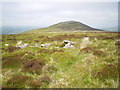
Neolithic and Bronze AgeSite Name: Carn Ferched Standing StonesCountry: Wales County: Pembrokeshire Type: Standing Stones
Nearest Town: Crymych Nearest Village: Mynachlog-ddu
Map Ref: SN155329
Latitude: 51.963881N Longitude: 4.68693W
Condition:
| 5 | Perfect |
| 4 | Almost Perfect |
| 3 | Reasonable but with some damage |
| 2 | Ruined but still recognisable as an ancient site |
| 1 | Pretty much destroyed, possibly visible as crop marks |
| 0 | No data. |
| -1 | Completely destroyed |
| 5 | Superb |
| 4 | Good |
| 3 | Ordinary |
| 2 | Not Good |
| 1 | Awful |
| 0 | No data. |
| 5 | Can be driven to, probably with disabled access |
| 4 | Short walk on a footpath |
| 3 | Requiring a bit more of a walk |
| 2 | A long walk |
| 1 | In the middle of nowhere, a nightmare to find |
| 0 | No data. |
| 5 | co-ordinates taken by GPS or official recorded co-ordinates |
| 4 | co-ordinates scaled from a detailed map |
| 3 | co-ordinates scaled from a bad map |
| 2 | co-ordinates of the nearest village |
| 1 | co-ordinates of the nearest town |
| 0 | no data |
Internal Links:
External Links:
I have visited· I would like to visit
Serenstar Horatio would like to visit
")
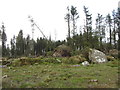
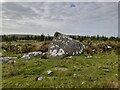
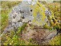
2 Standing Stones and a fallen one, The site is north of a conifer woodland.
You may be viewing yesterday's version of this page. To see the most up to date information please register for a free account.
")
")
Do not use the above information on other web sites or publications without permission of the contributor.
Nearby Images from Geograph Britain and Ireland:
©2016(licence)
©2022(licence)
©2022(licence)
©2022(licence)
©2011(licence)
The above images may not be of the site on this page, they are loaded from Geograph.
Please Submit an Image of this site or go out and take one for us!
Click here to see more info for this site
Nearby sites
Key: Red: member's photo, Blue: 3rd party photo, Yellow: other image, Green: no photo - please go there and take one, Grey: site destroyed
Download sites to:
KML (Google Earth)
GPX (GPS waypoints)
CSV (Garmin/Navman)
CSV (Excel)
To unlock full downloads you need to sign up as a Contributory Member. Otherwise downloads are limited to 50 sites.
Turn off the page maps and other distractions
Nearby sites listing. In the following links * = Image available
223m WNW 295° Carn Ferched Cairn* Round Cairn (SN153330)
411m ENE 74° Carn Gaseg Ring Cairn (SN159330)
740m NNE 19° Foel Drygarn Cairns* Cairn (SN15773359)
761m NNE 21° Foel Drygarn Fort* Hillfort (SN158336)
761m NNE 21° Foel Drygarn Track Ancient Trackway (SN158336)
1.0km WSW 251° Carngyfrwy Round Barrow(s) (SN145326)
1.0km ENE 71° Croesmihangel Barrow* Round Barrow(s) (SN165332)
1.1km E 91° Mountain Burial Chamber* Burial Chamber or Dolmen (SN16573285)
1.2km WSW 247° Carn Meini* Ancient Mine, Quarry or other Industry (SN1441432482)
1.3km WSW 253° Carn Menyn Marker* Standing Stone (Menhir) (SN1424132570)
1.3km WSW 248° Carn Menyn - Worked Stone* Ancient Mine, Quarry or other Industry (SN1423132432)
1.4km ENE 71° Croesmihangel Ancient Village or Settlement (SN168333)
1.4km W 266° Carn Gwr Sourthern Cairn Cairn (SN14113285)
1.4km W 268° Carn Gwr Cairn (SN14083290)
1.5km WSW 257° Carn Meini Tomb* Chambered Tomb (SN14033262)
1.5km NNW 328° Modern Stone Circle at Ty'r-bwlch* Modern Stone Circle etc (SN1474234210)
1.5km WSW 257° Carn Menyn* Round Cairn (SN140326)
1.6km WSW 255° Carn Breseb Pointer* Standing Stone (Menhir) (SN1392332532)
1.7km WSW 254° Stone River Stone* Standing Stone (Menhir) (SN1388832496)
1.7km SSE 168° Waun Llwyd.* Standing Stones (SN1578131265)
1.7km SW 218° Carn Menyn (Gate Post?)* Standing Stone (Menhir) (SN1438131557)
1.8km WNW 295° Carn Alw* Ancient Village or Settlement (SN139337)
1.8km E 100° Crug yr Hwch Round Cairn (SN173325)
2.2km NNW 345° Lach y Fleiddast Burial Chamber or Dolmen (SN1535)
2.2km WSW 250° Carn Arthur* Natural Stone / Erratic / Other Natural Feature (SN1337532232)
View more nearby sites and additional images


 We would like to know more about this location. Please feel free to add a brief description and any relevant information in your own language.
 Wir möchten mehr über diese Stätte erfahren. Bitte zögern Sie nicht, eine kurze Beschreibung und relevante Informationen in Deutsch hinzuzufügen.
 Nous aimerions en savoir encore un peu sur les lieux. S'il vous plaît n'hesitez pas à ajouter une courte description et tous les renseignements pertinents dans votre propre langue.
 Quisieramos informarnos un poco más de las lugares. No dude en añadir una breve descripción y otros datos relevantes en su propio idioma.