 with our Megalithic Portal iPhone app")


<< Our Photo Pages >> Mull of Galloway - Ancient Village or Settlement in Scotland in Dumfries and Galloway
Submitted by andyturner on Thursday, 03 June 2004 Page Views: 17644
Multi-periodSite Name: Mull of GallowayCountry: Scotland County: Dumfries and Galloway Type: Ancient Village or Settlement
Map Ref: NX1438130735 Landranger Map Number: 82
Latitude: 54.637488N Longitude: 4.877684W
Condition:
| 5 | Perfect |
| 4 | Almost Perfect |
| 3 | Reasonable but with some damage |
| 2 | Ruined but still recognisable as an ancient site |
| 1 | Pretty much destroyed, possibly visible as crop marks |
| 0 | No data. |
| -1 | Completely destroyed |
| 5 | Superb |
| 4 | Good |
| 3 | Ordinary |
| 2 | Not Good |
| 1 | Awful |
| 0 | No data. |
| 5 | Can be driven to, probably with disabled access |
| 4 | Short walk on a footpath |
| 3 | Requiring a bit more of a walk |
| 2 | A long walk |
| 1 | In the middle of nowhere, a nightmare to find |
| 0 | No data. |
| 5 | co-ordinates taken by GPS or official recorded co-ordinates |
| 4 | co-ordinates scaled from a detailed map |
| 3 | co-ordinates scaled from a bad map |
| 2 | co-ordinates of the nearest village |
| 1 | co-ordinates of the nearest town |
| 0 | no data |
Internal Links:
External Links:
")
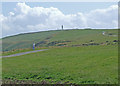
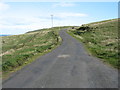
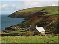
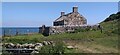
The southern of two sets of defensive earthworks across Scotland's most southerly point, the Mull Of Galloway. br>
For more information see Canmore ID 61051 which tells us the earthwork runs from NX 14192 30645 to NX 14523 30852.
An excavation was carried out in 2000 which: "A detailed measured survey of the earthworks was undertaken, and a vegetation survey was also carried out by the Natural Resource Consultancy. Sample geophysical survey was undertaken across the earthworks in an attempt to identify internal structural components." For more details click on the link for the Canmore record.
You may be viewing yesterday's version of this page. To see the most up to date information please register for a free account.
 (PID:259918)")
 (PID:259917)")
 (PID:259919)")
")
Do not use the above information on other web sites or publications without permission of the contributor.
Nearby Images from Geograph Britain and Ireland:
©2009(licence)
©2014(licence)
©2007(licence)
©2021(licence)
©2021(licence)
The above images may not be of the site on this page, they are loaded from Geograph.
Please Submit an Image of this site or go out and take one for us!
Click here to see more info for this site
Nearby sites
Key: Red: member's photo, Blue: 3rd party photo, Yellow: other image, Green: no photo - please go there and take one, Grey: site destroyed
Download sites to:
KML (Google Earth)
GPX (GPS waypoints)
CSV (Garmin/Navman)
CSV (Excel)
To unlock full downloads you need to sign up as a Contributory Member. Otherwise downloads are limited to 50 sites.
Turn off the page maps and other distractions
Nearby sites listing. In the following links * = Image available
187m NE 46° Mull Of Galloway Earthworks* Ancient Village or Settlement (NX14523086)
854m N 358° Chapel Wells (Mull of Galloway) Holy Well or Sacred Spring (NX14393159)
1.1km WNW 296° West Cairngaan stone* Standing Stone (Menhir) (NX13393126)
1.3km E 100° Lagvag Cairn* Cairn (NX15683044)
1.5km WNW 304° Kibbertie Kite Well (West Cairngaan) Holy Well or Sacred Spring (NX13193160)
4.5km NW 312° Muntloch Well (Drummore) Holy Well or Sacred Spring (NX11153384)
5.6km NNW 347° Lady Well (Low Drummore) Holy Well or Sacred Spring (NX13303626)
6.4km WNW 299° Crammag Head* Promontory Fort / Cliff Castle (NX08913404)
6.4km NNW 340° Core Hill* Hillfort (NX12433686)
6.7km NW 321° Cairn Fell* Cairn (NX10333612)
7.5km NNW 345° Kilstay* Standing Stone (Menhir) (NX1273738072)
9.3km NNW 337° Inchmulloch Hill* Standing Stone (Menhir) (NX1113739421)
9.6km NNW 343° St Bride's Well (Kirkmaiden Parish) Holy Well or Sacred Spring (NX1240)
10.7km NNW 346° Terally Bay* Standing Stone (Menhir) (NX12284127)
11.4km NNW 345° Chipperdingan Well (New England Bay) Holy Well or Sacred Spring (NX11904190)
13.0km NNW 336° St Mary's Well (Logan) Holy Well or Sacred Spring (NX096428)
13.4km NNW 340° Logan House* Standing Stone (Menhir) (NX10224354)
14.7km NNW 330° Grennan Point* Promontory Fort / Cliff Castle (NX07604377)
15.9km NNW 329° Doon Castle (Broch)* Broch or Nuraghe (NX0670244683)
17.9km NNW 334° Craigencroy* Cairn (NX07064711)
18.7km NNW 340° Cairnweil standing stone* Standing Stone (Menhir) (NX0863748556)
18.7km NNW 338° Kirkmadrine Church Stones* Early Christian Sculptured Stone (NX0801448389)
19.3km NNW 335° Mid Float E* Standing Stone (Menhir) (NX06804851)
19.3km NNW 334° Mid Float W* Natural Stone / Erratic / Other Natural Feature (NX06584844)
19.8km NNW 335° Whirlpool* Standing Stone (Menhir) (NX06624898)
View more nearby sites and additional images


 We would like to know more about this location. Please feel free to add a brief description and any relevant information in your own language.
 Wir möchten mehr über diese Stätte erfahren. Bitte zögern Sie nicht, eine kurze Beschreibung und relevante Informationen in Deutsch hinzuzufügen.
 Nous aimerions en savoir encore un peu sur les lieux. S'il vous plaît n'hesitez pas à ajouter une courte description et tous les renseignements pertinents dans votre propre langue.
 Quisieramos informarnos un poco más de las lugares. No dude en añadir una breve descripción y otros datos relevantes en su propio idioma.