

, Aubrey Burl")
<< Our Photo Pages >> West Taphouse Ridge Barrow Cemetery (A) - Barrow Cemetery in England in Cornwall
Submitted by mikeaitch on Sunday, 01 May 2011 Page Views: 3884
Neolithic and Bronze AgeSite Name: West Taphouse Ridge Barrow Cemetery (A)Country: England
NOTE: This site is 1.233 km away from the location you searched for.
County: Cornwall Type: Barrow Cemetery
Nearest Village: West Taphouse
Map Ref: SX143632
Latitude: 50.439197N Longitude: 4.616498W
Condition:
| 5 | Perfect |
| 4 | Almost Perfect |
| 3 | Reasonable but with some damage |
| 2 | Ruined but still recognisable as an ancient site |
| 1 | Pretty much destroyed, possibly visible as crop marks |
| 0 | No data. |
| -1 | Completely destroyed |
| 5 | Superb |
| 4 | Good |
| 3 | Ordinary |
| 2 | Not Good |
| 1 | Awful |
| 0 | No data. |
| 5 | Can be driven to, probably with disabled access |
| 4 | Short walk on a footpath |
| 3 | Requiring a bit more of a walk |
| 2 | A long walk |
| 1 | In the middle of nowhere, a nightmare to find |
| 0 | No data. |
| 5 | co-ordinates taken by GPS or official recorded co-ordinates |
| 4 | co-ordinates scaled from a detailed map |
| 3 | co-ordinates scaled from a bad map |
| 2 | co-ordinates of the nearest village |
| 1 | co-ordinates of the nearest town |
| 0 | no data |
Internal Links:
External Links:
 (PID:76529)")
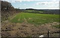
West Taphouse Barrow Cemetery (A) is a group 4 barrows the tallest of which is 5m high, one is ploughed away and one is barely visible. The barrows are aligned roughly east west on Taphouse ridge with wonderful views of this part of Cornwall.
MONUMENT NO. 432708 Pastscape
You may be viewing yesterday's version of this page. To see the most up to date information please register for a free account.
 (PID:76530)")
Do not use the above information on other web sites or publications without permission of the contributor.
MikeAitch has found this location on Google Street View:
Nearby Images from Geograph Britain and Ireland:
©2022(licence)
©2011(licence)
©2007(licence)
©2011(licence)
©2016(licence)
The above images may not be of the site on this page, they are loaded from Geograph.
Please Submit an Image of this site or go out and take one for us!
Click here to see more info for this site
Nearby sites
Key: Red: member's photo, Blue: 3rd party photo, Yellow: other image, Green: no photo - please go there and take one, Grey: site destroyed
Download sites to:
KML (Google Earth)
GPX (GPS waypoints)
CSV (Garmin/Navman)
CSV (Excel)
To unlock full downloads you need to sign up as a Contributory Member. Otherwise downloads are limited to 50 sites.
Turn off the page maps and other distractions
Nearby sites listing. In the following links * = Image available
315m WNW 286° West Taphouse Barrow Cemetery (B)* Barrow Cemetery (SX140633)
2.4km W 275° Bofarnel down* Barrow Cemetery (SX119635)
2.9km E 90° Middle Taphouse Round Barrow (A)* Round Barrow(s) (SX172631)
2.9km ENE 61° Largin Castle Hillfort (SX16896454)
3.3km ESE 102° Middle Taphouse Round Barrow (B)* Round Barrow(s) (SX175624)
3.6km SSW 202° St Nectan Church Cross* Ancient Cross (SX128599)
4.7km N 349° Welltown Stones* Early Christian Sculptured Stone (SX136678)
5.5km NNE 33° Crowpound Menhir* Standing Stone (Menhir) (SX17446773)
5.8km W 272° Lanhydrock* Ancient Cross (SX085636)
5.8km NNW 346° Treslea Cross* Ancient Cross (SX131689)
5.8km NNW 338° Cardinham Churchyard* Ancient Cross (SX123687)
5.9km SE 128° Bury Camp (Cornwall)* Hillfort (SX188594)
5.9km W 272° Holy Well (Lanhydrock)* Holy Well or Sacred Spring (SX084636)
6.0km WNW 293° Carminow Cross Ancient Cross (SX08846569)
6.3km NE 41° St Neot Crosses* Ancient Cross (SX1859567843)
6.3km NE 37° St Neot's Well (St Neot)* Holy Well or Sacred Spring (SX183681)
6.3km WNW 292° Castle Canyke* Ancient Village or Settlement (SX085658)
6.5km NNW 342° Trezance* Holy Well or Sacred Spring (SX125694)
6.5km N 351° Bury Castle Hill Fort* Hillfort (SX13526961)
6.8km SW 231° Pelyn Cross* Ancient Cross (SX089591)
7.2km W 264° Lesquite Quoit* Burial Chamber or Dolmen (SX07076276)
7.4km NW 308° Callywith Cross Early Christian Sculptured Stone (SX08566794)
7.6km WNW 296° St Petroc's Holy Well* Holy Well or Sacred Spring (SX07566671)
7.6km W 264° Lesquite Cross* Ancient Cross (SX06666269)
7.6km NNE 27° Trebinnick menhir* Standing Stone (Menhir) (SX180699)
View more nearby sites and additional images


 We would like to know more about this location. Please feel free to add a brief description and any relevant information in your own language.
 Wir möchten mehr über diese Stätte erfahren. Bitte zögern Sie nicht, eine kurze Beschreibung und relevante Informationen in Deutsch hinzuzufügen.
 Nous aimerions en savoir encore un peu sur les lieux. S'il vous plaît n'hesitez pas à ajouter une courte description et tous les renseignements pertinents dans votre propre langue.
 Quisieramos informarnos un poco más de las lugares. No dude en añadir una breve descripción y otros datos relevantes en su propio idioma.