


<< Our Photo Pages >> Laganabeastie West - Cairn in Scotland in Dumfries and Galloway
Submitted by markj99 on Tuesday, 21 July 2020 Page Views: 461
Neolithic and Bronze AgeSite Name: Laganabeastie WestCountry: Scotland County: Dumfries and Galloway Type: Cairn
Nearest Town: Stranraer Nearest Village: Cairnryan
Map Ref: NX13007271
Latitude: 55.013695N Longitude: 4.92619W
Condition:
| 5 | Perfect |
| 4 | Almost Perfect |
| 3 | Reasonable but with some damage |
| 2 | Ruined but still recognisable as an ancient site |
| 1 | Pretty much destroyed, possibly visible as crop marks |
| 0 | No data. |
| -1 | Completely destroyed |
| 5 | Superb |
| 4 | Good |
| 3 | Ordinary |
| 2 | Not Good |
| 1 | Awful |
| 0 | No data. |
| 5 | Can be driven to, probably with disabled access |
| 4 | Short walk on a footpath |
| 3 | Requiring a bit more of a walk |
| 2 | A long walk |
| 1 | In the middle of nowhere, a nightmare to find |
| 0 | No data. |
| 5 | co-ordinates taken by GPS or official recorded co-ordinates |
| 4 | co-ordinates scaled from a detailed map |
| 3 | co-ordinates scaled from a bad map |
| 2 | co-ordinates of the nearest village |
| 1 | co-ordinates of the nearest town |
| 0 | no data |
Internal Links:
External Links:
")
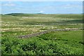
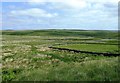
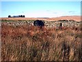
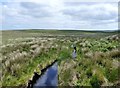
Laganbeastie West is an undisturbed cairn listed as Canmore ID 61881. It is around 20 yards EW axis by 2 yards high , however, it is covered in grass with stones only visible on the summit. It’s possible that Laganabeastie Cairns East & West would been twins in the prehistoric landscape.
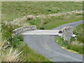
Directions: Take the un-signposted single track road 400 yards N of the Innermessan Junction on the A77 to Stranraer. Continue for 5 miles across moorland until you reach Penwhirn Reservoir and Filter Station. Take the next L across a bridge just after the Filter Station. This is a dead end single track road leading to Lagafater Lodge. Follow this narrow road for 2.5 miles until you reach an exposed stone bridge. Park in the next passing place. The Laganabeastie Cairns can be seen on the R in a rough pasture surrounded by a dry stane dyke. If you reach a Private Road sign you have gone too far. Turn around and the cairns will be on your L after around 500 yards.
You may be viewing yesterday's version of this page. To see the most up to date information please register for a free account.
")
")
")
Do not use the above information on other web sites or publications without permission of the contributor.
Nearby Images from Geograph Britain and Ireland:
©2013(licence)
©2013(licence)
©2006(licence)
©2013(licence)
©2009(licence)
The above images may not be of the site on this page, they are loaded from Geograph.
Please Submit an Image of this site or go out and take one for us!
Click here to see more info for this site
Nearby sites
Key: Red: member's photo, Blue: 3rd party photo, Yellow: other image, Green: no photo - please go there and take one, Grey: site destroyed
Download sites to:
KML (Google Earth)
GPX (GPS waypoints)
CSV (Garmin/Navman)
CSV (Excel)
To unlock full downloads you need to sign up as a Contributory Member. Otherwise downloads are limited to 50 sites.
Turn off the page maps and other distractions
Nearby sites listing. In the following links * = Image available
50m E 88° Laganbeastie East* Cairn (NX13057271)
788m SSE 155° Grey Hill (Shennas)* Cairn (NX13307198)
2.1km SW 236° Drumanwherran S Cairn Cemetery* Cairn (NX11207160)
2.1km WSW 251° Drumanwherran N* Cairn (NX10967212)
2.6km W 276° Friar's Kirk SE* Cairn (NX10407308)
2.8km WSW 247° Claywarnies Cairn* Cairn (NX10347171)
2.8km SW 224° Brockloch Fell* Cairn (NX10947075)
2.8km W 278° Friar's Kirk NW* Cairn (NX10197322)
3.8km S 186° Diddles Hill Cairn* Cairn (NX12446896)
4.6km SSW 194° Drumacissock North Cairn* Cairn (NX11706827)
4.7km SSW 194° Drumacissock South Cairn* Cairn (NX11676818)
4.9km WSW 257° Long Tom (Cairnryan)* Standing Stone (Menhir) (NX08167183)
4.9km SE 146° Kilfeddar Farm* Cairn (NX15626852)
5.1km ENE 58° Cairn Kenny* Passage Grave (NX17467525)
5.2km ENE 63° Markdhu White Cairn* Cairn (NX17807486)
5.6km SE 142° Altigoukie Burn Cairn* Cairn (NX16266817)
5.6km SSE 157° Cairnerzean Farm NE* Cairn (NX14996748)
5.6km SSE 157° Cairnerzean Farm SW* Cairn (NX14986747)
5.7km SE 142° Altigoukie Burn Burnt Mound* Misc. Earthwork (NX16336811)
5.8km SE 124° Craigbirnoch Central NW Cairn* Cairn (NX17656925)
5.9km SE 124° Craigbirnoch Central SE Cairn* Cairn (NX17706920)
5.9km ESE 121° Craigbirnoch NW Cairn* Cairn (NX17946944)
6.0km ESE 121° Craigbirnoch NE Cairn* Cairn (NX18026940)
6.0km SSE 160° Lingdowey Burn E* Cairn (NX14806698)
6.1km S 172° Cairnerzean Fell Summit* Cairn (NX13606668)
View more nearby sites and additional images


 We would like to know more about this location. Please feel free to add a brief description and any relevant information in your own language.
 Wir möchten mehr über diese Stätte erfahren. Bitte zögern Sie nicht, eine kurze Beschreibung und relevante Informationen in Deutsch hinzuzufügen.
 Nous aimerions en savoir encore un peu sur les lieux. S'il vous plaît n'hesitez pas à ajouter une courte description et tous les renseignements pertinents dans votre propre langue.
 Quisieramos informarnos un poco más de las lugares. No dude en añadir una breve descripción y otros datos relevantes en su propio idioma.