


<< Our Photo Pages >> Gumfreston Holy Wells - Holy Well or Sacred Spring in Wales in Pembrokeshire
Submitted by HOLYWELl on Friday, 24 May 2019 Page Views: 12267
Springs and Holy WellsSite Name: Gumfreston Holy WellsCountry: Wales County: Pembrokeshire Type: Holy Well or Sacred Spring
Nearest Town: Tenby Nearest Village: Gumfreston
Map Ref: SN1093001084
Latitude: 51.676616N Longitude: 4.735991W
Condition:
| 5 | Perfect |
| 4 | Almost Perfect |
| 3 | Reasonable but with some damage |
| 2 | Ruined but still recognisable as an ancient site |
| 1 | Pretty much destroyed, possibly visible as crop marks |
| 0 | No data. |
| -1 | Completely destroyed |
| 5 | Superb |
| 4 | Good |
| 3 | Ordinary |
| 2 | Not Good |
| 1 | Awful |
| 0 | No data. |
| 5 | Can be driven to, probably with disabled access |
| 4 | Short walk on a footpath |
| 3 | Requiring a bit more of a walk |
| 2 | A long walk |
| 1 | In the middle of nowhere, a nightmare to find |
| 0 | No data. |
| 5 | co-ordinates taken by GPS or official recorded co-ordinates |
| 4 | co-ordinates scaled from a detailed map |
| 3 | co-ordinates scaled from a bad map |
| 2 | co-ordinates of the nearest village |
| 1 | co-ordinates of the nearest town |
| 0 | no data |
Internal Links:
External Links:
I have visited· I would like to visit
Akasha70 would like to visit
")
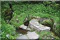
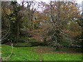
Certainly as can be seen by the photo one is more chalybeate than the others (it certainly tasted it). The wells do not appear to have gained a dedication but were much frequented in pilgrim times.
When sea bathing was established at Tenby people would send for the water for a range of ailments. In later years pins were thrown in and even more recently candles are lit and placed on the wells. A very peaceful place.
More from Coflein: There are three wells in a small group, apparently originating in two natural springs. It was customary down to the 17th century for bent pins to be dropped into the water to mark the end of Lent; the practice was called 'throwing Lent away'. The reputation of the wells continued down to the 19th; Gosse, who visited in 1861, says that traditionally the lowest of the three had a healing reputation, and leading down to this there was a worn masonry step. Source: Coflein
You may be viewing yesterday's version of this page. To see the most up to date information please register for a free account.
")
")
")
")
Do not use the above information on other web sites or publications without permission of the contributor.
Nearby Images from Geograph Britain and Ireland:
©2015(licence)
©2015(licence)
©2015(licence)
©2015(licence)
©2015(licence)
The above images may not be of the site on this page, they are loaded from Geograph.
Please Submit an Image of this site or go out and take one for us!
Click here to see more info for this site
Nearby sites
Key: Red: member's photo, Blue: 3rd party photo, Yellow: other image, Green: no photo - please go there and take one, Grey: site destroyed
Download sites to:
KML (Google Earth)
GPX (GPS waypoints)
CSV (Garmin/Navman)
CSV (Excel)
To unlock full downloads you need to sign up as a Contributory Member. Otherwise downloads are limited to 50 sites.
Turn off the page maps and other distractions
Nearby sites listing. In the following links * = Image available
806m SSE 159° Hoyle's Mouth Cave* Cave or Rock Shelter (SN11190032)
1.1km SSE 166° Longberry Bank Cave* Cave or Rock Shelter (SS11179996)
2.0km SSE 156° St Deiniols Well* Holy Well or Sacred Spring (SS117992)
2.1km SSE 154° Penally Celtic Cross Ancient Cross (SS1177799180)
2.1km E 96° St John's Well (Tenby)* Holy Well or Sacred Spring (SN130008)
2.7km E 100° Tenby Museum Museum (SN136005)
2.8km SSE 167° Giltar cliff barrow* Round Barrow(s) (SS1145298352)
3.1km SSW 207° Lydstep Submerged Forest and Mesolithic Footprints Not Known (by us) (SS0944998404)
3.7km WSW 252° Norchard Beacon* Barrow Cemetery (SN07310008)
3.9km SSE 159° St Margaret's Island* Ancient Village or Settlement (SS12209736)
4.4km SSE 149° Eel Point* Cave or Rock Shelter (SS13049723)
5.2km WNW 300° Cuckoo Stones* Chambered Tomb (SN065039)
5.3km SE 137° Potter's Cave Cave or Rock Shelter (SS14369707)
5.4km SSE 153° West Beacon Barrow Round Barrow(s) (SS13239623)
5.5km SE 136° Nanna's Cave* Cave or Rock Shelter (SS14589697)
5.7km SE 137° Skull Cave Cave or Rock Shelter (SS14679680)
5.7km SE 145° Caldey Ogham Stone* Early Christian Sculptured Stone (SS14089628)
6.0km SE 136° Daylight Rock Mesolithic Site Cave or Rock Shelter (SS149966)
6.3km SW 231° King's Quoit, Manorbier* Burial Chamber or Dolmen (SS05939728)
6.8km WNW 291° Carew High Cross* Ancient Cross (SN0467503707)
7.7km NE 40° Amroth Submerged Forest Not Known (by us) (SN16070678)
7.7km NE 40° Amroth Submerged Forest Not Known (by us) (SN16070678)
9.1km NNE 22° The Longstone (Pembrokeshire)* Standing Stone (Menhir) (SN146094)
9.8km NNE 22° Longstone Camp* Hillfort (SN14990996)
10.4km N 360° Templeton Cross* Early Christian Sculptured Stone (SN1131011528)
View more nearby sites and additional images


 We would like to know more about this location. Please feel free to add a brief description and any relevant information in your own language.
 Wir möchten mehr über diese Stätte erfahren. Bitte zögern Sie nicht, eine kurze Beschreibung und relevante Informationen in Deutsch hinzuzufügen.
 Nous aimerions en savoir encore un peu sur les lieux. S'il vous plaît n'hesitez pas à ajouter une courte description et tous les renseignements pertinents dans votre propre langue.
 Quisieramos informarnos un poco más de las lugares. No dude en añadir una breve descripción y otros datos relevantes en su propio idioma.