


<< Our Photo Pages >> Beinn Ghobhlach Standing Stone - Standing Stone (Menhir) in Scotland in Highlands
Submitted by andy_h on Saturday, 26 August 2006 Page Views: 6189
Neolithic and Bronze AgeSite Name: Beinn Ghobhlach Standing StoneCountry: Scotland County: Highlands Type: Standing Stone (Menhir)
Map Ref: NH080915
Latitude: 57.871567N Longitude: 5.238971W
Condition:
| 5 | Perfect |
| 4 | Almost Perfect |
| 3 | Reasonable but with some damage |
| 2 | Ruined but still recognisable as an ancient site |
| 1 | Pretty much destroyed, possibly visible as crop marks |
| 0 | No data. |
| -1 | Completely destroyed |
| 5 | Superb |
| 4 | Good |
| 3 | Ordinary |
| 2 | Not Good |
| 1 | Awful |
| 0 | No data. |
| 5 | Can be driven to, probably with disabled access |
| 4 | Short walk on a footpath |
| 3 | Requiring a bit more of a walk |
| 2 | A long walk |
| 1 | In the middle of nowhere, a nightmare to find |
| 0 | No data. |
| 5 | co-ordinates taken by GPS or official recorded co-ordinates |
| 4 | co-ordinates scaled from a detailed map |
| 3 | co-ordinates scaled from a bad map |
| 2 | co-ordinates of the nearest village |
| 1 | co-ordinates of the nearest town |
| 0 | no data |
Internal Links:
External Links:
I have visited· I would like to visit
SolarMegalith would like to visit
")
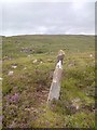
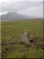
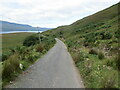
An indistinct track leads from a wooden gate to the stone, which is only just visible from the single track road from Dundonnel to Badrallach.
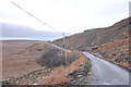
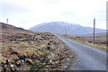
The drive here is excellent with amazing views, steep rocky hillsides and every chance of seeing Buzzards at close quarters.
You may be viewing yesterday's version of this page. To see the most up to date information please register for a free account.
")
")
")
Do not use the above information on other web sites or publications without permission of the contributor.
Nearby Images from Geograph Britain and Ireland:
©2013(licence)
©2013(licence)
©2011(licence)
©2011(licence)
©2021(licence)
The above images may not be of the site on this page, they are loaded from Geograph.
Please Submit an Image of this site or go out and take one for us!
Click here to see more info for this site
Nearby sites
Key: Red: member's photo, Blue: 3rd party photo, Yellow: other image, Green: no photo - please go there and take one, Grey: site destroyed
Download sites to:
KML (Google Earth)
GPX (GPS waypoints)
CSV (Garmin/Navman)
CSV (Excel)
To unlock full downloads you need to sign up as a Contributory Member. Otherwise downloads are limited to 50 sites.
Turn off the page maps and other distractions
Nearby sites listing. In the following links * = Image available
6.2km E 89° Dun Lagaidh* Stone Fort or Dun (NH14239135)
7.0km E 99° Dun An Ruigh Ruadh* Stone Fort or Dun (NH14939008)
7.1km SE 143° Bruthach Na Garbh Choille Ancient Village or Settlement (NH120856)
7.6km N 9° Isle Martin Cross Stone* Ancient Cross (NH096989)
9.0km E 96° Allt Raon A'Chroisg Broch or Nuraghe (NH16959008)
9.8km NNE 16° Dun Canna* Stone Fort or Dun (NC11160080)
11.2km W 275° Stones near Mungasdale Natural Stone / Erratic / Other Natural Feature (NG9686393111)
13.5km NE 36° An Dun, Strath Canaird Stone Fort or Dun (NC16530196)
16.2km NNW 339° Achlochan Broch* Broch or Nuraghe (NC029069)
19.3km W 280° Mellon Udrigle Hut Circle* Ancient Village or Settlement (NG891957)
23.1km NNW 342° Brae of Achnahaird Stone Fort or Dun (NC01701380)
24.0km N 354° Inverpolly Stone Fort or Dun (NC06611551)
24.2km SW 215° Isle Maree* Holy Well or Sacred Spring (NG93107236)
24.3km WSW 241° Inverewe* Class I Pictish Symbol Stone (NG860809)
25.0km NNE 32° Glacbain* Cairn (NC2231112011)
26.0km NE 35° Ledmore* Chambered Cairn (NC23821215)
26.5km NNE 33° Cam Loch B Chambered Cairn (NC23431314)
26.5km NNE 33° Cam Loch A Cairn (NC23501312)
26.6km NE 39° Loch Borralan Crannog* Crannog (NC25741138)
26.6km NE 40° Loch Borralan West* Chambered Cairn (NC2603811142)
26.8km NE 40° Loch Borralan East* Chambered Cairn (NC26241118)
26.9km NE 41° Altnacealgach* Chambered Cairn (NC2652811033)
27.6km NE 50° Cnoc Chaornaidh North West* Chambered Cairn (NC299084)
27.6km NE 51° Cnoc Chaornaidh South-east* Chambered Cairn (NC30320793)
27.7km NE 50° Cnoc Chaornaidh Central* Cairn (NC30170818)
View more nearby sites and additional images


 We would like to know more about this location. Please feel free to add a brief description and any relevant information in your own language.
 Wir möchten mehr über diese Stätte erfahren. Bitte zögern Sie nicht, eine kurze Beschreibung und relevante Informationen in Deutsch hinzuzufügen.
 Nous aimerions en savoir encore un peu sur les lieux. S'il vous plaît n'hesitez pas à ajouter une courte description et tous les renseignements pertinents dans votre propre langue.
 Quisieramos informarnos un poco más de las lugares. No dude en añadir una breve descripción y otros datos relevantes en su propio idioma.