


<< Our Photo Pages >> Tor of Craigoch - Hillfort in Scotland in Dumfries and Galloway
Submitted by andyturner on Thursday, 03 June 2004 Page Views: 8081
Iron Age and Later PrehistorySite Name: Tor of CraigochCountry: Scotland
NOTE: This site is 1.1 km away from the location you searched for.
County: Dumfries and Galloway Type: Hillfort
Nearest Town: Stranraer Nearest Village: Leswalt
Map Ref: NX00856464 Landranger Map Number: 82
Latitude: 54.936568N Longitude: 5.110304W
Condition:
| 5 | Perfect |
| 4 | Almost Perfect |
| 3 | Reasonable but with some damage |
| 2 | Ruined but still recognisable as an ancient site |
| 1 | Pretty much destroyed, possibly visible as crop marks |
| 0 | No data. |
| -1 | Completely destroyed |
| 5 | Superb |
| 4 | Good |
| 3 | Ordinary |
| 2 | Not Good |
| 1 | Awful |
| 0 | No data. |
| 5 | Can be driven to, probably with disabled access |
| 4 | Short walk on a footpath |
| 3 | Requiring a bit more of a walk |
| 2 | A long walk |
| 1 | In the middle of nowhere, a nightmare to find |
| 0 | No data. |
| 5 | co-ordinates taken by GPS or official recorded co-ordinates |
| 4 | co-ordinates scaled from a detailed map |
| 3 | co-ordinates scaled from a bad map |
| 2 | co-ordinates of the nearest village |
| 1 | co-ordinates of the nearest town |
| 0 | no data |
Internal Links:
External Links:
I have visited· I would like to visit
drolaf visited on 30th Mar 2022 - their rating: Cond: 3 Amb: 5 Access: 4 amazing views from the top-of Ireland, the Rhinns, Loch Ryan, Ailsa Craig, the hills inland, Arran and Kintyre. A visit to the Rhinns really emphasises that the water linked all these lands as one.
h_fenton have visited here
")
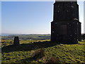
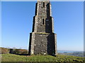
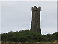
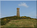
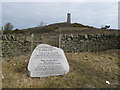
From Stranraer, go through the centre of Leswalt village and up Kirkland Hill. The Tor of Craigoch is topped with the castellated Agnew Monument, built in 1850 in memory of Sir Andrew Agnew. As you follow the stepped footpath up to the monument, you cross the collapsed walls of the Iron Age hillfort, now visible as a spread of stones hidden among the gorse bushes.The views from the top of the hill, out along Loch Ryan to Ailsa Craig and Arran are spectacular.
For more information about the hillfort see Canmore ID 60830 and for the Sir Andrew Agnew Monument at NX 00843 64649 see Canmore ID 298303
Sir Andrew Agnew lived between 1793 and 1849 and was the 7th Baronet of Lochnaw.
The Canmore record for the fort holds field notes from 1953. A more recent visit in 1984 recorded: "This fort is situated on a small steep-sided hill known as the Tor of Craigoch, about 1km NW of Leswalt. The interior measures about 50m from NE to SW by 38m transversely, but the defences are almost totally obscured by dense thickets of gorse, brambles and rhodedendrons. Traces of two ramparts reduced to stony scarps about 0.6m in maximum height are visible on the S and NE and earlier reports (RCAHMS Survey of Marginal Lands; OS Field Report) record two additional ramparts on the SW. The inner of the two outer ramparts extends round the E, but the portion of it visible on the NE appears to be a natural terrace. The position of the entrance is uncertain, although a gap in the defences has been noted on the NE."
You may be viewing yesterday's version of this page. To see the most up to date information please register for a free account.
")
")
")
")
Do not use the above information on other web sites or publications without permission of the contributor.
Nearby Images from Geograph Britain and Ireland:
©2013(licence)
©2013(licence)
©2013(licence)
©2007(licence)
©2013(licence)
The above images may not be of the site on this page, they are loaded from Geograph.
Please Submit an Image of this site or go out and take one for us!
Click here to see more info for this site
Nearby sites
Key: Red: member's photo, Blue: 3rd party photo, Yellow: other image, Green: no photo - please go there and take one, Grey: site destroyed
Download sites to:
KML (Google Earth)
GPX (GPS waypoints)
CSV (Garmin/Navman)
CSV (Excel)
To unlock full downloads you need to sign up as a Contributory Member. Otherwise downloads are limited to 50 sites.
Turn off the page maps and other distractions
Nearby sites listing. In the following links * = Image available
2.7km ENE 62° St Mary's Well (Kilmorie Chapel) Holy Well or Sacred Spring (NX03286578)
4.5km NNE 22° Kirkcolm Cross* Ancient Cross (NX0270568695)
4.7km NNE 25° St Columba's Well (Kirkcolm) Holy Well or Sacred Spring (NX03066880)
5.5km SSW 203° Culdees Holy Well (Knockaldie) Holy Well or Sacred Spring (NW985597)
6.0km SE 124° St John's Well (Stranraer) Holy Well or Sacred Spring (NX05646106)
6.1km N 353° St Bride's Well (Kirkcolm) Holy Well or Sacred Spring (NX00417073)
6.3km SE 124° Stranraer Museum* Museum (NX0594960839)
6.5km NW 325° North Cairn (Cairn Hill)* Cairn (NW97337014)
6.8km S 186° Knock and Maize* Standing Stone (Menhir) (NW9983057873)
7.5km SSE 165° Craigenlee Fell E* Cairn (NX02495728)
7.6km SSE 168° Craigenlee Fell W* Cairn (NX02155717)
7.7km S 184° Balmannoch Stone Circle (NX0057)
7.8km SSW 196° Killantringan Bay* Stone Fort or Dun (NW98365719)
8.1km NNW 344° St Columba's Well (Portmullin) Holy Well or Sacred Spring (NW98957256)
8.3km NE 38° Taxing Stone* Standing Stones (NX06237096)
8.7km ENE 75° Beoch Hill Cairn* Cairn (NX09336654)
8.8km ENE 73° White Cairn, Beoch Hill* Cairn (NX09436677)
8.9km S 185° St Kain's Well (Dunskey Glen) Holy Well or Sacred Spring (NW997558)
9.0km NNE 32° Haggstone Moor Circle Stone Circle (NX060720)
9.0km NNE 31° Gallop Hole* Cairn (NX0583872157)
9.0km SSE 154° Cairn Pat* Hillfort (NX04425632)
9.1km E 91° Teroy Fort* Broch or Nuraghe (NX0992364108)
9.3km NNE 29° Haggstone Moor Cairn* Cairn (NX0577672521)
9.8km NNE 33° Haggstone Moor Standing Stone* Standing Stone (Menhir) (NX0648572626)
9.8km ESE 120° Galla Hill* Misc. Earthwork (NX09205941)
View more nearby sites and additional images


 We would like to know more about this location. Please feel free to add a brief description and any relevant information in your own language.
 Wir möchten mehr über diese Stätte erfahren. Bitte zögern Sie nicht, eine kurze Beschreibung und relevante Informationen in Deutsch hinzuzufügen.
 Nous aimerions en savoir encore un peu sur les lieux. S'il vous plaît n'hesitez pas à ajouter une courte description et tous les renseignements pertinents dans votre propre langue.
 Quisieramos informarnos un poco más de las lugares. No dude en añadir una breve descripción y otros datos relevantes en su propio idioma.