


<< Our Photo Pages >> Trellwyn-fach Stone Pair - Standing Stones in Wales in Pembrokeshire
Submitted by vicky on Monday, 30 September 2002 Page Views: 4925
Neolithic and Bronze AgeSite Name: Trellwyn-fach Stone PairCountry: Wales County: Pembrokeshire Type: Standing Stones
Nearest Town: Fishguard Nearest Village: Llanychaer Bridge
Map Ref: SN001358 Landranger Map Number: 145
Latitude: 51.984595N Longitude: 4.912476W
Condition:
| 5 | Perfect |
| 4 | Almost Perfect |
| 3 | Reasonable but with some damage |
| 2 | Ruined but still recognisable as an ancient site |
| 1 | Pretty much destroyed, possibly visible as crop marks |
| 0 | No data. |
| -1 | Completely destroyed |
| 5 | Superb |
| 4 | Good |
| 3 | Ordinary |
| 2 | Not Good |
| 1 | Awful |
| 0 | No data. |
| 5 | Can be driven to, probably with disabled access |
| 4 | Short walk on a footpath |
| 3 | Requiring a bit more of a walk |
| 2 | A long walk |
| 1 | In the middle of nowhere, a nightmare to find |
| 0 | No data. |
| 5 | co-ordinates taken by GPS or official recorded co-ordinates |
| 4 | co-ordinates scaled from a detailed map |
| 3 | co-ordinates scaled from a bad map |
| 2 | co-ordinates of the nearest village |
| 1 | co-ordinates of the nearest town |
| 0 | no data |
Internal Links:
External Links:
I have visited· I would like to visit
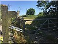
Anne T visited on 21st Aug 2014 - their rating: Cond: 3 Amb: 3 Access: 4 Trewynfach (Tre-llwyn Fawr) Stone Pair, Pembrokeshire: About 400 yards up the road from the Parc-y-meirw stones, just before reaching a house called Trellwyn, is an un-named farm to the south side of the road. On the map there are two standing stones marked, which stand very slightly to the west of the farm. Neither of the stones can be seen from the road. No-one appeared to be at the farm, and as the field gate was open, we walked along the field boundary for about 50 yards to see if we could spot them.
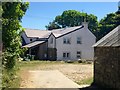
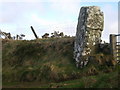
One of the stones has been used as a gatepost, in the field boundary between the farm and the first field to its west; the other is situated in the middle of the farmyard. Presumably the gatepost stone, which stands 1.4 metres high, has been relocated from its original site. The second stone is on private land, but looks taller than the stone being used as the gatepost.
I confess that after the Parc-y-Meirw stones and these, we looked at the gateposts of all the farms as we drove along, wondering if they were ‘recycled’ standing stones.
")
Have you visited this site? Please add a comment below.
You may be viewing yesterday's version of this page. To see the most up to date information please register for a free account.
")
")
Do not use the above information on other web sites or publications without permission of the contributor.
Nearby Images from Geograph Britain and Ireland:
©2018(licence)
©2018(licence)
©2009(licence)
©2010(licence)

©2008(licence)
The above images may not be of the site on this page, they are loaded from Geograph.
Please Submit an Image of this site or go out and take one for us!
Click here to see more info for this site
Nearby sites
Key: Red: member's photo, Blue: 3rd party photo, Yellow: other image, Green: no photo - please go there and take one, Grey: site destroyed
Download sites to:
KML (Google Earth)
GPX (GPS waypoints)
CSV (Garmin/Navman)
CSV (Excel)
To unlock full downloads you need to sign up as a Contributory Member. Otherwise downloads are limited to 50 sites.
Turn off the page maps and other distractions
Nearby sites listing. In the following links * = Image available
245m WNW 294° Parc y Meirw* Stone Row / Alignment (SM99883591)
316m SSE 159° Tre-llwyn Fawr* Standing Stone (Menhir) (SN002355)
652m ESE 106° Trellwyn-fach* Standing Stone (Menhir) (SN0072235599)
1.2km NNE 25° Mynydd Dinas Rocking Stone* Natural Stone / Erratic / Other Natural Feature (SN00653685)
1.4km W 272° Llanllawer Church* Early Christian Sculptured Stone (SM987359)
1.4km W 276° Llanllawer Holy Well* Holy Well or Sacred Spring (SM987360)
1.4km W 274° Llanllawer Inscribed Stones Early Christian Sculptured Stone (SM98673597)
1.6km WSW 249° Llanychaer Earthwork* Ancient Village or Settlement (SM986353)
1.6km SSW 212° Llanychaer Church* Early Christian Sculptured Stone (SM992345)
1.6km SE 140° Llanychllwydog Church* Early Christian Sculptured Stone (SN011345)
1.7km NE 40° Carn Enoch* Ancient Village or Settlement (SN01263705)
1.8km ENE 61° Glyn Gath Barrow* Round Barrow(s) (SN017366)
1.8km ENE 61° Glyn Gath Hut Circle* Ancient Village or Settlement (SN017366)
1.9km NNW 342° The Lady Stone* Standing Stone (Menhir) (SM9957537625)
2.1km SSE 146° The Pillar Stones* Early Christian Sculptured Stone (SN012340)
2.6km E 79° Mynydd Melyn Settlement 1 Ancient Village or Settlement (SN027362)
2.7km SE 127° Pontfaen Church Early Christian Sculptured Stone (SN022341)
2.9km ENE 76° Mynydd Melyn Stone* Standing Stone (Menhir) (SN029364)
2.9km ENE 76° Mynydd Melyn Cairn Cairn (SN029364)
3.0km N 11° Dinas Cross Stone* Standing Stone (Menhir) (SN00813875)
3.4km ESE 118° Allt Penrhiw Ancient Village or Settlement (SN030341)
3.5km ESE 119° Allt Pengegin isaf Ancient Village or Settlement (SN031340)
3.5km SSE 165° Mynydd Cilciffeth Cairn (SN009324)
3.5km ENE 68° Mynydd Melyn Settlement 2 Ancient Village or Settlement (SN034370)
3.8km ENE 77° Bedd Morris* Standing Stone (Menhir) (SN0381836502)
View more nearby sites and additional images


 We would like to know more about this location. Please feel free to add a brief description and any relevant information in your own language.
 Wir möchten mehr über diese Stätte erfahren. Bitte zögern Sie nicht, eine kurze Beschreibung und relevante Informationen in Deutsch hinzuzufügen.
 Nous aimerions en savoir encore un peu sur les lieux. S'il vous plaît n'hesitez pas à ajouter une courte description et tous les renseignements pertinents dans votre propre langue.
 Quisieramos informarnos un poco más de las lugares. No dude en añadir una breve descripción y otros datos relevantes en su propio idioma.