


<< Our Photo Pages >> Dunan Diarmaid - Hillfort in Scotland in Highlands
Submitted by uisdean on Friday, 27 April 2007 Page Views: 6216
Iron Age and Later PrehistorySite Name: Dunan DiarmaidCountry: Scotland County: Highlands Type: Hillfort
Nearest Village: Inverinate
Map Ref: NG93952071
Latitude: 57.230591N Longitude: 5.415401W
Condition:
| 5 | Perfect |
| 4 | Almost Perfect |
| 3 | Reasonable but with some damage |
| 2 | Ruined but still recognisable as an ancient site |
| 1 | Pretty much destroyed, possibly visible as crop marks |
| 0 | No data. |
| -1 | Completely destroyed |
| 5 | Superb |
| 4 | Good |
| 3 | Ordinary |
| 2 | Not Good |
| 1 | Awful |
| 0 | No data. |
| 5 | Can be driven to, probably with disabled access |
| 4 | Short walk on a footpath |
| 3 | Requiring a bit more of a walk |
| 2 | A long walk |
| 1 | In the middle of nowhere, a nightmare to find |
| 0 | No data. |
| 5 | co-ordinates taken by GPS or official recorded co-ordinates |
| 4 | co-ordinates scaled from a detailed map |
| 3 | co-ordinates scaled from a bad map |
| 2 | co-ordinates of the nearest village |
| 1 | co-ordinates of the nearest town |
| 0 | no data |
Internal Links:
External Links:
")
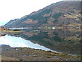
A dun overlooking the head of Loch Duich at NG 9395 2071. All that remains are grassy mounds covering the fallen stones of the walls. The dun was oval, some 75 feet by 45 feet; the entrance appears to have been on the south side facing Loch Duich where there is a deep hollow. The remains of a smaller circular enclosure some 18 feet in diameter, possibly modern, are in the interior.
The dun is named after Diarmid, the nephew of Fingal – see the entry on Diarmaid’s Grave, which is on the approaches to the Dun.
You may be viewing yesterday's version of this page. To see the most up to date information please register for a free account.
")
Do not use the above information on other web sites or publications without permission of the contributor.
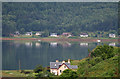
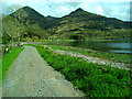
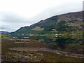
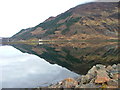
Nearby Images from Geograph Britain and Ireland:
©2015(licence)
©2007(licence)
©2020(licence)
©2011(licence)
©2007(licence)
The above images may not be of the site on this page, they are loaded from Geograph.
Please Submit an Image of this site or go out and take one for us!
Click here to see more info for this site
Nearby sites
Key: Red: member's photo, Blue: 3rd party photo, Yellow: other image, Green: no photo - please go there and take one, Grey: site destroyed
Download sites to:
KML (Google Earth)
GPX (GPS waypoints)
CSV (Garmin/Navman)
CSV (Excel)
To unlock full downloads you need to sign up as a Contributory Member. Otherwise downloads are limited to 50 sites.
Turn off the page maps and other distractions
Nearby sites listing. In the following links * = Image available
145m NNE 13° Diarmaid's Grave* Standing Stones (NG93992085)
698m NE 43° Tigh Geal* Rock Art (NG94452120)
1.4km ENE 57° Croe Bridge* Rock Art (NG95162141)
1.9km S 180° Cill Fhearchair* Standing Stone (Menhir) (NG93871879)
2.2km SSW 200° Sheil Henge* Henge (NG93081868)
3.0km ENE 68° Lienassie* Rock Art (NG968217)
5.5km WNW 291° Allt an Inbhir Souterrain* Souterrain (Fogou, Earth House) (NG88882296)
5.6km NW 310° Carr Brae* Rock Art (NG89782451)
5.7km S 173° Sheil Bridge* Ancient Village or Settlement (NG9438215035)
6.1km WNW 289° Torran a'Bharraich* Hillfort (NG88312296)
8.0km WNW 303° Totaig Cup Markings* Rock Art (NG87432536)
8.0km N 8° Faddoch* Rock Art (NG95452863)
8.3km NNW 327° Bard's Castle* Hillfort (NG89822790)
8.4km N 1° Camas Luinie* Rock Art (NG94492909)
8.4km WNW 298° Caisteal Grugaig* Broch or Nuraghe (NG86692508)
8.5km WNW 300° Dun Totaig (Loch Duich) Broch or Nuraghe (NG868253)
9.1km W 264° Serpent Mound (Scallasaig) Cairn (NG8484020288)
9.9km WSW 240° Grugaig Hut Circle* Ancient Village or Settlement (NG8517616131)
10.0km WSW 241° Balvraid Cup Marked Stone* Rock Art (NG84961635)
10.0km WSW 238° Dun Grugaig (Glenelg)* Broch or Nuraghe (NG85151591)
10.2km WSW 244° Balvraid Chambered Cairn* Chambered Cairn (NG8452416627)
10.6km WSW 245° Balvraid Farm Cup Marked Stone* Rock Art (NG84081667)
11.1km WSW 249° Dun Troddan* Broch or Nuraghe (NG834172)
11.3km NW 305° Dun Gleann Udalain Stone Fort or Dun (NG85062773)
11.3km WSW 249° Corrary Prehistoric Site* Cairn (NG83121725)
View more nearby sites and additional images


 We would like to know more about this location. Please feel free to add a brief description and any relevant information in your own language.
 Wir möchten mehr über diese Stätte erfahren. Bitte zögern Sie nicht, eine kurze Beschreibung und relevante Informationen in Deutsch hinzuzufügen.
 Nous aimerions en savoir encore un peu sur les lieux. S'il vous plaît n'hesitez pas à ajouter une courte description et tous les renseignements pertinents dans votre propre langue.
 Quisieramos informarnos un poco más de las lugares. No dude en añadir una breve descripción y otros datos relevantes en su propio idioma.