

<< Our Photo Pages >> Shiskine - Stone Circle in Scotland in Isle of Arran
Submitted by Tom_Bullock on Sunday, 14 July 2002 Page Views: 5804
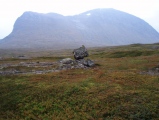
Neolithic and Bronze AgeSite Name: Shiskine Alternative Name: Ballymichael BridgeCountry: Scotland County: Isle of Arran Type: Stone Circle
Nearest Town: Shiskine Nearest Village: Ballymichael
Map Ref: NR92443225 Landranger Map Number: 68
Latitude: 55.539684N Longitude: 5.291124W
Condition:
| 5 | Perfect |
| 4 | Almost Perfect |
| 3 | Reasonable but with some damage |
| 2 | Ruined but still recognisable as an ancient site |
| 1 | Pretty much destroyed, possibly visible as crop marks |
| 0 | No data. |
| -1 | Completely destroyed |
| 5 | Superb |
| 4 | Good |
| 3 | Ordinary |
| 2 | Not Good |
| 1 | Awful |
| 0 | No data. |
| 5 | Can be driven to, probably with disabled access |
| 4 | Short walk on a footpath |
| 3 | Requiring a bit more of a walk |
| 2 | A long walk |
| 1 | In the middle of nowhere, a nightmare to find |
| 0 | No data. |
| 5 | co-ordinates taken by GPS or official recorded co-ordinates |
| 4 | co-ordinates scaled from a detailed map |
| 3 | co-ordinates scaled from a bad map |
| 2 | co-ordinates of the nearest village |
| 1 | co-ordinates of the nearest town |
| 0 | no data |
Internal Links:
External Links:
I have visited· I would like to visit
Bladup has visited here
")
Lies beyond a farm gate behind a Water works. Canmore site no. 39711.
You may be viewing yesterday's version of this page. To see the most up to date information please register for a free account.
")
Do not use the above information on other web sites or publications without permission of the contributor.
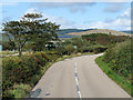
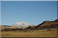
Nearby Images from Geograph Britain and Ireland:
©2008(licence)
©2012(licence)
©2020(licence)
©2019(licence)
©2010(licence)
The above images may not be of the site on this page, they are loaded from Geograph.
Please Submit an Image of this site or go out and take one for us!
Click here to see more info for this site
Nearby sites
Key: Red: member's photo, Blue: 3rd party photo, Yellow: other image, Green: no photo - please go there and take one, Grey: site destroyed
Download sites to:
KML (Google Earth)
GPX (GPS waypoints)
CSV (Garmin/Navman)
CSV (Excel)
To unlock full downloads you need to sign up as a Contributory Member. Otherwise downloads are limited to 50 sites.
Turn off the page maps and other distractions
Nearby sites listing. In the following links * = Image available
593m WNW 294° Ballymichael Bridge* Stone Circle (NR91913252)
1.1km SSE 163° Ballymichael Standing Stones* Standing Stones (NR92723119)
1.2km S 169° Uaigh Finnach* Standing Stone (Menhir) (NR9261631040)
1.2km W 275° Machrie Moor 6* Stone Circle (NR91223242)
1.2km W 274° Machrie Moor 1.* Stone Circle (NR91203240)
1.2km W 274° Machrie Moor 11 Timber Circle (NR912324)
1.3km W 275° Machrie Moor 2* Stone Circle (NR91143242)
1.4km W 275° Machrie Moor 3* Stone Circle (NR91013245)
1.4km W 272° Machrie Moor 4* Stone Circle (NR91003236)
1.6km W 271° Machrie Moor 5* Stone Circle (NR90883235)
1.7km W 271° Moss farm chambered cairn* Chambered Cairn (NR90753237)
1.8km W 276° Moss Farm Stone* Standing Stone (Menhir) (NR90643254)
1.9km W 271° Tormore 2* Chambered Cairn (NR90583237)
2.4km W 277° Machrie Moor 10* Stone Circle (NR90063265)
2.4km WSW 238° Tormore 1 Chambered Cairn (NR90313106)
2.7km SE 134° Clauchan Glen Standing Stone (Menhir) (NR94283029)
2.7km NW 326° Cnoc Na Ceille* Standing Stone (Menhir) (NR9101034553)
3.0km W 271° Tormore Farm Chambered Cairn (NR89453242)
3.3km NNW 328° Machrie Burn* Stone Circle (NR90843511)
3.3km WNW 292° Machriewaterfoot Standing Stone* Standing Stone (Menhir) (NR89453363)
3.4km NNE 25° Monyquil* Standing Stones (NR9405735284)
3.5km NNE 26° Moinechoill* Chambered Cairn (NR941353)
3.9km SW 227° Torbeg Cursus* Cursus (NR8950329741)
3.9km NW 305° Auchagallon* Stone Circle (NR89293464)
4.2km WSW 249° Kings Cave* Cave or Rock Shelter (NR88443092)
View more nearby sites and additional images


 We would like to know more about this location. Please feel free to add a brief description and any relevant information in your own language.
 Wir möchten mehr über diese Stätte erfahren. Bitte zögern Sie nicht, eine kurze Beschreibung und relevante Informationen in Deutsch hinzuzufügen.
 Nous aimerions en savoir encore un peu sur les lieux. S'il vous plaît n'hesitez pas à ajouter une courte description et tous les renseignements pertinents dans votre propre langue.
 Quisieramos informarnos un poco más de las lugares. No dude en añadir una breve descripción y otros datos relevantes en su propio idioma.