

<< Our Photo Pages >> Machrie Moor 10 - Stone Circle in Scotland in Isle of Arran
Submitted by kelpie on Friday, 02 August 2002 Page Views: 9469
Neolithic and Bronze AgeSite Name: Machrie Moor 10 Alternative Name: Moss Farm Road, Machrie XCountry: Scotland
NOTE: This site is 0.3 km away from the location you searched for.
County: Isle of Arran Type: Stone Circle
Nearest Town: Brodick Nearest Village: Blackwaterfoot
Map Ref: NR90063265 Landranger Map Number: 68
Latitude: 55.542254N Longitude: 5.329076W
Condition:
| 5 | Perfect |
| 4 | Almost Perfect |
| 3 | Reasonable but with some damage |
| 2 | Ruined but still recognisable as an ancient site |
| 1 | Pretty much destroyed, possibly visible as crop marks |
| 0 | No data. |
| -1 | Completely destroyed |
| 5 | Superb |
| 4 | Good |
| 3 | Ordinary |
| 2 | Not Good |
| 1 | Awful |
| 0 | No data. |
| 5 | Can be driven to, probably with disabled access |
| 4 | Short walk on a footpath |
| 3 | Requiring a bit more of a walk |
| 2 | A long walk |
| 1 | In the middle of nowhere, a nightmare to find |
| 0 | No data. |
| 5 | co-ordinates taken by GPS or official recorded co-ordinates |
| 4 | co-ordinates scaled from a detailed map |
| 3 | co-ordinates scaled from a bad map |
| 2 | co-ordinates of the nearest village |
| 1 | co-ordinates of the nearest town |
| 0 | no data |
Internal Links:
External Links:
I have visited· I would like to visit
drolaf visited on 10th May 2023 - their rating: Cond: 2 Access: 3
bishop_pam visited on 27th Apr 2023 - their rating: Cond: 5 Amb: 4 Access: 4
Catrinm visited on 1st Sep 2019 - their rating: Cond: 3 Amb: 4 Access: 3
AstroGeologist visited on 9th Aug 2018 - their rating: Cond: 3 Amb: 4 Access: 4 MM10 : MM 10 : This is the FIRST site you encounter when heading East from the Beach at Machrie. From the car park 'Machrie Moor 10' (Moss Farm Cairn Circle) is 760m away
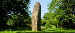
Remains of a 19m diameter Bronze Age Cairn and Stone Circle.
In 1861 the Cairn was completely encircled with with 70~100cm high Menhirs.
The Cairn has been robbed of much of it stones, and the outer kerb now consists only of 6 upright stones, with several now lying on their sides, and covered in grass.
The Cairn and Stone Circle may be destroyed, compared to it's original state, but the site still retains a special aura.
*Getting There ; Get the '322 bus' to Blackwaterfoot from the Ferry terminal at Brodick. It takes approx 45 minutes.
From Blackwaterfoot you can go directly to the Moor by following the A841 road which is a 5.5km walk (It took me about an hour on the way back)
Or you can take the scenic route which is 8.5km. The long way follow's the beach to Drumadoon Point, and then onto the Doon Hillfort, after exploring the Fort you walk along the beach path to Kings Caves (These part's of the journey are covered in log visits for these sites)
From the Caves you can go along the shore to Machrie Bay (which would have been shorter) but instead l followed the trail path up Torr Righ Mor (137m) and around the Pine forests on Torr Righ Beag (109m) until l reached to visitors car park. From here it's a 15 minute walk to the visitors car park at Machrie Moor.
This is the 1st site you encounter when coming from the car park.
SandyG visited on 22nd Aug 2017 - their rating: Cond: 4 Amb: 5 Access: 4
Andy B visited on 25th Aug 2016 - their rating: Cond: 3 Amb: 4 Access: 3
jeffrep visited on 2nd Jun 2013 - their rating: Cond: 3 Amb: 4 Access: 3
Richard13 visited on 1st Oct 2005 - their rating: Cond: 3 Amb: 4 Access: 3
BolshieBoris visited on 1st Aug 1996 - their rating: Cond: 4 Amb: 3 Access: 3
AngieLake kelpie have visited here
Average ratings for this site from all visit loggers: Condition: 3.33 Ambience: 4 Access: 3.33
")
A complex ring-cairn. Partial excavation of the SW quadrant in 1978-9 revealed that the cairn had been enclosed in a circle of sandstone slabs 21.8m in diameter. Only 5 of these remain. A 3m wide x 0.7m stoney bank surrounded this circle and within it was a low penannular cairn of heavy boulders capped with small angular pieces of red sandstone over which modern dumping of stones had occurred when the track was cut through the N part of the cairn.
More at Canmore
You may be viewing yesterday's version of this page. To see the most up to date information please register for a free account.
")
")
")
")
")
")
")
")
")
")
")
")
")
")
")
")
")
")
")
")
")
Do not use the above information on other web sites or publications without permission of the contributor.
Click here to see more info for this site
Nearby sites
Key: Red: member's photo, Blue: 3rd party photo, Yellow: other image, Green: no photo - please go there and take one, Grey: site destroyed
Download sites to:
KML (Google Earth)
GPX (GPS waypoints)
CSV (Garmin/Navman)
CSV (Excel)
To unlock full downloads you need to sign up as a Contributory Member. Otherwise downloads are limited to 50 sites.
![]()
![]()
Turn off the page maps and other distractions
Nearby sites listing. In the following links * = Image available
588m E 98° Moss Farm Stone* Standing Stone (Menhir) (NR90643254)
589m ESE 116° Tormore 2* Chambered Cairn (NR90583237)
650m WSW 247° Tormore Farm Chambered Cairn (NR89453242)
742m ESE 109° Moss farm chambered cairn* Chambered Cairn (NR90753237)
870m ESE 107° Machrie Moor 5* Stone Circle (NR90883235)
967m E 99° Machrie Moor 3* Stone Circle (NR91013245)
980m ESE 104° Machrie Moor 4* Stone Circle (NR91003236)
1.1km E 99° Machrie Moor 2* Stone Circle (NR91143242)
1.2km NW 325° Machriewaterfoot Standing Stone* Standing Stone (Menhir) (NR89453363)
1.2km E 100° Machrie Moor 1.* Stone Circle (NR91203240)
1.2km E 100° Machrie Moor 11 Timber Circle (NR912324)
1.2km E 98° Machrie Moor 6* Stone Circle (NR91223242)
1.6km SSE 168° Tormore 1 Chambered Cairn (NR90313106)
1.8km E 91° Ballymichael Bridge* Stone Circle (NR91913252)
2.1km NNE 24° Cnoc Na Ceille* Standing Stone (Menhir) (NR9101034553)
2.1km NNW 336° Auchagallon* Stone Circle (NR89293464)
2.4km SW 220° Kings Cave* Cave or Rock Shelter (NR88443092)
2.4km E 97° Shiskine* Stone Circle (NR92443225)
2.6km NNE 15° Machrie Burn* Stone Circle (NR90843511)
3.0km S 188° Torbeg Cursus* Cursus (NR8950329741)
3.0km ESE 120° Uaigh Finnach* Standing Stone (Menhir) (NR9261631040)
3.0km ESE 116° Ballymichael Standing Stones* Standing Stones (NR92723119)
3.5km SSW 201° Drumadoon Hillfort* Hillfort
3.7km SSW 200° Drummadoon Standing Stone* Standing Stone (Menhir) (NR8865629273)
3.7km SSW 200° Drumidoon* Stone Circle (NR886292)
View more nearby sites and additional images


 We would like to know more about this location. Please feel free to add a brief description and any relevant information in your own language.
 Wir möchten mehr über diese Stätte erfahren. Bitte zögern Sie nicht, eine kurze Beschreibung und relevante Informationen in Deutsch hinzuzufügen.
 Nous aimerions en savoir encore un peu sur les lieux. S'il vous plaît n'hesitez pas à ajouter une courte description et tous les renseignements pertinents dans votre propre langue.
 Quisieramos informarnos un poco más de las lugares. No dude en añadir una breve descripción y otros datos relevantes en su propio idioma.