 with our Megalithic Portal iPhone app")


<< Text Pages >> Gleann Udalain Cairn - Cairn in Scotland in Highlands
Submitted by SolarMegalith on Sunday, 08 May 2011 Page Views: 3717
Neolithic and Bronze AgeSite Name: Gleann Udalain Cairn Alternative Name: AuchtertyreCountry: Scotland County: Highlands Type: Cairn
Map Ref: NG85092942
Latitude: 57.304608N Longitude: 5.56943W
Condition:
| 5 | Perfect |
| 4 | Almost Perfect |
| 3 | Reasonable but with some damage |
| 2 | Ruined but still recognisable as an ancient site |
| 1 | Pretty much destroyed, possibly visible as crop marks |
| 0 | No data. |
| -1 | Completely destroyed |
| 5 | Superb |
| 4 | Good |
| 3 | Ordinary |
| 2 | Not Good |
| 1 | Awful |
| 0 | No data. |
| 5 | Can be driven to, probably with disabled access |
| 4 | Short walk on a footpath |
| 3 | Requiring a bit more of a walk |
| 2 | A long walk |
| 1 | In the middle of nowhere, a nightmare to find |
| 0 | No data. |
| 5 | co-ordinates taken by GPS or official recorded co-ordinates |
| 4 | co-ordinates scaled from a detailed map |
| 3 | co-ordinates scaled from a bad map |
| 2 | co-ordinates of the nearest village |
| 1 | co-ordinates of the nearest town |
| 0 | no data |
Internal Links:
External Links:
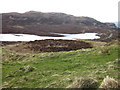
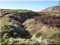
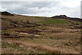
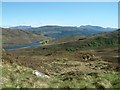
Cairn and possible henge in the Highlands
Well-preserved cairn surrounded with a bank.
Read More at ScotlandsPlaces and the Highland HER
"This site was visited by Roland Spencer-Jones of the North of Scotland Archaeological Society on the 12th of May 2014. The monument was noted as much the same as described by previous visitors. In addition Spencer-Jones noted a well defined gap in the bank in the WNW suggesting that this was an entrance. A less clearly defined break in the much reduced bank in the ESE was suggested as a second entrance exactly opposite the first. He suggested the site was a henge due to the central platform, ditch and bank although stated that it appeared to be bigger, higher and more outstanding than most henges in Highland."
Source: Highland HER
You may be viewing yesterday's version of this page. To see the most up to date information please register for a free account.
Do not use the above information on other web sites or publications without permission of the contributor.
Nearby Images from Geograph Britain and Ireland:
©2016(licence)
©2016(licence)
©2012(licence)
©2008(licence)
©2022(licence)
The above images may not be of the site on this page, they are loaded from Geograph.
Please Submit an Image of this site or go out and take one for us!
Click here to see more info for this site
Nearby sites
Key: Red: member's photo, Blue: 3rd party photo, Yellow: other image, Green: no photo - please go there and take one, Grey: site destroyed
Download sites to:
KML (Google Earth)
GPX (GPS waypoints)
CSV (Garmin/Navman)
CSV (Excel)
To unlock full downloads you need to sign up as a Contributory Member. Otherwise downloads are limited to 50 sites.
Turn off the page maps and other distractions
Nearby sites listing. In the following links * = Image available
1.7km S 178° Dun Gleann Udalain Stone Fort or Dun (NG85062773)
2.8km SW 222° Angels' Hill, Kirkton* Hillfort (NG83142745)
2.8km SW 222° Lochalsh* Stone Circle (NG831274)
2.9km SW 231° Dun Kirkton Stone Fort or Dun (NG82722768)
3.8km WNW 300° Carn na Sean-chreige* Hillfort (NG81893146)
4.2km WNW 288° Loch Achaidh na h-Inich* Crannog (NG81173095)
4.5km SSE 154° Dun Totaig (Loch Duich) Broch or Nuraghe (NG868253)
4.6km SSE 157° Caisteal Grugaig* Broch or Nuraghe (NG86692508)
4.7km SSE 147° Totaig Cup Markings* Rock Art (NG87432536)
5.0km ESE 105° Bard's Castle* Hillfort (NG89822790)
6.8km SE 133° Carr Brae* Rock Art (NG89782451)
7.2km SSE 151° Torran a'Bharraich* Hillfort (NG88312296)
7.5km SSE 147° Allt an Inbhir Souterrain* Souterrain (Fogou, Earth House) (NG88882296)
9.1km S 179° Serpent Mound (Scallasaig) Cairn (NG8484020288)
9.1km SSW 196° Am Baghan Galldair* Stone Fort or Dun (NG82162075)
9.4km E 89° Camas Luinie* Rock Art (NG94492909)
9.5km SSW 206° Bernera Farm* Rock Art (NG80552110)
10.0km SSW 192° An Dun (Barnhill)* Stone Fort or Dun (NG82441972)
10.4km E 91° Faddoch* Rock Art (NG95452863)
11.1km N 349° Lag An Duin Broch or Nuraghe (NG83624044)
11.7km WSW 258° Sligeanach Kildonan Stone Row / Alignment (NG735275)
12.3km S 186° Corrary Prehistoric Site* Cairn (NG83121725)
12.3km S 185° Dun Troddan* Broch or Nuraghe (NG834172)
12.3km SE 131° Diarmaid's Grave* Standing Stones (NG93992085)
12.4km SE 132° Dunan Diarmaid* Hillfort (NG93952071)
View more nearby sites and additional images


 We would like to know more about this location. Please feel free to add a brief description and any relevant information in your own language.
 Wir möchten mehr über diese Stätte erfahren. Bitte zögern Sie nicht, eine kurze Beschreibung und relevante Informationen in Deutsch hinzuzufügen.
 Nous aimerions en savoir encore un peu sur les lieux. S'il vous plaît n'hesitez pas à ajouter une courte description et tous les renseignements pertinents dans votre propre langue.
 Quisieramos informarnos un poco más de las lugares. No dude en añadir una breve descripción y otros datos relevantes en su propio idioma.