


<< Our Photo Pages >> Baroile - Chambered Cairn in Scotland in Argyll
Submitted by Anonymous on Thursday, 15 February 2001 Page Views: 6175
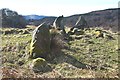
Neolithic and Bronze AgeSite Name: BaroileCountry: Scotland
NOTE: This site is 0.6 km away from the location you searched for.
County: Argyll Type: Chambered Cairn
Nearest Town: Lochgilphead Nearest Village: Kilmartin
Map Ref: NR8477195498 Landranger Map Number: 55
Latitude: 56.103618N Longitude: 5.462504W
Condition:
| 5 | Perfect |
| 4 | Almost Perfect |
| 3 | Reasonable but with some damage |
| 2 | Ruined but still recognisable as an ancient site |
| 1 | Pretty much destroyed, possibly visible as crop marks |
| 0 | No data. |
| -1 | Completely destroyed |
| 5 | Superb |
| 4 | Good |
| 3 | Ordinary |
| 2 | Not Good |
| 1 | Awful |
| 0 | No data. |
| 5 | Can be driven to, probably with disabled access |
| 4 | Short walk on a footpath |
| 3 | Requiring a bit more of a walk |
| 2 | A long walk |
| 1 | In the middle of nowhere, a nightmare to find |
| 0 | No data. |
| 5 | co-ordinates taken by GPS or official recorded co-ordinates |
| 4 | co-ordinates scaled from a detailed map |
| 3 | co-ordinates scaled from a bad map |
| 2 | co-ordinates of the nearest village |
| 1 | co-ordinates of the nearest town |
| 0 | no data |
Be the first person to rate this site - see the 'Contribute!' box in the right hand menu.
Internal Links:
External Links:
")
Canmore site no. 39467.
You may be viewing yesterday's version of this page. To see the most up to date information please register for a free account.
")
")
")
Do not use the above information on other web sites or publications without permission of the contributor.
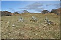
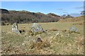
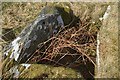
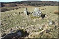
Nearby Images from Geograph Britain and Ireland:
©2015(licence)
©2015(licence)
©2015(licence)
©2015(licence)
©2015(licence)
The above images may not be of the site on this page, they are loaded from Geograph.
Please Submit an Image of this site or go out and take one for us!
Click here to see more info for this site
Nearby sites
Key: Red: member's photo, Blue: 3rd party photo, Yellow: other image, Green: no photo - please go there and take one, Grey: site destroyed
Download sites to:
KML (Google Earth)
GPX (GPS waypoints)
CSV (Garmin/Navman)
CSV (Excel)
To unlock full downloads you need to sign up as a Contributory Member. Otherwise downloads are limited to 50 sites.
Turn off the page maps and other distractions
Nearby sites listing. In the following links * = Image available
774m W 260° Rhudil Cairn (NR840954)
843m NW 323° Ballymeanoch Dun Stone Fort or Dun (NR843962)
1.2km ENE 72° Binnein Mor Stone Fort or Dun (NR859958)
1.5km WNW 302° Ballymeanoch Cairn* Cairn (NR83529637)
1.7km WNW 295° Ballymeanoch Henge* Henge (NR83319628)
1.7km WNW 301° Ballymeanoch Kerb Cairn* Cairn (NR8339596429)
1.7km WNW 300° Ballymeanoch Stone Row* Stone Row / Alignment (NR83379641)
1.7km WNW 299° Ballymeanoch Rock Art* Rock Art (NR833964)
1.8km SE 130° Torbhlaren Fallen Stone Standing Stone (Menhir) (NR86079428)
1.8km SE 125° Torbhlaran 1* Rock Art (NR8621394375)
1.8km NNW 336° Dun Mor, Dunchraigaig Stone Fort or Dun (NR841972)
1.9km ESE 119° Torbhlaran 2* Rock Art (NR8635294513)
1.9km ESE 119° Torbhlaran Stone* Standing Stone (Menhir) (NR8639794494)
2.0km NW 309° Dunchraigaig Cairn* Cairn (NR8330796811)
2.1km SSW 203° Dunadd Standing Stone* Standing Stone (Menhir) (NR8386993612)
2.2km NW 309° Baluachraig Rock Art* Rock Art (NR8312696966)
2.2km SSE 149° Kilmichael Glassary 2* Rock Art (NR8580993545)
2.2km SSW 207° Dunadd Fort* Hillfort (NR8367693573)
2.2km SSW 198° Dunadd Recumbent Stone* Standing Stone (Menhir) (NR83979343)
2.2km ESE 123° Dun Torbhlaran* Stone Fort or Dun (NR866942)
2.2km SSE 150° Kilmichael Glassary 1* Rock Art (NR8579793496)
2.3km SSE 147° Kilmichael Glassary Kirk* Ancient Cross (NR8589893521)
2.6km S 178° Dunamuck North* Standing Stones (NR8471392912)
2.7km WNW 282° Rowanfield Cist* Cist (NR8216096208)
2.7km W 275° Rowanfield Cottage* Standing Stone (Menhir) (NR82059585)
View more nearby sites and additional images


 We would like to know more about this location. Please feel free to add a brief description and any relevant information in your own language.
 Wir möchten mehr über diese Stätte erfahren. Bitte zögern Sie nicht, eine kurze Beschreibung und relevante Informationen in Deutsch hinzuzufügen.
 Nous aimerions en savoir encore un peu sur les lieux. S'il vous plaît n'hesitez pas à ajouter une courte description et tous les renseignements pertinents dans votre propre langue.
 Quisieramos informarnos un poco más de las lugares. No dude en añadir una breve descripción y otros datos relevantes en su propio idioma.