Featured: Lost Secrets - an adventure during Neolithic times

Lost Secrets - an adventure during Neolithic times

The Megalithic European

The Megalithic European

Who's Online

There are currently, 215 guests and 6 members online.

You are a guest. To join in, please register for free by clicking here

Sponsors

<< Our Photo Pages >> Trevelgue Head - Promontory Fort / Cliff Castle in England in Cornwall

Submitted by AngieLake on Thursday, 13 April 2017  Page Views: 31538

Iron Age and Later PrehistorySite Name: Trevelgue Head
Country: England County: Cornwall Type: Promontory Fort / Cliff Castle
Nearest Town: Newquay  Nearest Village: Porth
Map Ref: SW82506310  Landranger Map Number: 202
Latitude: 50.427374N  Longitude: 5.063636W
Condition:
5Perfect
4Almost Perfect
3Reasonable but with some damage
2Ruined but still recognisable as an ancient site
1Pretty much destroyed, possibly visible as crop marks
0No data.
-1Completely destroyed
3 Ambience:
5Superb
4Good
3Ordinary
2Not Good
1Awful
0No data.
5 Access:
5Can be driven to, probably with disabled access
4Short walk on a footpath
3Requiring a bit more of a walk
2A long walk
1In the middle of nowhere, a nightmare to find
0No data.
3 Accuracy:
5co-ordinates taken by GPS or official recorded co-ordinates
4co-ordinates scaled from a detailed map
3co-ordinates scaled from a bad map
2co-ordinates of the nearest village
1co-ordinates of the nearest town
0no data
4

Internal Links:
External Links:

I have visited· I would like to visit

optimistic20814 would like to visit

lucasn visited on 20th Oct 2018 - their rating: Cond: 3 Amb: 4 Access: 4

ajmp3003 visited on 1st Jan 2012 - their rating: Cond: 3 Amb: 4 Access: 5

AngieLake have visited here

Average ratings for this site from all visit loggers: Condition: 3 Ambience: 4 Access: 4.5

Trevelgue Head
Trevelgue Head submitted by Bladup : Trevelgue Head fort. (Vote or comment on this photo)
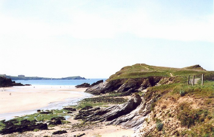
Trevelgue Head cliff castle is an outstanding Iron Age headland to the north of Newquay in Cornwall. Located at SW8250 6310, the ramparts are still impressive and the site is most dramatic when a heavy sea attacks the cliffs.

Nicholas Thomas, in his useful book, 'Guide to Prehistoric England', (Batsford/Book Club Associates, 1976) tells us more:
"This site must have been of special importance in prehistoric times because it protected a harbour probably used by those trading the local tin. Indeed evidence has been found here of bronze-smelting during the Bronze Age. The earthworks that are visible, however, belong to the Iron Age, with habitation lasting through the Roman period.
This site is divided today by a narrow cleft through which runs the sea. On the landward side 3 pairs of banks and ditches guard the approach, a fourth earthwork lying further to the E and cutting off nearly 200 yds of the Head. A second group of 3 banks and ditches (the cleft forming the island constituting the third ditch) defends the E end of this island. These rock-cut ditches and banks are all massive, the outermost being 12 ft deep and its bank 6-8 ft high. They enclose an area of nearly 6 acres.
Within, a series of huts has been excavated. They belong to the Iron Age, Roman and Dark Age periods. The foundations of some have been cut back into the natural rock and walls were of good quality drystone. Finds included Iron Age bronze horse harness and a small bronze foundry on the S side of the castle. Date of early occupation, c. 3rd century BC. Habitation continued beyond Roman period.
There are 2 round barrows close to the outermost rampart (about SW/825630). One has a diam. of 70 ft and a ht. of 12 ft.; the other is nearly 50 ft across and 10 ft high. Nothing is known of their contents. Date, c. 1,700-1,400 BC."
The Newquay Town Council sign at the beginning of the path through the site says:
"PORTH ISLAND
During the Iron-Age (6th (sic)-1st centuries BC) the headland, the settlement of an important local chieftain, was defended by six strong ramparts. Excavation has revealed the foundations of large round houses (no longer visible) and evidence for the smelting of iron ore, which is found on the headland. Two Bronze Age barrows or burial mounds (2000-1500 BC) can also be seen on the headland, and two more stand prominently on the cliff at Whipsiderry, a little to the east."
It is a beautiful site to visit, maybe to combine with a laze on sandy Porth beach, but be careful climbing the mound on the highest ground at the end of the headland, as there is a nasty drop over the cliffs on the seaward side! (I thought this was a barrow, but may be mistaken?) Angie Lake

Note: Beautiful new series of photos from Bladup
You may be viewing yesterday's version of this page. To see the most up to date information please register for a free account.


Trevelgue Head
Trevelgue Head submitted by AngieLake : Standing beside the eastern (land side) barrow of the two Bronze Age barrows on Trevelgue promontory fort, looking towards the two barrows on Trevelgue Down, on the next headland to the north. (Vote or comment on this photo)

Trevelgue Head
Trevelgue Head submitted by AngieLake : Looking back through the causeway opening in the first 'island' rampart at Trevelgue towards the eastern barrow, on the north side of the promontory, nearest the land. (Vote or comment on this photo)

Trevelgue Head
Trevelgue Head submitted by AngieLake : Porth Island or Trevelgue Iron Age Promontory fort with its defensive banks. (1 comment - Vote or comment on this photo)

Trevelgue Head
Trevelgue Head submitted by Bladup : The middle [with it's bridge], Western defences and Western barrow. (2 comments - Vote or comment on this photo)

Trevelgue Head
Trevelgue Head submitted by Bladup : Looking East over the interior of the fort from it's Western point. (1 comment)

Trevelgue Head
Trevelgue Head submitted by Bladup : The large bank and ditch of the biggest middle defences, Looking South.

Trevelgue Head
Trevelgue Head submitted by AngieLake : An old photo of Trevelgue Head cliff castle. Taken from booklet (old) acquired in second-hand shop of Old Photos of Newquay.

Trevelgue Head
Trevelgue Head submitted by AngieLake : Looking back from the 'island' of Trevelgue promontory fort, along its north edge, towards the eastern barrow, visible to the right of the hotels. It is a particularly nice place to visit in summer, with the pink 'Thrift' and the turquoise sea with its white breakers.

Trevelgue Head
Trevelgue Head submitted by AngieLake : Two shots of Trevelgue Head Promontory fort, showing (right) the causeway and first high ramparts of the 'island', with the highest western (seaward end) barrow (?), and, on the left, the strata of the cut-through rampart. (1 comment)

Trevelgue Head
Trevelgue Head submitted by Thorgrim : Trevelgue Head cliff castle is an outstanding Iron Age headland to the north of Newquay. Located at SW8250 6310, the ramparts are still impressive and the site is most dramatic when a heavy sea attacks the cliffs.

Trevelgue Head
Trevelgue Head submitted by Bladup : On the right is the Eastern Barrow and in the background on the left is the Western Barrow

Trevelgue Head
Trevelgue Head submitted by Bladup : The lovely North East view from the fort

Trevelgue Head
Trevelgue Head submitted by Bladup : The Western part of the fort from the Eastern Barrow

Trevelgue Head
Trevelgue Head submitted by Bladup : The Eastern Barrow

Trevelgue Head
Trevelgue Head submitted by Bladup : A onsite plan of Trevelgue Head Iron Age Fort

Trevelgue Head
Trevelgue Head submitted by Bladup : Looking at the Western side of the fort and the Western defences and Western Barrow

Trevelgue Head
Trevelgue Head submitted by Bladup : Trevelgue Head Iron Age Fort, The large middle defences

Trevelgue Head
Trevelgue Head submitted by Bladup : The Western Barrow

Trevelgue Head
Trevelgue Head submitted by Bladup : Trevelgue Head Iron Age Fort, Looking down over the main settlement site within the blue ellipse, Under the red lines are the two Bronze Age Barrows and under the yellow lines are the forts inner defences

Trevelgue Head
Trevelgue Head submitted by Bladup : Trevelgue Head Iron Age Fort from Porth Beach, You can see the two Bronze Age Barrows underneath the two red lines

Trevelgue Head
Trevelgue Head submitted by Bladup : Trevelgue Head from the South

Trevelgue Head
Trevelgue Head submitted by Bladup : Trevelgue Head from the Eastern Barrow

Trevelgue Head
Trevelgue Head submitted by Bladup : Looking at Trevelgue Head over Porth Beach, You can see the two barrows at either end

Trevelgue Head
Trevelgue Head submitted by Bladup : Trevelgue Head, The Northern side of the Western defences.

These are just the first 25 photos of Trevelgue Head. If you log in with a free user account you will be able to see our entire collection.

Do not use the above information on other web sites or publications without permission of the contributor.
Click here to see more info for this site

Nearby sites

Click here to view sites on an interactive OS map

Key: Red: member's photo, Blue: 3rd party photo, Yellow: other image, Green: no photo - please go there and take one, Grey: site destroyed

Download sites to:
KML (Google Earth)
GPX (GPS waypoints)
CSV (Garmin/Navman)
CSV (Excel)

To unlock full downloads you need to sign up as a Contributory Member. Otherwise downloads are limited to 50 sites.


Turn off the page maps and other distractions

Nearby sites listing. In the following links * = Image available
 1m E 90° Trevelgue* Barrow Cemetery (SW825631)
 1.0km NE 52° Zachry's Barrows* Barrow Cemetery (SW83356371)
 1.1km SSW 211° Barrowfields* Barrow Cemetery (SW819622)
 2.5km ESE 116° Rialton Manor* Holy Well or Sacred Spring (SW847619)
 3.1km SSW 207° Treringey Round* Ancient Village or Settlement (SW810604)
 3.4km ESE 102° St. Pedyr's Well* Holy Well or Sacred Spring (SW8579462245)
 3.8km NNE 24° Griffin's point fort* Promontory Fort / Cliff Castle (SW842665)
 4.3km SW 234° St Ambrusca's Well* Holy Well or Sacred Spring (SW789607)
 4.5km SW 231° Crantock* Holy Well or Sacred Spring (SW789604)
 4.6km WSW 249° East Pentire Barrow* Round Barrow(s) (SW781616)
 4.9km NNE 30° Mawgan Porth Settlement Ancient Village or Settlement (SW85126727)
 5.1km ENE 62° St James's Well, Ball* Holy Well or Sacred Spring (SW8709865269)
 5.2km ESE 119° Our Lady of Nance* Holy Well or Sacred Spring (SW870604)
 5.5km ENE 57° Mawgan Cross* Ancient Cross (SW87256594)
 5.5km ENE 57° St Mawgan's Holy Well* Holy Well or Sacred Spring (SW87276592)
 5.8km SW 228° Cubert Common Tumulus* Round Barrow(s) (SW78055943)
 6.2km NNE 19° Carnewas Longstone* Standing Stone (Menhir) (SW84756885)
 6.2km SE 142° Dairyland Farm World* Modern Stone Circle etc (SW861580)
 6.4km SSW 205° Cubert Round* Ancient Village or Settlement (SW796574)
 6.4km WSW 247° Kelsey Head* Promontory Fort / Cliff Castle (SW765608)
 6.6km SW 214° Cubert.* Early Christian Sculptured Stone (SW786578)
 6.6km WSW 240° Holywell Bay* Holy Well or Sacred Spring (SW76636002)
 6.6km SW 228° Trevornick Farm* Holy Well or Sacred Spring (SW7733958890)
 6.8km NE 41° St Eval Airport Stone* Standing Stone (Menhir) (SW87146803)
 7.0km NNE 18° Redcliff Castle* Promontory Fort / Cliff Castle (SW84926965)
View more nearby sites and additional images

<< Caer Kief

Griffin's point fort >>

Please add your thoughts on this site

Cornwall in Prehistory

Cornwall in Prehistory

Sponsors

Auto-Translation (Google)

Translate from English into:

"Trevelgue Head" | Login/Create an Account | 6 News and Comments
  
Go back to top of page    Comments are owned by the poster. We aren't responsible for their content.
Porth Island (Trevelgue Head) by lucasn on Monday, 10 December 2018
(User Info | Send a Message)
[ Reply to This ]

Could visitors who flock to magnificent ancient site be causing damage? by bat400 on Monday, 24 November 2014
(User Info | Send a Message)
A majestic Iron Age fortress said to be one of the finest in the Westcountry is being scrutinised to see if the thousands of visitors who flock there are damaging the site.

A survey has been ordered at Trevelgue Head Cliff Castle, Porth Island, Newquay to assess erosion which may have been caused from people and the winter storms.

Cornwall Council Senior Archaeologist Ann Reynolds said it was important to check on whether there were any problems.
“It is one of the most heavily defended headlands in Cornwall but as a result of natural erosion and visitor pressure it is probably also one of the most heavily denuded,” she said.

“Last winter’s storms have also caused significant areas of erosion and minor landslips, exposing fragile archaeological layers and features.”

Sheila Harper of the Newquay Old Cornwall Society Archaeology Group said it was a chance to look into an important chapter of history and urged anyone who wanted to volunteer to get in touch.
“We are really excited at the opportunity to take part in this project, which will help look after an important part of Newquay’s past,” she said.

Trevelgue Head Cliff Castle is one of Cornwall’s finest ancient monuments and contains eight massive earth and stone ramparts, two large early Bronze Age barrows and the foundations of several large roundhouses which are thought to be unique. The ramparts defended an east-west headland 700metres long and on its south side, the excellent natural harbour of St Columb Porth.

The site is designated by English Heritage as a Scheduled Monument.

The survey will provide a comprehensive record of the current areas of erosion, which can be monitored in the future and will enable recommendations to be made on how to deal with the eroded areas.

It is being funded by Natural England’s Higher Level Stewardship Scheme, following recommendations for this work by Cornwall Council’s Countryside Archaeologist and the Heritage at Risk Project Officer for English Heritage.

As part of the work, local members of Newquay Old Cornwall Society will be trained on how to carry out future monitoring of the site, building on their current and much valued on site recording and scrub clearance work. A second stage of work, likely to take place next spring, will see priority consolidation repairs and recording taking place.

Trevelgue Headland is a public open space owned and maintained by Cornwall Council.

Thanks to coldrum for the link. Read more: http://www.westernmorningnews.co.uk.
[ Reply to This ]

Re: Trevelgue Head by mishkin on Friday, 24 February 2006
(User Info | Send a Message)
Nicholas Thomas, in his useful book, 'Guide to Prehistoric England', (Batsford/Book Club Associates, 1976....

Snap, also own that book but mine's 1960, it is a most useful book for giving size and diameters of everything, especially for Wiltshire..
[ Reply to This ]

Re: Trevelgue Head by Thorgrim on Friday, 24 February 2006
(User Info | Send a Message)
Excellent and informative photo essay, Angie. Well done!
[ Reply to This ]
    Re: Trevelgue Head by AngieLake on Friday, 24 February 2006
    (User Info | Send a Message)
    Thanks Thorgrim! I thought a few sunshiny summer pics of Cornwall might cheer us all up during these cold grey winter days!
    [ Reply to This ]

Your Name: Anonymous [ Register Now ]
Subject:


Add your comment or contribution to this page. Spam or offensive posts are deleted immediately, don't even bother

<<< What is five plus one as a number? (Please type the answer to this question in the little box on the left)
You can also embed videos and other things. For Youtube please copy and paste the 'embed code'.
For Google Street View please include Street View in the text.
Create a web link like this: <a href="https://www.megalithic.co.uk">This is a link</a>  

Allowed HTML is:
<p> <b> <i> <a> <img> <em> <br> <strong> <blockquote> <tt> <li> <ol> <ul> <object> <param> <embed> <iframe>

We would like to know more about this location. Please feel free to add a brief description and any relevant information in your own language.
Wir möchten mehr über diese Stätte erfahren. Bitte zögern Sie nicht, eine kurze Beschreibung und relevante Informationen in Deutsch hinzuzufügen.
Nous aimerions en savoir encore un peu sur les lieux. S'il vous plaît n'hesitez pas à ajouter une courte description et tous les renseignements pertinents dans votre propre langue.
Quisieramos informarnos un poco más de las lugares. No dude en añadir una breve descripción y otros datos relevantes en su propio idioma.