

<< Our Photo Pages >> Carrick Luz - Promontory Fort / Cliff Castle in England in Cornwall
Submitted by SolarMegalith on Saturday, 04 June 2011 Page Views: 6795
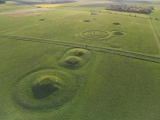
Iron Age and Later PrehistorySite Name: Carrick Luz Alternative Name: LankiddenCountry: England County: Cornwall Type: Promontory Fort / Cliff Castle
Nearest Town: Helston Nearest Village: Kuggar
Map Ref: SW755165
Latitude: 50.006278N Longitude: 5.134468W
Condition:
| 5 | Perfect |
| 4 | Almost Perfect |
| 3 | Reasonable but with some damage |
| 2 | Ruined but still recognisable as an ancient site |
| 1 | Pretty much destroyed, possibly visible as crop marks |
| 0 | No data. |
| -1 | Completely destroyed |
| 5 | Superb |
| 4 | Good |
| 3 | Ordinary |
| 2 | Not Good |
| 1 | Awful |
| 0 | No data. |
| 5 | Can be driven to, probably with disabled access |
| 4 | Short walk on a footpath |
| 3 | Requiring a bit more of a walk |
| 2 | A long walk |
| 1 | In the middle of nowhere, a nightmare to find |
| 0 | No data. |
| 5 | co-ordinates taken by GPS or official recorded co-ordinates |
| 4 | co-ordinates scaled from a detailed map |
| 3 | co-ordinates scaled from a bad map |
| 2 | co-ordinates of the nearest village |
| 1 | co-ordinates of the nearest town |
| 0 | no data |
Internal Links:
External Links:
")
Read More at PastScape.
You may be viewing yesterday's version of this page. To see the most up to date information please register for a free account.
")
")
")
")
")
Do not use the above information on other web sites or publications without permission of the contributor.
Click here to see more info for this site
Nearby sites
Key: Red: member's photo, Blue: 3rd party photo, Yellow: other image, Green: no photo - please go there and take one, Grey: site destroyed
Download sites to:
KML (Google Earth)
GPX (GPS waypoints)
CSV (Garmin/Navman)
CSV (Excel)
To unlock full downloads you need to sign up as a Contributory Member. Otherwise downloads are limited to 50 sites.
Turn off the page maps and other distractions
Nearby sites listing. In the following links * = Image available
669m WNW 294° Poldowrian Round House* Ancient Village or Settlement (SW749168)
1.9km E 97° Dynas Cove* Promontory Fort / Cliff Castle (SW774162)
2.6km WNW 299° Goonhilly Downs Barrows* Barrow Cemetery (SW73261786)
3.1km NNE 25° Tide Rock* Rock Outcrop (SW76921923)
3.1km ENE 71° Chynhalls Point Fort* Promontory Fort / Cliff Castle (SW785174)
3.2km WSW 246° Carleon Stone Circle* Stone Circle (SW72551535)
3.3km NNE 33° Crousa Downs Settlement* Ancient Village or Settlement (SW77401916)
3.3km N 9° Three Brothers of Grugith* Burial Chamber or Dolmen (SW76161978)
3.6km W 260° Treal Barrows* Barrow Cemetery (SW71921605)
3.6km NNE 29° Little Kistles Kerb Cairn* Cairn (SW77411959)
3.8km NNE 26° St Keverne Beacon Tumulus* Chambered Cairn (SW77361987)
4.0km NW 314° Croft Pascoe Forrest Barrows* Barrow Cemetery (SW7273819434)
4.0km NNE 27° Crousa Common* Standing Stones (SW775200)
4.4km WSW 243° St Ruan's Well (Cadgwith)* Holy Well or Sacred Spring (SW7151714671)
4.9km NNW 337° Traboe Barrow Cemetery* Barrow Cemetery (SW7378321099)
5.0km NNE 25° Tremenhere Menhir* Standing Stone (Menhir) (SW778210)
5.1km WNW 303° Goonhilly Downs Kerb Cairn* Barrow Cemetery (SW71331951)
5.5km W 259° Moyle's Burrow* Round Barrow(s) (SW70051569)
5.5km NW 325° Dry Tree Menhir* Standing Stone (Menhir) (SW72562116)
5.5km NW 315° Bochym Tumuli* Barrow Cemetery (SW71762056)
5.5km WNW 301° Carn Maer Tumuli* Barrow Cemetery (SW70861954)
5.6km NE 55° Lowland Point* Ancient Village or Settlement (SW80251952)
5.8km SW 226° Landewednack Cross* Ancient Cross (SW71111268)
5.8km NNW 327° Goonhilly tumuli* Round Barrow(s) (SW725215)
5.8km W 266° St Helena Barrow Round Barrow(s) (SW69661632)
View more nearby sites and additional images


 We would like to know more about this location. Please feel free to add a brief description and any relevant information in your own language.
 Wir möchten mehr über diese Stätte erfahren. Bitte zögern Sie nicht, eine kurze Beschreibung und relevante Informationen in Deutsch hinzuzufügen.
 Nous aimerions en savoir encore un peu sur les lieux. S'il vous plaît n'hesitez pas à ajouter une courte description et tous les renseignements pertinents dans votre propre langue.
 Quisieramos informarnos un poco más de las lugares. No dude en añadir una breve descripción y otros datos relevantes en su propio idioma.