

<< Other Photo Pages >> Blasthill - Chambered Cairn in Scotland in Argyll
Submitted by Andy B on Friday, 13 February 2015 Page Views: 7076
Neolithic and Bronze AgeSite Name: BlasthillCountry: Scotland
NOTE: This site is 0.2 km away from the location you searched for.
County: Argyll Type: Chambered Cairn
Nearest Town: Campbelltown
Map Ref: NR7201009289 Landranger Map Number: 68
Latitude: 55.324660N Longitude: 5.59544W
Condition:
| 5 | Perfect |
| 4 | Almost Perfect |
| 3 | Reasonable but with some damage |
| 2 | Ruined but still recognisable as an ancient site |
| 1 | Pretty much destroyed, possibly visible as crop marks |
| 0 | No data. |
| -1 | Completely destroyed |
| 5 | Superb |
| 4 | Good |
| 3 | Ordinary |
| 2 | Not Good |
| 1 | Awful |
| 0 | No data. |
| 5 | Can be driven to, probably with disabled access |
| 4 | Short walk on a footpath |
| 3 | Requiring a bit more of a walk |
| 2 | A long walk |
| 1 | In the middle of nowhere, a nightmare to find |
| 0 | No data. |
| 5 | co-ordinates taken by GPS or official recorded co-ordinates |
| 4 | co-ordinates scaled from a detailed map |
| 3 | co-ordinates scaled from a bad map |
| 2 | co-ordinates of the nearest village |
| 1 | co-ordinates of the nearest town |
| 0 | no data |
Internal Links:
External Links:
")
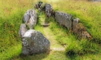
Excavations in 2009 have shed much light on the development and use of the site. Later in the early Neolithic alliances appear to have switched, and there was an increased focus on Irish connections. This was manifested in the unique remodelling of the forecourt at Blasthill to resemble a court cairn. The chambered tomb saw a renewed focus of activity in the Early Bronze Age. Full details are in the excavation report linked below.
Note: The life and times of a chambered tomb: the newly published survey and excavation results from Blasthill
You may be viewing yesterday's version of this page. To see the most up to date information please register for a free account.
Do not use the above information on other web sites or publications without permission of the contributor.
Nearby Images from Geograph Britain and Ireland:
©2021(licence)
©2012(licence)
©2010(licence)
©2018(licence)
©2013(licence)
The above images may not be of the site on this page, they are loaded from Geograph.
Please Submit an Image of this site or go out and take one for us!
Click here to see more info for this site
Nearby sites
Key: Red: member's photo, Blue: 3rd party photo, Yellow: other image, Green: no photo - please go there and take one, Grey: site destroyed
Download sites to:
KML (Google Earth)
GPX (GPS waypoints)
CSV (Garmin/Navman)
CSV (Excel)
To unlock full downloads you need to sign up as a Contributory Member. Otherwise downloads are limited to 50 sites.
Turn off the page maps and other distractions
Nearby sites listing. In the following links * = Image available
1.6km E 88° Macharioch Chambered Cairn (NR73640927)
2.6km SW 235° Brunerican Standing Stone Standing Stone (Menhir) (NR6976207877)
3.6km NNW 328° Knockstapple* Standing Stone (Menhir) (NR70261241)
5.0km WSW 248° St Columba's Well (Southend)* Holy Well or Sacred Spring (NR673077)
5.0km NE 52° Dun Bastard (Campbelltown) Hillfort (NR76121220)
8.2km NW 316° Lochorodale Stone Standing Stone (Menhir) (NR66571546)
8.3km NW 313° Lochorodale Chambered Cairn* Chambered Cairn (NR66231522)
9.3km NW 316° Lochorodale Cairn (NR658163)
9.5km NNE 12° Glenramskill Fort* Hillfort (NR7455118507)
10.7km NNW 346° Stewarton Recumbent Stone Standing Stone (Menhir) (NR6995719821)
10.7km NNW 346° Culinlongart Recumbent Standing Stone (Menhir) (NR69951982)
11.0km N 358° Campbeltown Museum* Museum (NR7211620336)
11.9km N 359° Campbeltown* Standing Stone (Menhir) (NR7239321234)
13.6km NW 323° Macrihanish Stone Row / Alignment (NR644206)
14.5km NNW 346° Craigs East (Kintyre)* Standing Stone (Menhir) (NR6932623544)
14.6km NNW 345° Craigs (Kintyre)* Standing Stone (Menhir) (NR6903123633)
15.0km N 6° Greenland Chambered Cairn (NR743241)
15.0km NNW 347° Craigs NE (Kintyre) Recumbent Standing Stone (Menhir) (NR6949924121)
16.4km NNW 335° Clochkeil* Stone Row / Alignment (NR6577824456)
16.6km NNW 348° High Park Stone* Standing Stone (Menhir) (NR69442573)
16.6km NNE 11° Glenlussa Lodge* Standing Stone (Menhir) (NR76152543)
16.9km NNE 12° Peninver Bridge Standing Stone* Standing Stone (Menhir) (NR76352570)
17.0km N 8° Kilkeddan Farm cist burial Cist (NR75252600)
17.2km NNE 13° The Priest's Grave (Ardnacross)* Cist (NR76662592)
17.5km NNE 13° Ardnacross 2 Chambered Cairn (NR768261)
View more nearby sites and additional images


 We would like to know more about this location. Please feel free to add a brief description and any relevant information in your own language.
 Wir möchten mehr über diese Stätte erfahren. Bitte zögern Sie nicht, eine kurze Beschreibung und relevante Informationen in Deutsch hinzuzufügen.
 Nous aimerions en savoir encore un peu sur les lieux. S'il vous plaît n'hesitez pas à ajouter une courte description et tous les renseignements pertinents dans votre propre langue.
 Quisieramos informarnos un poco más de las lugares. No dude en añadir una breve descripción y otros datos relevantes en su propio idioma.