


<< Our Photo Pages >> Dun Ela - Stone Fort or Dun in Scotland in Isle of Skye
Submitted by Andy B on Tuesday, 19 October 2010 Page Views: 3140
Multi-periodSite Name: Dun ElaCountry: Scotland County: Isle of Skye Type: Stone Fort or Dun
Map Ref: NG64640569
Latitude: 57.081855N Longitude: 5.88564W
Condition:
| 5 | Perfect |
| 4 | Almost Perfect |
| 3 | Reasonable but with some damage |
| 2 | Ruined but still recognisable as an ancient site |
| 1 | Pretty much destroyed, possibly visible as crop marks |
| 0 | No data. |
| -1 | Completely destroyed |
| 5 | Superb |
| 4 | Good |
| 3 | Ordinary |
| 2 | Not Good |
| 1 | Awful |
| 0 | No data. |
| 5 | Can be driven to, probably with disabled access |
| 4 | Short walk on a footpath |
| 3 | Requiring a bit more of a walk |
| 2 | A long walk |
| 1 | In the middle of nowhere, a nightmare to find |
| 0 | No data. |
| 5 | co-ordinates taken by GPS or official recorded co-ordinates |
| 4 | co-ordinates scaled from a detailed map |
| 3 | co-ordinates scaled from a bad map |
| 2 | co-ordinates of the nearest village |
| 1 | co-ordinates of the nearest town |
| 0 | no data |
Be the first person to rate this site - see the 'Contribute!' box in the right hand menu.
Internal Links:
External Links:
")
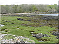
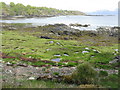
On the shore about 400 yards SSW of Ostaig House is a flat-topped rock tapering away towards the land in a gradually narrowing ridge and rising abruptly some 25ft above the strand. The summit it occupied by the remains of a Dun Ila, a small fort of quadrilateral shape, measuring internally some 46ft NW-SE and 31ft across the widest part, which is next the sea. The remains of its wall, built on the edge of the rock, are traceable all around except on the NE flank. The best preserved parts are towards the land to the NW, where it shows a breadth of 9ft and a height of 4ft 6ins above the interior, and at the W corner, where it is 3ft 6ins high.
Source: Canmore
You may be viewing yesterday's version of this page. To see the most up to date information please register for a free account.
")
")
Do not use the above information on other web sites or publications without permission of the contributor.
Nearby Images from Geograph Britain and Ireland:
©2013(licence)
©2013(licence)
©2013(licence)
©2013(licence)
©2006(licence)
The above images may not be of the site on this page, they are loaded from Geograph.
Please Submit an Image of this site or go out and take one for us!
Click here to see more info for this site
Nearby sites
Key: Red: member's photo, Blue: 3rd party photo, Yellow: other image, Green: no photo - please go there and take one, Grey: site destroyed
Download sites to:
KML (Google Earth)
GPX (GPS waypoints)
CSV (Garmin/Navman)
CSV (Excel)
To unlock full downloads you need to sign up as a Contributory Member. Otherwise downloads are limited to 50 sites.
Turn off the page maps and other distractions
Nearby sites listing. In the following links * = Image available
1.9km NE 44° Dun Faich Stone Fort or Dun (NG66020697)
2.0km SSW 195° Cists near Armadale Pier Burial Chamber or Dolmen (NG640038)
2.0km SSW 205° Armadale Bay Cairn Cairn (NG63680390)
3.0km SSW 204° Dun Acardinon* Stone Fort or Dun (NG63250305)
4.5km NE 51° Dun Choinnich* Broch or Nuraghe (NG68290834)
5.1km SSW 211° Dun Chlo (Tormore)* Stone Fort or Dun (NG618015)
5.2km NE 35° Dun Knock (Toravaig)* Stone Fort or Dun (NG679098)
5.8km ESE 107° Dun Ban (Doune)* Stone Fort or Dun (NG70110362)
6.2km SW 217° Dun A'Chleirich* Stone Fort or Dun (NG60590091)
6.6km NNW 342° Meal-da-Bheinn* Stone Circle (NG629121)
7.0km SW 218° Dun Ban (Sleat)* Stone Fort or Dun (NG60030042)
7.2km NW 307° Cnoc an Temple* Burial Chamber or Dolmen (NG591104)
7.4km NE 45° Dun Ban (Camascross) Stone Fort or Dun (NG70121065)
7.9km W 260° Dun Geilbt Stone Fort or Dun (NG56750480)
8.0km NNW 336° Teampuill Chaon* Early Christian Sculptured Stone (NG61831321)
8.0km NNW 327° Inver Aulavaig 2* Cairn (NG6059112629)
8.1km NW 325° Inver Aulavaig 1* Cairn (NG60441259)
8.2km NNW 336° Tobar Chaon* Holy Well or Sacred Spring (NG61711340)
10.9km NNW 340° Dun Boreraig Fort* Hillfort (NG615162)
11.0km NNW 343° Dun Boreraig Stone* Standing Stone (Menhir) (NG61951638)
12.1km N 359° Heaste Stone Standing Stone (Menhir) (NG6505117847)
12.8km NNW 334° Dun Kearstack* Hillfort (NG596175)
12.9km WNW 298° Dun Grugaig (Skye)* Stone Fort or Dun (NG53541229)
13.4km NW 307° Dun Liath (Elgol)* Broch or Nuraghe (NG54331427)
13.6km NW 305° Allt Na Cille Souterrain (Fogou, Earth House) (NG539141)
View more nearby sites and additional images


 We would like to know more about this location. Please feel free to add a brief description and any relevant information in your own language.
 Wir möchten mehr über diese Stätte erfahren. Bitte zögern Sie nicht, eine kurze Beschreibung und relevante Informationen in Deutsch hinzuzufügen.
 Nous aimerions en savoir encore un peu sur les lieux. S'il vous plaît n'hesitez pas à ajouter une courte description et tous les renseignements pertinents dans votre propre langue.
 Quisieramos informarnos un poco más de las lugares. No dude en añadir una breve descripción y otros datos relevantes en su propio idioma.