


<< Our Photo Pages >> Godrevy Headland Barrow - Round Barrow(s) in England in Cornwall
Submitted by Bladup on Monday, 14 January 2013 Page Views: 5103
Neolithic and Bronze AgeSite Name: Godrevy Headland BarrowCountry: England County: Cornwall Type: Round Barrow(s)
Nearest Town: Hayle Nearest Village: Gwithian
Map Ref: SW58124330
Latitude: 50.240084N Longitude: 5.393581W
Condition:
| 5 | Perfect |
| 4 | Almost Perfect |
| 3 | Reasonable but with some damage |
| 2 | Ruined but still recognisable as an ancient site |
| 1 | Pretty much destroyed, possibly visible as crop marks |
| 0 | No data. |
| -1 | Completely destroyed |
| 5 | Superb |
| 4 | Good |
| 3 | Ordinary |
| 2 | Not Good |
| 1 | Awful |
| 0 | No data. |
| 5 | Can be driven to, probably with disabled access |
| 4 | Short walk on a footpath |
| 3 | Requiring a bit more of a walk |
| 2 | A long walk |
| 1 | In the middle of nowhere, a nightmare to find |
| 0 | No data. |
| 5 | co-ordinates taken by GPS or official recorded co-ordinates |
| 4 | co-ordinates scaled from a detailed map |
| 3 | co-ordinates scaled from a bad map |
| 2 | co-ordinates of the nearest village |
| 1 | co-ordinates of the nearest town |
| 0 | no data |
Internal Links:
External Links:
I have visited· I would like to visit
LiveAndrew visited on 10th Mar 2022 - their rating: Cond: 3 Amb: 4 Access: 4
Catrinm visited on 21st May 2021 - their rating: Cond: 2 Amb: 3 Access: 4
lucasn visited on 22nd Jul 2020 - their rating: Cond: 3 Amb: 5 Access: 4
Bladup have visited here
Average ratings for this site from all visit loggers: Condition: 2.67 Ambience: 4 Access: 4
")
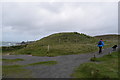
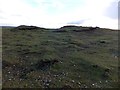
Pastscape says "The remains of a round barrow on Godrevy headland, A small Mesolithic flint chipping floor was found beneath the barrow. The finds which included a perforated mace-head, cores, microliths and scrapers, are in the collection of Prof. C.Thomas. An A3 type penannular bronze brooch of the 1st to 3rd centuries AD was found during the trial excavations in 1950".
You may be viewing yesterday's version of this page. To see the most up to date information please register for a free account.
")
")
")
Do not use the above information on other web sites or publications without permission of the contributor.
Nearby Images from Geograph Britain and Ireland:
©2017(licence)
©2019(licence)
©2011(licence)

©2013(licence)
©2014(licence)
The above images may not be of the site on this page, they are loaded from Geograph.
Please Submit an Image of this site or go out and take one for us!
Click here to see more info for this site
Nearby sites
Key: Red: member's photo, Blue: 3rd party photo, Yellow: other image, Green: no photo - please go there and take one, Grey: site destroyed
Download sites to:
KML (Google Earth)
GPX (GPS waypoints)
CSV (Garmin/Navman)
CSV (Excel)
To unlock full downloads you need to sign up as a Contributory Member. Otherwise downloads are limited to 50 sites.
Turn off the page maps and other distractions
Nearby sites listing. In the following links * = Image available
1.4km SE 136° Godrevy Towans Settlement Ancient Village or Settlement (SW59034228)
1.4km SE 138° Godrevy Towans Barrow Round Barrow(s) (SW59004225)
1.4km SE 135° Gwithian prehistoric settlement* Ancient Village or Settlement (SW59044228)
1.5km SE 126° St Gwithian's Holy Well* Holy Well or Sacred Spring (SW59314236)
2.2km SSE 165° Gwithian's Churchyard Cornish Cross* Ancient Cross (SW586412)
2.2km SSE 160° Gwithian Round* Ancient Village or Settlement (SW58784121)
2.4km ESE 119° Gwealavellan* Ancient Cross (SW602420)
2.5km E 94° Hudder Down Tumulus* Round Barrow(s) (SW60654302)
2.7km SE 146° Pennance Round* Ancient Village or Settlement (SW59554096)
2.9km ESE 118° Carlenno Round* Ancient Village or Settlement (SW60624180)
3.2km SSE 166° Trevarnon Round* Ancient Village or Settlement (SW58734016)
3.4km S 173° Carwin Round* Ancient Village or Settlement (SW58413992)
3.7km ESE 123° Trevorian Round* Ancient Village or Settlement (SW61154110)
4.4km SSE 150° Connor Downs* Barrow Cemetery (SW60183938)
4.8km SSW 193° Phillack Towans Stone* Standing Stone (Menhir) (SW56873871)
5.0km SSW 196° Mexico Cross* Ancient Cross (SW56523851)
5.1km SSW 195° Inscribed stone Phillack* Early Christian Sculptured Stone (SW56563842)
5.1km SSE 163° Coldharbour barrow* Round Barrow(s) (SW59423833)
5.2km SSW 195° Phillack Cross* Ancient Cross (SW56523840)
5.2km SSW 196° St Phillack's Well* Holy Well or Sacred Spring (SW565384)
5.4km E 80° Crane Castle* Promontory Fort / Cliff Castle (SW635440)
5.6km SE 142° Gwinear Holy Well* Holy Well or Sacred Spring (SW614387)
5.8km E 92° Oak Wood Settlement* Ancient Village or Settlement (SW63874279)
5.9km E 84° North Cliff Settlement* Ancient Village or Settlement (SW63994368)
6.1km SSE 164° Gwinear Cross* Ancient Cross (SW59503739)
View more nearby sites and additional images


 We would like to know more about this location. Please feel free to add a brief description and any relevant information in your own language.
 Wir möchten mehr über diese Stätte erfahren. Bitte zögern Sie nicht, eine kurze Beschreibung und relevante Informationen in Deutsch hinzuzufügen.
 Nous aimerions en savoir encore un peu sur les lieux. S'il vous plaît n'hesitez pas à ajouter une courte description et tous les renseignements pertinents dans votre propre langue.
 Quisieramos informarnos un poco más de las lugares. No dude en añadir una breve descripción y otros datos relevantes en su propio idioma.