


<< Our Photo Pages >> Cadha Riach - Chambered Tomb in Scotland in Isle of Skye
Submitted by uisdean on Wednesday, 02 May 2007 Page Views: 8990
Neolithic and Bronze AgeSite Name: Cadha Riach Alternative Name: GarafadCountry: Scotland County: Isle of Skye Type: Chambered Tomb
Nearest Town: Portree Nearest Village: Staffin
Map Ref: NG49556757
Latitude: 57.628279N Longitude: 6.196841W
Condition:
| 5 | Perfect |
| 4 | Almost Perfect |
| 3 | Reasonable but with some damage |
| 2 | Ruined but still recognisable as an ancient site |
| 1 | Pretty much destroyed, possibly visible as crop marks |
| 0 | No data. |
| -1 | Completely destroyed |
| 5 | Superb |
| 4 | Good |
| 3 | Ordinary |
| 2 | Not Good |
| 1 | Awful |
| 0 | No data. |
| 5 | Can be driven to, probably with disabled access |
| 4 | Short walk on a footpath |
| 3 | Requiring a bit more of a walk |
| 2 | A long walk |
| 1 | In the middle of nowhere, a nightmare to find |
| 0 | No data. |
| 5 | co-ordinates taken by GPS or official recorded co-ordinates |
| 4 | co-ordinates scaled from a detailed map |
| 3 | co-ordinates scaled from a bad map |
| 2 | co-ordinates of the nearest village |
| 1 | co-ordinates of the nearest town |
| 0 | no data |
Internal Links:
External Links:
")
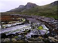
Remains of a chambered cairn at Garafad. The remains consist of 6 stones on a low grassy mound forming part of the chamber, and three likely kerbstones in the south and two in the west suggesting an original diameter of 15 feet.
The Cairn is approached by a footpath which now starts behind the car park at the new St Columba Leadership Centre in Staffin. The OS 1:50,000 map marks it wrongly on the right hand side of the footpath as you approach the sea; it is in fact on the left.
You may be viewing yesterday's version of this page. To see the most up to date information please register for a free account.
")
Do not use the above information on other web sites or publications without permission of the contributor.
Nearby Images from Geograph Britain and Ireland:
©2012(licence)

©2023(licence)
©2008(licence)
©2017(licence)
©2011(licence)
The above images may not be of the site on this page, they are loaded from Geograph.
Please Submit an Image of this site or go out and take one for us!
Click here to see more info for this site
Nearby sites
Key: Red: member's photo, Blue: 3rd party photo, Yellow: other image, Green: no photo - please go there and take one, Grey: site destroyed
Download sites to:
KML (Google Earth)
GPX (GPS waypoints)
CSV (Garmin/Navman)
CSV (Excel)
To unlock full downloads you need to sign up as a Contributory Member. Otherwise downloads are limited to 50 sites.
Turn off the page maps and other distractions
Nearby sites listing. In the following links * = Image available
1.1km WNW 303° Carn Ban (Skye)* Cairn (NG487682)
1.1km SSW 213° Dun Smail* Stone Fort or Dun (NG489667)
1.1km NNW 333° An Corran* Ancient Mine, Quarry or other Industry (NG49106860)
2.5km SSE 155° Dun Grianan* Broch or Nuraghe (NG505652)
3.3km SSE 154° Raisaburgh Cairn* Cairn (NG508645)
3.4km NW 310° Loch Sheanta* Holy Well or Sacred Spring (NG471699)
3.4km SSE 163° Dun Raisaburgh* Broch or Nuraghe (NG50326427)
3.5km W 278° Dun Beag (Brogaig)* Hillfort (NG46076827)
3.6km WNW 298° Dun Vallerain* Hillfort (NG46476943)
3.7km SSE 147° Dun Dearg* Stone Fort or Dun (NG51376430)
4.9km SSE 161° Dun Connavern* Stone Fort or Dun (NG50856284)
5.3km NW 321° Tobar Kiltavie, Flodigarry* Holy Well or Sacred Spring (NG46457185)
5.4km NW 321° Dun Flodigarry* Broch or Nuraghe (NG46397196)
5.6km W 261° Cleat Hillfort Artificial Mound (NG440670)
5.6km NW 321° Druim Nan Slochd Dun* Hillfort (NG463721)
7.6km S 173° Dun Taivson Stone Fort or Dun (NG56)
8.9km SSE 161° Upper Tote* Cairn (NG51865898)
10.1km SSE 160° Rigg Promontory Fort* Promontory Fort / Cliff Castle (NG52375790)
10.7km W 277° Kilvaxter souterrain* Souterrain (Fogou, Earth House) (NG3900569619)
10.9km WNW 289° Osmigarry* Standing Stone (Menhir) (NG3943571814)
11.2km WSW 241° Uig.* Standing Stone (Menhir) (NG394628)
12.4km W 272° Carn Liath (Skye)* Chambered Cairn (NG372688)
12.5km WSW 253° Dun Skudiburgh* Stone Fort or Dun (NG373647)
12.9km WNW 285° Dun Bornaskitaig* Broch or Nuraghe (NG37267161)
13.4km SW 230° Snizort Stone Setting* Stone Circle (NG38755962)
View more nearby sites and additional images


 We would like to know more about this location. Please feel free to add a brief description and any relevant information in your own language.
 Wir möchten mehr über diese Stätte erfahren. Bitte zögern Sie nicht, eine kurze Beschreibung und relevante Informationen in Deutsch hinzuzufügen.
 Nous aimerions en savoir encore un peu sur les lieux. S'il vous plaît n'hesitez pas à ajouter une courte description et tous les renseignements pertinents dans votre propre langue.
 Quisieramos informarnos un poco más de las lugares. No dude en añadir una breve descripción y otros datos relevantes en su propio idioma.