 with our Megalithic Portal iPhone app")


<< Our Photo Pages >> Kildalton Cross - Ancient Cross in Scotland in Isle of Islay
Submitted by swatson on Thursday, 14 October 2004 Page Views: 10996
Early Medieval (Dark Age)Site Name: Kildalton CrossCountry: Scotland
NOTE: This site is 1.9 km away from the location you searched for.
County: Isle of Islay Type: Ancient Cross
Map Ref: NR4580250830
Latitude: 55.684161N Longitude: 6.045549W
Condition:
| 5 | Perfect |
| 4 | Almost Perfect |
| 3 | Reasonable but with some damage |
| 2 | Ruined but still recognisable as an ancient site |
| 1 | Pretty much destroyed, possibly visible as crop marks |
| 0 | No data. |
| -1 | Completely destroyed |
| 5 | Superb |
| 4 | Good |
| 3 | Ordinary |
| 2 | Not Good |
| 1 | Awful |
| 0 | No data. |
| 5 | Can be driven to, probably with disabled access |
| 4 | Short walk on a footpath |
| 3 | Requiring a bit more of a walk |
| 2 | A long walk |
| 1 | In the middle of nowhere, a nightmare to find |
| 0 | No data. |
| 5 | co-ordinates taken by GPS or official recorded co-ordinates |
| 4 | co-ordinates scaled from a detailed map |
| 3 | co-ordinates scaled from a bad map |
| 2 | co-ordinates of the nearest village |
| 1 | co-ordinates of the nearest town |
| 0 | no data |
Internal Links:
External Links:
I have visited· I would like to visit
coin would like to visit
kelpie nicoladidsbury have visited here
")
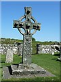
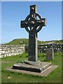
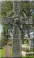
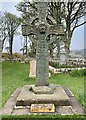
Carved from a single piece of epidiorite in the 6th century, this peerless cross still stands proudly next to the ruins of a church which it pre-dates by several centuries.
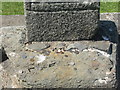
Kildalton cross and chapel located off the A846. The Celtic cross, which is preserved in the churchyard, is the finest surviving high cross in Scotland. Standing 2.7 metres (9ft) high, it was cut from a single slab of epidiorite in the 6th century. The chapel itself is a ruin, but nearby there are a number of early grave-slabs, among them a figure of a medieval knight.
Canmore site no. 251294.
You may be viewing yesterday's version of this page. To see the most up to date information please register for a free account.
")
")
")
Do not use the above information on other web sites or publications without permission of the contributor.
Nearby Images from Geograph Britain and Ireland:
©2012(licence)
©2018(licence)
©2018(licence)
©2018(licence)
©2019(licence)
The above images may not be of the site on this page, they are loaded from Geograph.
Please Submit an Image of this site or go out and take one for us!
Click here to see more info for this site
Nearby sites
Key: Red: member's photo, Blue: 3rd party photo, Yellow: other image, Green: no photo - please go there and take one, Grey: site destroyed
Download sites to:
KML (Google Earth)
GPX (GPS waypoints)
CSV (Garmin/Navman)
CSV (Excel)
To unlock full downloads you need to sign up as a Contributory Member. Otherwise downloads are limited to 50 sites.
Turn off the page maps and other distractions
Nearby sites listing. In the following links * = Image available
2.1km N 10° Trudernish* Standing Stone (Menhir) (NR46295290)
2.2km SW 220° Ardilistry* Stone Circle (NR44264919)
3.3km SW 217° Clachan Cean Ile* Standing Stones (NR43684832)
3.3km SW 222° Cnoc Rhaonastil Standing Stone (Menhir) (NR434485)
3.8km N 8° Ardtalla Standing Stone (Menhir) (NR46575456)
6.4km SW 225° Dun Dearg Stone Fort or Dun (NR41004664)
7.8km SW 230° Lagavulin N* Stone Row / Alignment (NR39544621)
7.8km SW 228° Druim Mor (Lagavulin)* Cairn (NR39714592)
7.9km SW 229° Druim Mor Guide Stone* Marker Stone (NR3953346040)
8.0km SW 234° Ballynaughton* Chambered Cairn (NR39074646)
8.3km SW 232° Achnancarranan* Stone Row / Alignment (NR38954606)
8.5km WSW 237° Kilbride* Standing Stone (Menhir) (NR38384657)
8.9km SW 233° Torradale Standing Stone* Chambered Tomb (NR383459)
9.0km SW 228° Laphroaig (Druim Mor) Standing Stone (Menhir) (NR388452)
9.9km WSW 238° Branhunisary* Standing Stone (Menhir) (NR37134603)
10.0km SW 235° Port Ellen* Standing Stone (Menhir) (NR372456)
13.2km NNE 17° Cladh Chlainn Iain* Chambered Cairn (NR50476315)
13.3km WSW 254° Carragh Bhan* Standing Stone (Menhir) (NR32834781)
13.8km NW 311° Neriby (Bridgend) Standing Stone (Menhir) (NR35956053)
13.8km NNE 18° Strone Farm* Standing Stones (NR50786375)
13.9km N 359° Camas An Staca* Standing Stone (Menhir) (NR46416479)
14.0km WSW 246° Cornabus Standing Stone (Menhir) (NR32644600)
14.0km WSW 243° Cragabus* Chambered Cairn (NR3292445189)
14.1km WSW 256° Kintra (Islay) Standing Stone (Menhir) (NR319483)
14.3km NNW 334° Mullach Dubh* Standing Stone (Menhir) (NR40366412)
View more nearby sites and additional images


 We would like to know more about this location. Please feel free to add a brief description and any relevant information in your own language.
 Wir möchten mehr über diese Stätte erfahren. Bitte zögern Sie nicht, eine kurze Beschreibung und relevante Informationen in Deutsch hinzuzufügen.
 Nous aimerions en savoir encore un peu sur les lieux. S'il vous plaît n'hesitez pas à ajouter une courte description et tous les renseignements pertinents dans votre propre langue.
 Quisieramos informarnos un poco más de las lugares. No dude en añadir una breve descripción y otros datos relevantes en su propio idioma.