

<< Our Photo Pages >> Tredinney Cairn - Cairn in England in Cornwall
Submitted by JimChampion on Thursday, 25 August 2005 Page Views: 4286
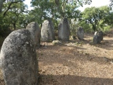
Neolithic and Bronze AgeSite Name: Tredinney CairnCountry: England County: Cornwall Type: Cairn
Nearest Town: Penzance Nearest Village: Crows-an-Wra
Map Ref: SW39222846
Latitude: 50.098856N Longitude: 5.647924W
Condition:
| 5 | Perfect |
| 4 | Almost Perfect |
| 3 | Reasonable but with some damage |
| 2 | Ruined but still recognisable as an ancient site |
| 1 | Pretty much destroyed, possibly visible as crop marks |
| 0 | No data. |
| -1 | Completely destroyed |
| 5 | Superb |
| 4 | Good |
| 3 | Ordinary |
| 2 | Not Good |
| 1 | Awful |
| 0 | No data. |
| 5 | Can be driven to, probably with disabled access |
| 4 | Short walk on a footpath |
| 3 | Requiring a bit more of a walk |
| 2 | A long walk |
| 1 | In the middle of nowhere, a nightmare to find |
| 0 | No data. |
| 5 | co-ordinates taken by GPS or official recorded co-ordinates |
| 4 | co-ordinates scaled from a detailed map |
| 3 | co-ordinates scaled from a bad map |
| 2 | co-ordinates of the nearest village |
| 1 | co-ordinates of the nearest town |
| 0 | no data |
Internal Links:
External Links:
I have visited· I would like to visit
Bladup JimChampion have visited here
")
Access Visible from the footpath across Tredinney Common between the National Trust's Chapel Carn Brea car park and Carn Euny. On private land, and guarded by cows.
You may be viewing yesterday's version of this page. To see the most up to date information please register for a free account.
")
")
")
")
")
")
")
")
")
")
")
")
")
")
Do not use the above information on other web sites or publications without permission of the contributor.
Click here to see more info for this site
Nearby sites
Key: Red: member's photo, Blue: 3rd party photo, Yellow: other image, Green: no photo - please go there and take one, Grey: site destroyed
Download sites to:
KML (Google Earth)
GPX (GPS waypoints)
CSV (Garmin/Navman)
CSV (Excel)
To unlock full downloads you need to sign up as a Contributory Member. Otherwise downloads are limited to 50 sites.
Turn off the page maps and other distractions
Nearby sites listing. In the following links * = Image available
548m W 268° Chapel Carn Brea Stones* Standing Stone (Menhir) (SW38672847)
617m NE 48° Bartine boulder cairn* Cairn (SW39702885)
689m W 260° Carn Brea Hut circles and Tumulus* Round Barrow(s) (SW3853428372)
747m SW 236° Chapel Carn Brea Tomb* Chambered Tomb (SW38582807)
763m WSW 243° Chapel Carn Brea Cairns* Barrow Cemetery (SW38522815)
806m SW 231° Chapel Carn Brea Long Cairn* Long Barrow (SW38572798)
808m NE 54° St Euny's Well Way Ancient Trackway (SW399289)
867m ENE 57° St Euny's Well (Carn Euny)* Holy Well or Sacred Spring (SW39972890)
894m SSE 157° Crows-an-Wra Cross* Ancient Cross (SW39532762)
897m NNE 11° Bartine Castle* Ancient Village or Settlement (SW39442933)
946m ESE 104° Brane Entrance Grave* Chambered Tomb (SW40132819)
1.1km ENE 66° Chapel Euny Well 2* Holy Well or Sacred Spring (SW40212885)
1.1km SW 218° Chycandra Settlement* Ancient Village or Settlement (SW38522766)
1.1km ESE 112° Brane Longbarrow* Artificial Mound (SW402280)
1.1km ENE 67° Carn Euny Village* Ancient Village or Settlement (SW40242883)
1.1km ENE 65° Carn Euny Fogou* Souterrain (Fogou, Earth House) (SW40242887)
1.1km SW 227° Kerrow chambered cairn* Chambered Cairn (SW38352773)
1.2km SE 137° Trevorgans Cross* Ancient Cross (SW39982755)
1.2km WSW 244° Chapel Carn Brea Menhir* Standing Stone (Menhir) (SW3812927987)
1.3km SSW 202° Treave Stonehenge* Modern Stone Circle etc (SW3869227316)
1.6km SE 124° Lower Leah Souterrain (Fogou, Earth House) (SW405275)
1.6km ENE 67° Caer Bran Hillfort* Hillfort (SW40742903)
1.7km NE 49° Grumbla* Chambered Cairn (SW40532948)
1.7km NNE 12° Leswidden stone* Ancient Cross (SW39653008)
1.7km E 79° Brane Cross* Ancient Cross (SW409287)
View more nearby sites and additional images


 We would like to know more about this location. Please feel free to add a brief description and any relevant information in your own language.
 Wir möchten mehr über diese Stätte erfahren. Bitte zögern Sie nicht, eine kurze Beschreibung und relevante Informationen in Deutsch hinzuzufügen.
 Nous aimerions en savoir encore un peu sur les lieux. S'il vous plaît n'hesitez pas à ajouter une courte description et tous les renseignements pertinents dans votre propre langue.
 Quisieramos informarnos un poco más de las lugares. No dude en añadir una breve descripción y otros datos relevantes en su propio idioma.