


<< Our Photo Pages >> Buaile Riabhach - Cairn in Scotland in Isle of Colonsay
Submitted by Andy B on Monday, 04 November 2002 Page Views: 9172
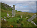
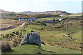
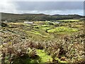
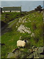
Neolithic and Bronze AgeSite Name: Buaile RiabhachCountry: Scotland County: Isle of Colonsay Type: Cairn
Map Ref: NR3884594358 Landranger Map Number: 61
Latitude: 56.070522N Longitude: 6.197852W
Condition:
| 5 | Perfect |
| 4 | Almost Perfect |
| 3 | Reasonable but with some damage |
| 2 | Ruined but still recognisable as an ancient site |
| 1 | Pretty much destroyed, possibly visible as crop marks |
| 0 | No data. |
| -1 | Completely destroyed |
| 5 | Superb |
| 4 | Good |
| 3 | Ordinary |
| 2 | Not Good |
| 1 | Awful |
| 0 | No data. |
| 5 | Can be driven to, probably with disabled access |
| 4 | Short walk on a footpath |
| 3 | Requiring a bit more of a walk |
| 2 | A long walk |
| 1 | In the middle of nowhere, a nightmare to find |
| 0 | No data. |
| 5 | co-ordinates taken by GPS or official recorded co-ordinates |
| 4 | co-ordinates scaled from a detailed map |
| 3 | co-ordinates scaled from a bad map |
| 2 | co-ordinates of the nearest village |
| 1 | co-ordinates of the nearest town |
| 0 | no data |
Internal Links:
External Links:
I have visited· I would like to visit
Flambeaux visited on 1st Jun 2027 - their rating: Cond: 2 Amb: 5 Access: 4 Its a beaut. Ruined yes and obviously was once a complete circle now with most tall stones removed. But somehow this matterred ittle to me for the tiny circumference of the circle is on an elevated cairn and the overall effect is that of a fairy knoll, proud and sad in the silence on the hillside.
SolarMegalith visited on 15th Feb 2023 - their rating: Cond: 3 Amb: 4 Access: 4
Andy B have visited here
Average ratings for this site from all visit loggers: Condition: 2.5 Ambience: 4.5 Access: 4
")
The archaeological sites that belong to the period spanning the later third millennium BC to the middle of the first millennium BC include burial cairns, cists, and standing stones as well as hut-circles and field-systems.
Little systematic work has been undertaken, and our information about the dates of most sites is very imperfect; the results of many of the excavations undertaken in the last century are inconclusive and the finds have frequently been lost. Two cairns probably contain central cist-burials of Bronze Age date. The unusual cairn at Scalasaig is, however, of less certain date; it may be related to the Late Bronze Age group known as kerb-cairns, or, as the finds possibly indicate, it could be much later. The absence of any accompanying grave-goods makes it difficult to be confident about the date of isolated cists; in several cases where the burial was indeed associated with pottery vessels or a flint object, the finds have been. subsequently lost.
The presence of groups of such burials at Lower Kilchattan and Uragaig, for example, probably indicates the location of small farming communities during the earlier part of the second millennium BC. There are two cup-markings at the mouth of a cave at Uamh na Mine, though their date is not certain; the decorated stone found in a cist at Lower Kilchattan cannot now be located. Of the standing stones on Colonsay, the most impressive are those at Lower Kilchattan known as 'Fingal's Limpet Hammers'.
The possibility that several of the standing stones have been used in connection with astronomical observations in prehistoric times has been raised on a number of occasions; archaeological evidence can neither prove nor disprove such suggestions, although the chronological span of the stones and the multiplicity of potential horizon-points that may be involved make such use unlikely. Stray finds of objects include an Early Bronze Age axe from Loch Fada and a Late Bronze Age sword from Beinn nan Gudairean.
From Colonsay & Oronsay - An Inventory of the Monuments extracted from Argyll Volume 5. (The Royal Commission on the Ancient and Historical Monuments of Scotland 1994)
More Colonsay History
You may be viewing yesterday's version of this page. To see the most up to date information please register for a free account.
")
")
")
Do not use the above information on other web sites or publications without permission of the contributor.
Nearby Images from Geograph Britain and Ireland:
©2009(licence)
©2017(licence)
©2023(licence)
©2023(licence)
©2008(licence)
The above images may not be of the site on this page, they are loaded from Geograph.
Please Submit an Image of this site or go out and take one for us!
Click here to see more info for this site
Nearby sites
Key: Red: member's photo, Blue: 3rd party photo, Yellow: other image, Green: no photo - please go there and take one, Grey: site destroyed
Download sites to:
KML (Google Earth)
GPX (GPS waypoints)
CSV (Garmin/Navman)
CSV (Excel)
To unlock full downloads you need to sign up as a Contributory Member. Otherwise downloads are limited to 50 sites.
Turn off the page maps and other distractions
Nearby sites listing. In the following links * = Image available
320m WSW 239° Scalasaig Farm Standing Stone (Menhir) (NR38569421)
623m N 352° Beinn Nan Gudairean Stone Fort or Dun (NR38809498)
623m W 269° Dun Eibhinn* Stone Fort or Dun (NR38229439)
625m SSW 194° Scalasaig South* Stone Circle (NR38669376)
630m E 95° Scalasaig Dun* Stone Fort or Dun (NR39479426)
949m S 172° Queens Bay Dun* Stone Fort or Dun (NR38929341)
1.1km SW 216° Dunan Leathan* Stone Fort or Dun (NR38119347)
2.2km W 281° Fingal's Limpet Hammers* Standing Stones (NR367949)
2.4km WSW 237° Machrins Stone* Sculptured Stone (NR36769320)
2.6km NNE 13° St Oran's Well (Colonsay) Holy Well or Sacred Spring (NR3959096818)
2.6km SSW 202° Dunan Nan Con* Stone Fort or Dun (NR37739201)
3.0km SSW 197° Dun Cholla* Stone Fort or Dun (NR3777091520)
3.1km WSW 257° Tobar Fuar* Stone Fort or Dun (NR35799384)
3.9km SW 214° Garvard Standing Stone Standing Stone (Menhir) (NR36479126)
4.2km WSW 249° Dun Gallain (Colonsay) Hillfort (NR34869314)
4.2km NE 36° Dunan Nan Nighean* Stone Fort or Dun (NR4155897608)
6.3km NNE 34° Cnoc A'Charragh Standing Stone (Menhir) (NR42669940)
6.3km SSW 209° Dun Domhnuill Stone Fort or Dun (NR35418902)
7.1km SSW 202° Oronsay Shell Middens* Ancient Village or Settlement (NR35828797)
24.1km SSW 202° Ardnave Loch* Crannog (NR28317263)
24.5km N 354° Ardalanish* Standing Stones (NM37841887)
24.8km ESE 116° Tarbert (Jura)* Standing Stone (Menhir) (NR6062782298)
24.9km S 186° Clach an Tiompain Standing Stone (Menhir) (NR34756977)
25.0km SSW 201° St Nem's Churchyard (Kilnave)* Ancient Cross (NR285715)
25.2km N 357° Uisken.* Standing Stone (Menhir) (NM3919119632)
View more nearby sites and additional images


 We would like to know more about this location. Please feel free to add a brief description and any relevant information in your own language.
 Wir möchten mehr über diese Stätte erfahren. Bitte zögern Sie nicht, eine kurze Beschreibung und relevante Informationen in Deutsch hinzuzufügen.
 Nous aimerions en savoir encore un peu sur les lieux. S'il vous plaît n'hesitez pas à ajouter une courte description et tous les renseignements pertinents dans votre propre langue.
 Quisieramos informarnos un poco más de las lugares. No dude en añadir una breve descripción y otros datos relevantes en su propio idioma.