 with our Megalithic Portal iPhone app")

<< Our Photo Pages >> Dun Totaig - Stone Fort or Dun in Scotland in Isle of Skye
Submitted by Andy B on Wednesday, 14 April 2010 Page Views: 3947
Multi-periodSite Name: Dun TotaigCountry: Scotland County: Isle of Skye Type: Stone Fort or Dun
Map Ref: NG237479
Latitude: 57.437079N Longitude: 6.606W
Condition:
| 5 | Perfect |
| 4 | Almost Perfect |
| 3 | Reasonable but with some damage |
| 2 | Ruined but still recognisable as an ancient site |
| 1 | Pretty much destroyed, possibly visible as crop marks |
| 0 | No data. |
| -1 | Completely destroyed |
| 5 | Superb |
| 4 | Good |
| 3 | Ordinary |
| 2 | Not Good |
| 1 | Awful |
| 0 | No data. |
| 5 | Can be driven to, probably with disabled access |
| 4 | Short walk on a footpath |
| 3 | Requiring a bit more of a walk |
| 2 | A long walk |
| 1 | In the middle of nowhere, a nightmare to find |
| 0 | No data. |
| 5 | co-ordinates taken by GPS or official recorded co-ordinates |
| 4 | co-ordinates scaled from a detailed map |
| 3 | co-ordinates scaled from a bad map |
| 2 | co-ordinates of the nearest village |
| 1 | co-ordinates of the nearest town |
| 0 | no data |
Internal Links:
External Links:
I have visited· I would like to visit
Andy B has visited here
")
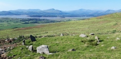
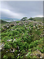
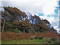
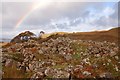
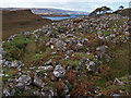
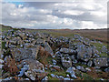
An excavated dun built on the summit of a small rocky ridge near Uiginish. It sits about 9m above the surrounding area and consists of several chambers and a well defined entranceway. The windswept trees behind evidence the exposed nature of the location.
The Highland Council Historic Environment Record describes this ruined dun as: "a mass of tumbled stone, sub-oval in shape measuring externally 89ft NW-SW and 48ft transversely. The thickness of the walling is indeterminate on the NW, but seems to be 18ft at the entrance and to vary from 15-23ft round the S arc, where one course only is traceable for a few yards. The entrance-passage is 4ft 10ins in width and is without checks. About 10ft from the entrance there is a cross-wall, only the ends of which remains projecting from the side walls."
You may be viewing yesterday's version of this page. To see the most up to date information please register for a free account.
")
")
")
Do not use the above information on other web sites or publications without permission of the contributor.
Nearby Images from Geograph Britain and Ireland:
©2023(licence)
©2009(licence)
©2007(licence)
©2009(licence)
©2009(licence)
The above images may not be of the site on this page, they are loaded from Geograph.
Please Submit an Image of this site or go out and take one for us!
Click here to see more info for this site
Nearby sites
Key: Red: member's photo, Blue: 3rd party photo, Yellow: other image, Green: no photo - please go there and take one, Grey: site destroyed
Download sites to:
KML (Google Earth)
GPX (GPS waypoints)
CSV (Garmin/Navman)
CSV (Excel)
To unlock full downloads you need to sign up as a Contributory Member. Otherwise downloads are limited to 50 sites.
Turn off the page maps and other distractions
Nearby sites listing. In the following links * = Image available
1.5km SSE 160° Dun Osdale Broch* Broch or Nuraghe (NG24124641)
1.6km NE 36° Dun Osdale Pictish Symbol Stone* Class I Pictish Symbol Stone (NG24734911)
2.5km NNW 345° Dun Fiadhairt* Broch or Nuraghe (NG232504)
3.8km SE 144° Dun Cnoc a'Sga* Stone Fort or Dun (NG257447)
3.8km SSW 199° Healabhal Mhor chambered cairn* Chambered Cairn (NG222444)
6.0km NNE 32° Temple of Anaitis (Waternish) Stone Circle (NG27255273)
6.0km N 357° Claigan* Souterrain (Fogou, Earth House) (NG238539)
6.2km NW 314° Clach Ard* Standing Stone (Menhir) (NG195525)
7.3km ESE 119° Vatten* Cairn (NG2983843987)
8.3km SE 128° Dun Feorlig* Broch or Nuraghe (NG299423)
8.4km SE 145° Dun Neill* Stone Fort or Dun (NG28114073)
9.0km ESE 123° Dun Abhuinn Bhaile Mheadhonaich* Stone Fort or Dun (NG309425)
11.4km N 6° Dun Hallin* Stone Fort or Dun (NG256592)
12.0km ENE 72° Dun Edinbane* Broch or Nuraghe (NG35355092)
12.4km ESE 111° Dun Arkaig* Broch or Nuraghe (NG350426)
12.7km ENE 60° Dun Flashader* Broch or Nuraghe (NG351536)
13.2km SE 136° Ullinish Lodge* Chambered Cairn (NG323378)
13.3km N 351° Heaven Stone* Standing Stone (Menhir) (NG22486122)
13.5km SE 130° Ullinish Souterrain Souterrain (Fogou, Earth House) (NG334385)
13.6km SE 127° Dun Mor (Struan)* Stone Fort or Dun (NG340390)
13.7km NE 51° Dun na h-Airde* Stone Fort or Dun (NG350558)
13.8km SE 128° Dun Beag (Struan)* Broch or Nuraghe (NG3395438630)
14.3km SE 132° Struanmore* Chambered Cairn (NG337376)
14.4km ENE 67° Dun Suladale* Broch or Nuraghe (NG374526)
14.8km ENE 63° Creagan Soillier* Stone Fort or Dun (NG37315378)
View more nearby sites and additional images


 We would like to know more about this location. Please feel free to add a brief description and any relevant information in your own language.
 Wir möchten mehr über diese Stätte erfahren. Bitte zögern Sie nicht, eine kurze Beschreibung und relevante Informationen in Deutsch hinzuzufügen.
 Nous aimerions en savoir encore un peu sur les lieux. S'il vous plaît n'hesitez pas à ajouter une courte description et tous les renseignements pertinents dans votre propre langue.
 Quisieramos informarnos un poco más de las lugares. No dude en añadir una breve descripción y otros datos relevantes en su propio idioma.