 with our Megalithic Portal iPhone app")


<< Our Photo Pages >> Totronald - Standing Stones in Scotland in Isle of Coll
Submitted by Tom_Bullock on Sunday, 06 October 2002 Page Views: 9593
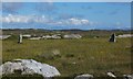
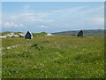
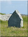
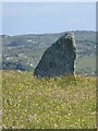
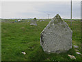
Neolithic and Bronze AgeSite Name: Totronald Alternative Name: Na SgialaicheanCountry: Scotland County: Isle of Coll Type: Standing Stones
Map Ref: NM1666455985 Landranger Map Number: 46
Latitude: 56.609801N Longitude: 6.619375W
Condition:
| 5 | Perfect |
| 4 | Almost Perfect |
| 3 | Reasonable but with some damage |
| 2 | Ruined but still recognisable as an ancient site |
| 1 | Pretty much destroyed, possibly visible as crop marks |
| 0 | No data. |
| -1 | Completely destroyed |
| 5 | Superb |
| 4 | Good |
| 3 | Ordinary |
| 2 | Not Good |
| 1 | Awful |
| 0 | No data. |
| 5 | Can be driven to, probably with disabled access |
| 4 | Short walk on a footpath |
| 3 | Requiring a bit more of a walk |
| 2 | A long walk |
| 1 | In the middle of nowhere, a nightmare to find |
| 0 | No data. |
| 5 | co-ordinates taken by GPS or official recorded co-ordinates |
| 4 | co-ordinates scaled from a detailed map |
| 3 | co-ordinates scaled from a bad map |
| 2 | co-ordinates of the nearest village |
| 1 | co-ordinates of the nearest town |
| 0 | no data |
Internal Links:
External Links:
I have visited· I would like to visit
DavidHoyle would like to visit
")
Circle diameter: 64 feet, Number of stones: 2
Standing about 5 feet tall, the two stones are oriented perpendicular to the line drawn between them.
Canmore site no. 21553.
You may be viewing yesterday's version of this page. To see the most up to date information please register for a free account.
")
Do not use the above information on other web sites or publications without permission of the contributor.
coldrum has found this location on Google Street View:
Nearby Images from Geograph Britain and Ireland:
©2015(licence)
©2022(licence)
©2022(licence)
©2022(licence)
©2008(licence)
The above images may not be of the site on this page, they are loaded from Geograph.
Please Submit an Image of this site or go out and take one for us!
Click here to see more info for this site
Nearby sites
Key: Red: member's photo, Blue: 3rd party photo, Yellow: other image, Green: no photo - please go there and take one, Grey: site destroyed
Download sites to:
KML (Google Earth)
GPX (GPS waypoints)
CSV (Garmin/Navman)
CSV (Excel)
To unlock full downloads you need to sign up as a Contributory Member. Otherwise downloads are limited to 50 sites.
Turn off the page maps and other distractions
Nearby sites listing. In the following links * = Image available
2.1km ENE 64° Cnoc nan Tota Standing Stone (Menhir) (NM1858956758)
2.6km NNE 29° Clach na Ban-righ Natural Stone / Erratic / Other Natural Feature (NM181582)
3.1km SSW 205° Traigh Chrossapol Standing Stone (Menhir) (NM1518853301)
5.4km E 91° Fiskary Bay Mesolithic Settlement Ancient Village or Settlement (NM221555)
5.9km NE 43° Arnabost Souterrain (Fogou, Earth House) (NM20966003)
11.7km SW 226° Caolas Standing Stone* Standing Stone (Menhir) (NM07744835)
11.7km SW 221° Dun Mor A'Chaolais* Broch or Nuraghe (NM084476)
13.7km WSW 237° Dun Beag (Vaul)* Stone Fort or Dun (NM04634926)
14.1km WSW 238° Dun Mor Vaul* Broch or Nuraghe (NM04234927)
15.7km WSW 239° Tiree Ringing Rock* Natural Stone / Erratic / Other Natural Feature (NM02684869)
15.8km SW 226° Dun Ghott* Stone Fort or Dun (NM04584567)
16.8km SW 227° Beinn Ghott* Cairn (NM03594540)
17.5km SW 227° Loch A' Bhleoghan* Stone Circle (NM030450)
17.6km SW 230° Loch A Chapuil* Stone Circle (NM024456)
17.7km SE 138° Dun Cruit Stone Fort or Dun (NM27634206)
17.9km SW 221° Dun Heanish* Stone Fort or Dun (NM039434)
18.2km SW 227° Dun Ibrig* Stone Fort or Dun (NM02594440)
18.7km ESE 113° Dun Haunn Stone Fort or Dun (NM33434749)
19.1km E 92° Port Na Caillich Stone Fort or Dun (NM35785408)
19.7km E 94° Lag Standing Stones* Standing Stones (NM3626753307)
20.2km ESE 105° Creag A' Chaisteal Rock Art (NM35874957)
20.3km E 94° Allt Cill Chriosd Stone Fort or Dun (NM36885328)
20.4km SW 236° Kenovay Cup-Marked Rocks Rock Art (NL99064560)
20.4km E 99° Calgary Pier Stone Fort or Dun (NM36705151)
21.1km E 93° Cillchriosd Rock Art (NM37665347)
View more nearby sites and additional images


 We would like to know more about this location. Please feel free to add a brief description and any relevant information in your own language.
 Wir möchten mehr über diese Stätte erfahren. Bitte zögern Sie nicht, eine kurze Beschreibung und relevante Informationen in Deutsch hinzuzufügen.
 Nous aimerions en savoir encore un peu sur les lieux. S'il vous plaît n'hesitez pas à ajouter une courte description et tous les renseignements pertinents dans votre propre langue.
 Quisieramos informarnos un poco más de las lugares. No dude en añadir una breve descripción y otros datos relevantes en su propio idioma.