 with our Megalithic Portal iPhone app")


<< Our Photo Pages >> Dun Borranais - Stone Fort or Dun in Scotland in Isle of Lewis
Submitted by SandyG on Monday, 08 September 2014 Page Views: 2560
Multi-periodSite Name: Dun BorranaisCountry: Scotland County: Isle of Lewis Type: Stone Fort or Dun
Map Ref: NB05033326
Latitude: 58.189174N Longitude: 7.021141W
Condition:
| 5 | Perfect |
| 4 | Almost Perfect |
| 3 | Reasonable but with some damage |
| 2 | Ruined but still recognisable as an ancient site |
| 1 | Pretty much destroyed, possibly visible as crop marks |
| 0 | No data. |
| -1 | Completely destroyed |
| 5 | Superb |
| 4 | Good |
| 3 | Ordinary |
| 2 | Not Good |
| 1 | Awful |
| 0 | No data. |
| 5 | Can be driven to, probably with disabled access |
| 4 | Short walk on a footpath |
| 3 | Requiring a bit more of a walk |
| 2 | A long walk |
| 1 | In the middle of nowhere, a nightmare to find |
| 0 | No data. |
| 5 | co-ordinates taken by GPS or official recorded co-ordinates |
| 4 | co-ordinates scaled from a detailed map |
| 3 | co-ordinates scaled from a bad map |
| 2 | co-ordinates of the nearest village |
| 1 | co-ordinates of the nearest town |
| 0 | no data |
Internal Links:
External Links:
I have visited· I would like to visit
rrmoser would like to visit
SandyG has visited here
")
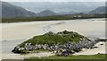
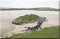
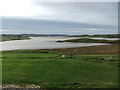
Occupying much a of tiny island towards the eastern end of a huge expanse of sand known as Tràigh Ùige is Dun Borranais. The outer wall of the building is still clearly visible and the entrance was probably in the NNW. The structure measures 15m by 13m and may have been D-shaped. The interior has been modified by the construction of two later shelters against the northern and southern walls. Access to the dun is via a causeway formed by large stepping stones. The setting of the site is spectacular even by Hebridean standards.
[Canmore ID 4031]
You may be viewing yesterday's version of this page. To see the most up to date information please register for a free account.
")
")
Do not use the above information on other web sites or publications without permission of the contributor.
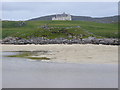
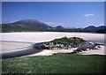
Nearby Images from Geograph Britain and Ireland:
©2011(licence)
©2021(licence)
©2008(licence)
©2007(licence)
©2016(licence)
The above images may not be of the site on this page, they are loaded from Geograph.
Please Submit an Image of this site or go out and take one for us!
Click here to see more info for this site
Nearby sites
Key: Red: member's photo, Blue: 3rd party photo, Yellow: other image, Green: no photo - please go there and take one, Grey: site destroyed
Download sites to:
KML (Google Earth)
GPX (GPS waypoints)
CSV (Garmin/Navman)
CSV (Excel)
To unlock full downloads you need to sign up as a Contributory Member. Otherwise downloads are limited to 50 sites.
Turn off the page maps and other distractions
Nearby sites listing. In the following links * = Image available
1.8km NW 305° Loch Cleidir Crannog (NB03653437)
5.6km ENE 60° Traigh Na Berie Stone Row / Alignment (NB10073571)
5.6km ENE 66° Traigh na Berie* Broch or Nuraghe (NB1035235177)
10.4km NE 52° Carnan Gibegeo Propped Stone CG1* Rock Outcrop (NB13653911)
10.4km NE 51° Carnan Gibegeo Propped Stone CG2* Rock Outcrop (NB13653913)
10.6km NE 50° Stiogha Chnap Propped Stone SC2* Rock Outcrop (NB13703947)
10.6km NE 50° Stiogha Chnap Propped Stone SC1* Rock Outcrop (NB1371539472)
10.6km NE 51° Carnan Gibegeo Propped Stone CG3* Rock Outcrop (NB13833932)
10.7km NE 51° Carnan Gibegeo Propped Stone CG4* Rock Outcrop (NB13843932)
10.8km ENE 73° Dun Baravat* Stone Fort or Dun (NB1559835563)
11.1km NE 48° Bosta Beach* Ancient Village or Settlement (NB138401)
11.4km E 81° Callanish 8* Stone Circle (NB16423424)
11.4km E 82° Callanish 8A* Standing Stone (Menhir) (NB165340)
11.7km E 81° Barraglom Cup-Marked Rock Rock Art (NB167343)
11.7km E 80° Dun Barraglom Broch or Nuraghe (NB16773435)
12.7km E 80° Callanish 15* Standing Stone (Menhir) (NB177345)
13.6km S 184° Aird Sleitenish Stone Circle (NB031198)
16.0km NE 56° Dun Carloway* Broch or Nuraghe (NB1900441224)
16.1km ENE 61° Dun Doune Braes* Stone Fort or Dun (NB1976039906)
16.2km ENE 78° Cnoc a Phrionnsa* Chambered Cairn (NB211355)
16.2km E 87° Callanish I* Stone Circle (NB2128633009)
16.2km E 87° Callanish* Stone Circle (NB2129833013)
16.2km E 84° Callanish 16* Standing Stone (Menhir) (NB213338)
16.4km E 83° Callanish 13* Standing Stones (NB215341)
16.5km E 80° Callanish 12* Standing Stone (Menhir) (NB2155634967)
View more nearby sites and additional images


 We would like to know more about this location. Please feel free to add a brief description and any relevant information in your own language.
 Wir möchten mehr über diese Stätte erfahren. Bitte zögern Sie nicht, eine kurze Beschreibung und relevante Informationen in Deutsch hinzuzufügen.
 Nous aimerions en savoir encore un peu sur les lieux. S'il vous plaît n'hesitez pas à ajouter une courte description et tous les renseignements pertinents dans votre propre langue.
 Quisieramos informarnos un poco más de las lugares. No dude en añadir una breve descripción y otros datos relevantes en su propio idioma.