


<< Our Photo Pages >> Dun Bharpa - Chambered Cairn in Scotland in Barra and Vatersay
Submitted by markj99 on Wednesday, 07 October 2020 Page Views: 908
Neolithic and Bronze AgeSite Name: Dun Bharpa Alternative Name: Dun BarpaCountry: Scotland
NOTE: This site is 3.6 km away from the location you searched for.
County: Barra and Vatersay Type: Chambered Cairn
Nearest Town: Castlebay Nearest Village: Borve
Map Ref: NF6719001910
Latitude: 56.988029N Longitude: 7.481656W
Condition:
| 5 | Perfect |
| 4 | Almost Perfect |
| 3 | Reasonable but with some damage |
| 2 | Ruined but still recognisable as an ancient site |
| 1 | Pretty much destroyed, possibly visible as crop marks |
| 0 | No data. |
| -1 | Completely destroyed |
| 5 | Superb |
| 4 | Good |
| 3 | Ordinary |
| 2 | Not Good |
| 1 | Awful |
| 0 | No data. |
| 5 | Can be driven to, probably with disabled access |
| 4 | Short walk on a footpath |
| 3 | Requiring a bit more of a walk |
| 2 | A long walk |
| 1 | In the middle of nowhere, a nightmare to find |
| 0 | No data. |
| 5 | co-ordinates taken by GPS or official recorded co-ordinates |
| 4 | co-ordinates scaled from a detailed map |
| 3 | co-ordinates scaled from a bad map |
| 2 | co-ordinates of the nearest village |
| 1 | co-ordinates of the nearest town |
| 0 | no data |
Internal Links:
External Links:
I have visited· I would like to visit
ravensidhe has visited here
")
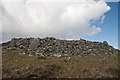
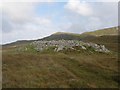
Dun Bharpa is a chambered cairn around 1 mile SE of Borve, Isle of Barra. It lies in a valley between Beinn Mhartainn and Grianan. Its relative isolation has not prevented some stone robbing and excavation of the cairn. Canmore ID 9734 lists 15 standing stones which formed part of the peristalith surrounding the cairn. The remaining stones vary in size from 5 to 7 foot high and 3 to 4.5 feet broad. The top of the cairn has been excavated exposing a possible capstone measuring 9 x 5 x 1 feet. The W of the cairn has been reduced to a grassy bank with scattered stones. Overall, Dun Bharpa is around 6 yards high by 30 yards across.
Directions: Exiting the ferry at Castlebay, turn L onto the A888 for Borgh. Follow the road for 2.75 miles until you reach Borve then continue for around 0.5 mile to the R turn into Craigston. Keep on this narrow road for 0.5 miles until it ends at a parking circle. Follow this track for around 0.5 mile until it ends. At this point Dun Bharpa lies 0.4 mile N & Balnacraig lies 450 yards ESE. Time has erased my memory of this route so if a path to either cairn presents itself you should take it.
You may be viewing yesterday's version of this page. To see the most up to date information please register for a free account.
")
")
")
Do not use the above information on other web sites or publications without permission of the contributor.
Nearby Images from Geograph Britain and Ireland:
©2012(licence)
©2014(licence)
©2006(licence)
©2006(licence)
©2016(licence)
The above images may not be of the site on this page, they are loaded from Geograph.
Please Submit an Image of this site or go out and take one for us!
Click here to see more info for this site
Nearby sites
Key: Red: member's photo, Blue: 3rd party photo, Yellow: other image, Green: no photo - please go there and take one, Grey: site destroyed
Download sites to:
KML (Google Earth)
GPX (GPS waypoints)
CSV (Garmin/Navman)
CSV (Excel)
To unlock full downloads you need to sign up as a Contributory Member. Otherwise downloads are limited to 50 sites.
Turn off the page maps and other distractions
Nearby sites listing. In the following links * = Image available
827m SE 144° Balnacraig Cairn Barra * Chambered Cairn (NF67620120)
1.7km NNW 328° Dun Cuier Broch or Nuraghe (NF6642003406)
1.8km WNW 296° Allasdale Dunes Cairn (NF65610283)
2.0km WSW 252° Borve Standing Stones* Standing Stones (NF65270144)
2.3km S 188° Tigh Clach Ancient Village or Settlement (NL667997)
3.2km SW 221° Tobar Chaluim Chille (Barra)* Holy Well or Sacred Spring (NL6492099654)
3.4km SE 145° Brevig* Standing Stones (NL689990)
5.1km SSW 210° Alt Christal, Tangaval Peninsula* Ancient Village or Settlement (NL64259773)
6.2km S 182° Cille Bhrianain* Misc. Earthwork (NL6644995702)
6.5km NNE 24° Kilbar (Isle of Barra)* Ancient Cross (NF703076)
6.6km NNE 27° Tobar Bharra* Holy Well or Sacred Spring (NF7061607538)
8.6km SSW 206° Ben Rulibreck Turf Maze (NL6275394560)
9.1km SSW 204° Cuithe Heillanish* Standing Stone (Menhir) (NL62779389)
11.0km SSW 193° Dun Sandray Broch or Nuraghe (NL638914)
11.6km S 191° Aird Pabbach Ancient Village or Settlement (NL64099066)
14.4km NNE 26° Pollachar* Standing Stone (Menhir) (NF745144)
15.8km SSW 200° Pabbay Class I Pictish Symbol Stone (NL607875)
18.3km NNE 18° Dun An Duichal Stone Fort or Dun (NF74311885)
18.6km NNE 19° Dun Na Killie Stone Fort or Dun (NF74611905)
19.3km NNE 14° Kilpheder Wheelhouse* Ancient Village or Settlement (NF733203)
20.9km NNE 12° Cladh Hallan* Ancient Village or Settlement (NF7313821977)
24.1km SSW 202° Barra Stone Circle Stone Circle (NL564803)
24.8km NNE 30° Carra Bhroin (Lochboisdale) Standing Stone (Menhir) (NF81172248)
25.4km NNE 14° Barp Reineval* Chambered Cairn (NF7549425972)
26.3km NNE 11° Dun in Loch na Muilne* Stone Fort or Dun (NF7445327237)
View more nearby sites and additional images


 We would like to know more about this location. Please feel free to add a brief description and any relevant information in your own language.
 Wir möchten mehr über diese Stätte erfahren. Bitte zögern Sie nicht, eine kurze Beschreibung und relevante Informationen in Deutsch hinzuzufügen.
 Nous aimerions en savoir encore un peu sur les lieux. S'il vous plaît n'hesitez pas à ajouter une courte description et tous les renseignements pertinents dans votre propre langue.
 Quisieramos informarnos un poco más de las lugares. No dude en añadir una breve descripción y otros datos relevantes en su propio idioma.