 with our Megalithic Portal iPhone app")

<< Our Photo Pages >> Morrel das Fadas - Passage Grave in France in Languedoc:Aude (11)
Submitted by TheCaptain on Friday, 14 July 2006 Page Views: 10568
Neolithic and Bronze AgeSite Name: Morrel das Fadas Alternative Name: Dolmen des Fades, Coteau des Fades, Palet de RolandCountry: France Département: Languedoc:Aude (11) Type: Passage Grave
Nearest Town: Carcassonne Nearest Village: Pépieux
Latitude: 43.312700N Longitude: 2.679700E
Condition:
| 5 | Perfect |
| 4 | Almost Perfect |
| 3 | Reasonable but with some damage |
| 2 | Ruined but still recognisable as an ancient site |
| 1 | Pretty much destroyed, possibly visible as crop marks |
| 0 | No data. |
| -1 | Completely destroyed |
| 5 | Superb |
| 4 | Good |
| 3 | Ordinary |
| 2 | Not Good |
| 1 | Awful |
| 0 | No data. |
| 5 | Can be driven to, probably with disabled access |
| 4 | Short walk on a footpath |
| 3 | Requiring a bit more of a walk |
| 2 | A long walk |
| 1 | In the middle of nowhere, a nightmare to find |
| 0 | No data. |
| 5 | co-ordinates taken by GPS or official recorded co-ordinates |
| 4 | co-ordinates scaled from a detailed map |
| 3 | co-ordinates scaled from a bad map |
| 2 | co-ordinates of the nearest village |
| 1 | co-ordinates of the nearest town |
| 0 | no data |
Internal Links:
External Links:
I have visited· I would like to visit
DrewParsons Mussa would like to visit
XIII visited on 6th Jun 2022 - their rating: Cond: 3 Amb: 5 Access: 4
J_W_R visited on 1st Jan 2019 - their rating: Cond: 4 Amb: 5 Access: 5
TheCaptain visited on 15th Sep 2005 - their rating: Cond: 4 Amb: 5 Access: 4 Visited again to get some pictures in the bright morning sun, although the sun doesn’t make it through the trees.
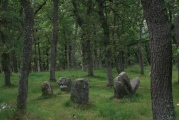
TheCaptain visited on 14th Sep 2005 - their rating: Cond: 4 Amb: 5 Access: 4 Although within the commune of Pépieux, this tremendous dolmen is actually nearer and easier to find from the village of Siran, from where you take the D.12 road east for a kilometre or so, and the mound is on the right, on top of a large natural pine covered hill amongst the vines. It is all rather obvious, and has a little parking area and signpost.
By far the biggest dolmen structure in the south of France, I cannot say how much of the hillock it is built on is natural, and how much is its tumulus, but nevertheless, it is a big structure. The chamber itself is 24 metres in length and up to 4 metres wide, aligned towards the southeast at 145°. This chamber is divided into three sections by lovely partitioned portal stones. The back section is rectangular, 4.5 metres long and 4 metres wide. The marvellous central section is 6.5 metres long, with massive side slab walls 2,5 metres high, which carry the single remaining large capstone (about 5m by 3.5m) well above head height.
Unfortunately the portal stones each side of this central chamber are broken, but enough remains to get a good feel for what was once here, as one of the stones of the southeastern portal is almost complete. The 13 metres of entranceway is made with alternating slabs and dry stone walling, and narrows down to about 2 metres wide at the entrance. This really is a fantastic place to visit, but difficult to photograph because of its size and all the surrounding trees.
johnstone visited on 20th Jul 2001 - their rating: Cond: 3 Amb: 5 Access: 4
TheCaptain visited on 13th Aug 2000 - their rating: Cond: 4 Amb: 5 Access: 4 Day out from Toulouse to explore Minerve ancient village, Rock tunnels, Morrel das Fadas, St Eugene. On a little hill covered in pines to the south of the D52 road to the northeast of Carcassonne is found the remains of this teriffic allée couverte, the hill of the fairies, said to be the largest in southern France.
regina neolithique02 have visited here
Average ratings for this site from all visit loggers: Condition: 3.67 Ambience: 5 Access: 4.17
")
Within the remains of its mound, the stone lined allée is 24 metres in length, and about 3 metres in width. Only a single large capstone remains in place, near to the centre. Within the remains of the allée are two portals, each constructed from two stone slabs, with semi ovoid entrance holes cut into each, which togteher would create an oval shaped entrance.
Unfortunately, as with most of the rest of the structure, most of these stones have been broken and their tops are lost. However, this is still a fantastic place to visit.
Base Mérimée (Historic Monument)
You may be viewing yesterday's version of this page. To see the most up to date information please register for a free account.
")
")
")
")
")
")
")
")
")
")
")
")
")
")
")
")
")
")
")
")
Do not use the above information on other web sites or publications without permission of the contributor.
Click here to see more info for this site
Nearby sites
Click here to view sites on an interactive map of the areaKey: Red: member's photo, Blue: 3rd party photo, Yellow: other image, Green: no photo - please go there and take one, Grey: site destroyed
Download sites to:
KML (Google Earth)
GPX (GPS waypoints)
CSV (Garmin/Navman)
CSV (Excel)
To unlock full downloads you need to sign up as a Contributory Member. Otherwise downloads are limited to 50 sites.
Turn off the page maps and other distractions
Nearby sites listing. In the following links * = Image available
1.7km SSW 200° Morrel das Fadas replica* Modern Stone Circle etc
2.8km NW 307° Dolmen de Centeilles* Burial Chamber or Dolmen
2.9km NNW 336° Pic St-Martin Camp Gallo-Romain* Hillfort
3.1km ENE 66° Grotte d'Aldène Cave or Rock Shelter
3.6km ENE 72° Cupules de Saint-Salvy Rock Art
3.8km N 2° Dolmen de Fournes 2 Burial Chamber or Dolmen
3.8km N 2° Menhir de Fournès Standing Stone (Menhir)
4.1km N 0° Dolmen de Fournes 1 Burial Chamber or Dolmen
4.2km NNW 329° Mousse Dolmen 3 Burial Chamber or Dolmen
4.2km NNW 328° Mousse Dolmen 2 Burial Chamber or Dolmen
4.2km NNW 333° Mousse Dolmen 1* Burial Chamber or Dolmen
4.2km NE 53° La Cigalière Dolmen* Burial Chamber or Dolmen
4.3km NE 42° Montcelebre* Standing Stone (Menhir)
4.3km NNW 342° Dolmen de Lauriol 1* Burial Chamber or Dolmen
4.6km NNW 330° Mousse Dolmen 4 Burial Chamber or Dolmen
4.8km NNE 18° Grotte d'Aldène Cave or Rock Shelter
4.8km NNW 337° Dolmen de Lauriol 2 Burial Chamber or Dolmen
4.9km NNW 336° Dolmen de Lauriol 3 Burial Chamber or Dolmen
4.9km N 357° Dolmen de la Fôret 2 Burial Chamber or Dolmen
4.9km WNW 296° Calamiac dolmen Burial Chamber or Dolmen
4.9km NNE 23° Minerve la Vieille* Ancient Village or Settlement
5.0km SE 128° Oppidum protohistorique Ancient Village or Settlement
5.0km NNW 329° Dolmen de Peyro Rousso Burial Chamber or Dolmen
5.1km NNW 339° Dolmen de Castel Bouqui Est Burial Chamber or Dolmen
5.2km N 354° Dolmen de la Fôret 1* Burial Chamber or Dolmen
View more nearby sites and additional images


 We would like to know more about this location. Please feel free to add a brief description and any relevant information in your own language.
 Wir möchten mehr über diese Stätte erfahren. Bitte zögern Sie nicht, eine kurze Beschreibung und relevante Informationen in Deutsch hinzuzufügen.
 Nous aimerions en savoir encore un peu sur les lieux. S'il vous plaît n'hesitez pas à ajouter une courte description et tous les renseignements pertinents dans votre propre langue.
 Quisieramos informarnos un poco más de las lugares. No dude en añadir una breve descripción y otros datos relevantes en su propio idioma.