


<< Our Photo Pages >> Menhir du Mené - Standing Stone (Menhir) in France in Bretagne:Morbihan (56)
Submitted by TheCaptain on Monday, 03 January 2005 Page Views: 3781
Neolithic and Bronze AgeSite Name: Menhir du Mené Alternative Name: Menhir de BotergalCountry: France Département: Bretagne:Morbihan (56) Type: Standing Stone (Menhir)
Nearest Town: Vannes Nearest Village: Moustoir-Ac
Latitude: 47.837400N Longitude: 2.8508W
Condition:
| 5 | Perfect |
| 4 | Almost Perfect |
| 3 | Reasonable but with some damage |
| 2 | Ruined but still recognisable as an ancient site |
| 1 | Pretty much destroyed, possibly visible as crop marks |
| 0 | No data. |
| -1 | Completely destroyed |
| 5 | Superb |
| 4 | Good |
| 3 | Ordinary |
| 2 | Not Good |
| 1 | Awful |
| 0 | No data. |
| 5 | Can be driven to, probably with disabled access |
| 4 | Short walk on a footpath |
| 3 | Requiring a bit more of a walk |
| 2 | A long walk |
| 1 | In the middle of nowhere, a nightmare to find |
| 0 | No data. |
| 5 | co-ordinates taken by GPS or official recorded co-ordinates |
| 4 | co-ordinates scaled from a detailed map |
| 3 | co-ordinates scaled from a bad map |
| 2 | co-ordinates of the nearest village |
| 1 | co-ordinates of the nearest town |
| 0 | no data |
Internal Links:
External Links:
I have visited· I would like to visit
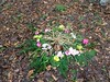
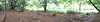
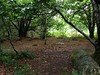
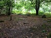
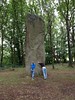
TheCaptain visited on 12th Jul 2005 - their rating: Cond: 3 Amb: 3 Access: 5 This tall thin menhir is built into a roadside bank, and is more than 4 metres tall from the top of that. If the ground level is at the road level, the menhir would be 7 metres tall. It is difficult to get to see due to all the undergrowth, but when round the back, in amongst the brambles, it looks like it has a crook carved onto it.
Ogham have visited here
")
It is difficult to get to see due to all the undergrowth, but when round the back, in amongst the brambles, it looks like it has a crook carved onto it.
Wikipedia article Liste des sites mégalithiques du Morbihan
You may be viewing yesterday's version of this page. To see the most up to date information please register for a free account.
")
")
")
Do not use the above information on other web sites or publications without permission of the contributor.
Nearby Images from Flickr

The above images may not be of the site on this page, but were taken nearby. They are loaded from Flickr so please click on them for image credits.
Click here to see more info for this site
Nearby sites
Click here to view sites on an interactive map of the areaKey: Red: member's photo, Blue: 3rd party photo, Yellow: other image, Green: no photo - please go there and take one, Grey: site destroyed
Download sites to:
KML (Google Earth)
GPX (GPS waypoints)
CSV (Garmin/Navman)
CSV (Excel)
To unlock full downloads you need to sign up as a Contributory Member. Otherwise downloads are limited to 50 sites.
Turn off the page maps and other distractions
Nearby sites listing. In the following links * = Image available
496m WNW 289° Mégalithe-siège, Kerhero* Natural Stone / Erratic / Other Natural Feature
896m W 277° Pierres de Kerguéris* Natural Stone / Erratic / Other Natural Feature
1.4km NNW 335° Kermorvan Dolmen* Burial Chamber or Dolmen
1.5km SSW 203° Kermarquer menhir* Standing Stone (Menhir)
1.6km SSW 208° Men-Brasi-de-Kermar-Ker* Standing Stone (Menhir)
1.7km SSW 195° Kerara Menhir* Standing Stone (Menhir)
2.7km WSW 244° Cosquéro Menhir* Standing Stone (Menhir)
3.3km WSW 239° Menhir de Kerigo Standing Stone (Menhir)
4.9km ENE 72° Bézo menhir* Standing Stone (Menhir)
5.6km SE 130° Larcuste cairns 1* Chambered Cairn
5.6km SE 130° Larcuste Cairns* Chambered Cairn
5.6km SE 130° Larcuste cairns 2* Chambered Cairn
5.6km SE 130° Larcuste cairns 3* Chambered Cairn
5.7km SSE 156° Cairn de Lost-er-Lenn Cairn
6.1km E 97° Kerjagu Menhirs* Standing Stones
6.1km E 98° Kerjagu allée couverte* Passage Grave
6.2km NE 43° Kergonfalz Tumulus* Chambered Tomb
6.2km NE 44° Kergonfalz allée couverte* Passage Grave
7.0km W 273° Dolmen de Roh Du 2 Burial Chamber or Dolmen
7.0km SSE 153° Ty Neüé menhir couché* Standing Stone (Menhir)
7.1km W 272° Dolmen de Roh Du 1* Burial Chamber or Dolmen
7.2km WSW 253° Dolmen de Soucho Burial Chamber or Dolmen
7.6km W 272° Dolmen de Roh Du 3 Burial Chamber or Dolmen
7.9km ESE 112° Goh Menhir menhir* Standing Stone (Menhir)
7.9km W 260° Menhir dit la Croix Blanche (Morbihan) Standing Stone (Menhir)
View more nearby sites and additional images


 We would like to know more about this location. Please feel free to add a brief description and any relevant information in your own language.
 Wir möchten mehr über diese Stätte erfahren. Bitte zögern Sie nicht, eine kurze Beschreibung und relevante Informationen in Deutsch hinzuzufügen.
 Nous aimerions en savoir encore un peu sur les lieux. S'il vous plaît n'hesitez pas à ajouter une courte description et tous les renseignements pertinents dans votre propre langue.
 Quisieramos informarnos un poco más de las lugares. No dude en añadir una breve descripción y otros datos relevantes en su propio idioma.