


<< Our Photo Pages >> La Pièce Couverte - Passage Grave in France in Bretagne:Morbihan (56)
Submitted by TheCaptain on Monday, 03 January 2005 Page Views: 2783
Neolithic and Bronze AgeSite Name: La Pièce Couverte Alternative Name: Clos Boscher allée couverteCountry: France Département: Bretagne:Morbihan (56) Type: Passage Grave
Nearest Town: Ploërmel Nearest Village: Monteneuf
Latitude: 47.872232N Longitude: 2.188408W
Condition:
| 5 | Perfect |
| 4 | Almost Perfect |
| 3 | Reasonable but with some damage |
| 2 | Ruined but still recognisable as an ancient site |
| 1 | Pretty much destroyed, possibly visible as crop marks |
| 0 | No data. |
| -1 | Completely destroyed |
| 5 | Superb |
| 4 | Good |
| 3 | Ordinary |
| 2 | Not Good |
| 1 | Awful |
| 0 | No data. |
| 5 | Can be driven to, probably with disabled access |
| 4 | Short walk on a footpath |
| 3 | Requiring a bit more of a walk |
| 2 | A long walk |
| 1 | In the middle of nowhere, a nightmare to find |
| 0 | No data. |
| 5 | co-ordinates taken by GPS or official recorded co-ordinates |
| 4 | co-ordinates scaled from a detailed map |
| 3 | co-ordinates scaled from a bad map |
| 2 | co-ordinates of the nearest village |
| 1 | co-ordinates of the nearest town |
| 0 | no data |
Internal Links:
External Links:
I have visited· I would like to visit
aolson visited on 19th Jul 2020 - their rating: Cond: 2 Amb: 4 Access: 3 It is possible to drive fairly close, depending how much dust / mud you are willing to get on your vehicle.
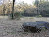
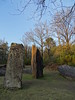
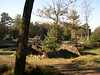
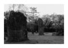
TheCaptain couldn't find on 9th Jul 2005 This is now not much more than a line of a dozen or so slabs positoned in a line of about 10 metres length, and is probably the remains of an allée couverte. Several of the slabs are marked with cupules and symbols.
negus visited - their rating: Cond: 3
Average ratings for this site from all visit loggers: Condition: 2.5
")
Several of the slabs are marked with cupules and symbols.
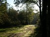
Can be found along marked footpaths through the forest from Les Pierres Droites.
You may be viewing yesterday's version of this page. To see the most up to date information please register for a free account.
")
Do not use the above information on other web sites or publications without permission of the contributor.
Nearby Images from Flickr
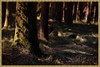
The above images may not be of the site on this page, but were taken nearby. They are loaded from Flickr so please click on them for image credits.
Click here to see more info for this site
Nearby sites
Click here to view sites on an interactive map of the areaKey: Red: member's photo, Blue: 3rd party photo, Yellow: other image, Green: no photo - please go there and take one, Grey: site destroyed
Download sites to:
KML (Google Earth)
GPX (GPS waypoints)
CSV (Garmin/Navman)
CSV (Excel)
To unlock full downloads you need to sign up as a Contributory Member. Otherwise downloads are limited to 50 sites.
Turn off the page maps and other distractions
Nearby sites listing. In the following links * = Image available
376m NW 325° La Roche Blanche* Round Cairn
799m S 180° Sépulture de Bécihan* Passage Grave
1.1km ENE 68° Les Bordouès* Passage Grave
1.1km N 10° Pierres Droites (Monteneuf)* Stone Row / Alignment
1.1km N 11° Centre Les Landes* Museum
1.5km WNW 298° Megalithes de Étang du Chaperon Rouge* Passage Grave
1.8km WNW 298° Allée Couverte du Chaperon Rouge Passage Grave
1.8km NNW 343° La Loge Morinais* Passage Grave
2.0km NNW 333° Lande de Rousse* Standing Stones
2.4km NW 307° Allée Couverte dite Château d'Eau Passage Grave
2.6km NE 34° Chomet de Coëtplan* Stone Row / Alignment
2.9km N 10° La Verrie menhir* Standing Stone (Menhir)
3.2km NE 45° Rocher Maheux* Passage Grave
3.8km SW 215° Dolmen de Madry Burial Chamber or Dolmen
3.9km N 4° Allée Couverte dite le Tombeau des Rochettes Passage Grave
5.8km SE 139° Menhir de Brambe Standing Stone (Menhir)
7.0km WNW 286° Allée couverte dite la Roche des Fées* Passage Grave
7.7km NNW 327° Allée couverte dite de Roherman* Passage Grave
7.7km ESE 115° Alignement de la Saude Stone Row / Alignment
8.0km ESE 109° Cromlech du Bois de Léron Stone Circle
8.0km ESE 109° Dolmen du Bois de Léron Burial Chamber or Dolmen
9.0km WSW 251° Bodel Menhir* Standing Stone (Menhir)
9.0km WSW 250° Allée Couverte du Haut Bodel* Passage Grave
9.8km NNW 326° Allée Couverte de Brambelay Passage Grave
10.4km S 184° Allée couverte du Sigré* Passage Grave
View more nearby sites and additional images


 We would like to know more about this location. Please feel free to add a brief description and any relevant information in your own language.
 Wir möchten mehr über diese Stätte erfahren. Bitte zögern Sie nicht, eine kurze Beschreibung und relevante Informationen in Deutsch hinzuzufügen.
 Nous aimerions en savoir encore un peu sur les lieux. S'il vous plaît n'hesitez pas à ajouter une courte description et tous les renseignements pertinents dans votre propre langue.
 Quisieramos informarnos un poco más de las lugares. No dude en añadir una breve descripción y otros datos relevantes en su propio idioma.