

<< Our Photo Pages >> Alignement de Lostmarc'h 1 - Stone Row / Alignment in France in Bretagne:Finistère (29)
Submitted by TheCaptain on Tuesday, 28 December 2004 Page Views: 4144
Neolithic and Bronze AgeSite Name: Alignement de Lostmarc'h 1Country: France Département: Bretagne:Finistère (29) Type: Stone Row / Alignment
Nearest Town: Crozon Peninsula Nearest Village: Crozon
Latitude: 48.216600N Longitude: 4.5538W
Condition:
| 5 | Perfect |
| 4 | Almost Perfect |
| 3 | Reasonable but with some damage |
| 2 | Ruined but still recognisable as an ancient site |
| 1 | Pretty much destroyed, possibly visible as crop marks |
| 0 | No data. |
| -1 | Completely destroyed |
| 5 | Superb |
| 4 | Good |
| 3 | Ordinary |
| 2 | Not Good |
| 1 | Awful |
| 0 | No data. |
| 5 | Can be driven to, probably with disabled access |
| 4 | Short walk on a footpath |
| 3 | Requiring a bit more of a walk |
| 2 | A long walk |
| 1 | In the middle of nowhere, a nightmare to find |
| 0 | No data. |
| 5 | co-ordinates taken by GPS or official recorded co-ordinates |
| 4 | co-ordinates scaled from a detailed map |
| 3 | co-ordinates scaled from a bad map |
| 2 | co-ordinates of the nearest village |
| 1 | co-ordinates of the nearest town |
| 0 | no data |
Internal Links:
External Links:
I have visited· I would like to visit
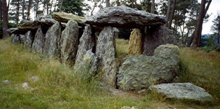
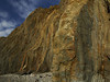
TheCaptain visited on 19th Jun 2005 - their rating: Cond: 3 Amb: 4 Access: 3 What I could find of the Lostmarc'h alignements, on top of a headland overlooking the Atlantic Ocean with a fine surf beach below to the south, was a line of eight stones aligned at an angle of 060°/240° running across the headland. None of the stones are much more than a metre in height, and they are spaced about 6 metres apart from each other. There are several other stones laying about, perhaps the remains of other rows.
Further out on the headland are a lot more stones at N48.2150° W4.5561°. Its hard to make out any clear pattern, but its possibly the remains of at least 4 rows. Further stones can be seen dotted about all over the place. Perhaps this was once a big important centre.
johnstone visited on 19th Jun 2003 - their rating: Cond: 3 Amb: 4 Access: 4
Average ratings for this site from all visit loggers: Condition: 3 Ambience: 4 Access: 3.5
")
None of the stones are much more than a metre in height, and they are spaced about 6 metres apart from each other. There are several other stones laying about, perhaps the remains of other rows.
Further out on the headland are a lot more stones at N48.2150° W4.5561°. Its hard to make out any clear pattern, but its possibly the remains of at least 4 rows. Further stones can be seen dotted about all over the place.
Perhaps this was once a big important centre.
Base Mérimée (Historic Monument)
You may be viewing yesterday's version of this page. To see the most up to date information please register for a free account.
")
")
Do not use the above information on other web sites or publications without permission of the contributor.
Nearby Images from Flickr


The above images may not be of the site on this page, but were taken nearby. They are loaded from Flickr so please click on them for image credits.
Click here to see more info for this site
Nearby sites
Click here to view sites on an interactive map of the areaKey: Red: member's photo, Blue: 3rd party photo, Yellow: other image, Green: no photo - please go there and take one, Grey: site destroyed
Download sites to:
KML (Google Earth)
GPX (GPS waypoints)
CSV (Garmin/Navman)
CSV (Excel)
To unlock full downloads you need to sign up as a Contributory Member. Otherwise downloads are limited to 50 sites.
Turn off the page maps and other distractions
Nearby sites listing. In the following links * = Image available
27m SSW 214° Lostmarc'h menhir* Standing Stone (Menhir)
414m ENE 59° Alignement de Lostmarc'h 2 Stone Row / Alignment
454m SSW 208° Oppidum de la Pointe de Lostmarc'h* Promontory Fort / Cliff Castle
494m SSW 209° Dolmen de la Pointe de Lost Marc'h* Chambered Cairn
1.1km S 180° Kastell Inizig Promontory Fort / Cliff Castle
1.1km NE 54° Menhir de Kerellot 1 Standing Stone (Menhir)
1.1km NE 51° Menhir de Kerellot 2 Standing Stone (Menhir)
1.7km NE 44° Dolmen de Tromel Burial Chamber or Dolmen
2.0km NNE 29° Dolmen de an Drustel Burial Chamber or Dolmen
2.0km NNW 335° Alignement de la Pointe de Dinan Stone Row / Alignment
2.0km SSE 159° Dolmen de Kerdreux* Burial Chamber or Dolmen
2.1km NNW 333° Dolmen de la Pointe de Dinan* Burial Chamber or Dolmen
2.1km SSE 156° Menhir de Kerdreux Standing Stone (Menhir)
2.8km SSE 167° Menhir dit Ar Men Vras Zalous Standing Stone (Menhir)
2.9km S 172° Alignement de Menesguen Stone Row / Alignment
3.0km NE 47° Menhir de Belbeoch Standing Stone (Menhir)
3.0km NNE 22° Menhir de Goulien Standing Stone (Menhir)
3.0km E 98° Alignements de Ty-ar-C'huré* Stone Row / Alignment
3.1km S 173° Dolmen de Persig Burial Chamber or Dolmen
3.7km SSE 158° Dolmen de Rostudel* Burial Chamber or Dolmen
5.1km NE 48° Menhir de Crozon Standing Stone (Menhir)
5.4km NE 56° Menhir dit Pierre du Cerceuil Standing Stone (Menhir)
5.5km ENE 59° Menhir ar Men Bris Standing Stone (Menhir)
5.8km NNW 329° Quadrilatère de Pen ar Yeun* Stone Circle
6.1km ENE 68° La Républicaine* Standing Stone (Menhir)
View more nearby sites and additional images


 We would like to know more about this location. Please feel free to add a brief description and any relevant information in your own language.
 Wir möchten mehr über diese Stätte erfahren. Bitte zögern Sie nicht, eine kurze Beschreibung und relevante Informationen in Deutsch hinzuzufügen.
 Nous aimerions en savoir encore un peu sur les lieux. S'il vous plaît n'hesitez pas à ajouter une courte description et tous les renseignements pertinents dans votre propre langue.
 Quisieramos informarnos un poco más de las lugares. No dude en añadir una breve descripción y otros datos relevantes en su propio idioma.