

<< Our Photo Pages >> Kerpeulven Menhir (Penvénan) - Standing Stone (Menhir) in France in Bretagne:Côtes-D'Armor (22)
Submitted by TheCaptain on Sunday, 19 December 2004 Page Views: 3564
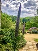
Neolithic and Bronze AgeSite Name: Kerpeulven Menhir (Penvénan) Alternative Name: Menhir de KerbelvenCountry: France Département: Bretagne:Côtes-D'Armor (22) Type: Standing Stone (Menhir)
Nearest Town: Tréguier Nearest Village: Penvénan
Latitude: 48.813852N Longitude: 3.294158W
Condition:
| 5 | Perfect |
| 4 | Almost Perfect |
| 3 | Reasonable but with some damage |
| 2 | Ruined but still recognisable as an ancient site |
| 1 | Pretty much destroyed, possibly visible as crop marks |
| 0 | No data. |
| -1 | Completely destroyed |
| 5 | Superb |
| 4 | Good |
| 3 | Ordinary |
| 2 | Not Good |
| 1 | Awful |
| 0 | No data. |
| 5 | Can be driven to, probably with disabled access |
| 4 | Short walk on a footpath |
| 3 | Requiring a bit more of a walk |
| 2 | A long walk |
| 1 | In the middle of nowhere, a nightmare to find |
| 0 | No data. |
| 5 | co-ordinates taken by GPS or official recorded co-ordinates |
| 4 | co-ordinates scaled from a detailed map |
| 3 | co-ordinates scaled from a bad map |
| 2 | co-ordinates of the nearest village |
| 1 | co-ordinates of the nearest town |
| 0 | no data |
Internal Links:
External Links:
I have visited· I would like to visit
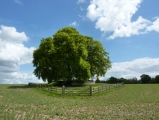
TheCaptain visited on 25th Jun 2005 - their rating: Cond: 3 Amb: 2 Access: 5 This pleasant menhir is about 4 metres tall, and trapped in a garden about 250 metres north of the church along Rue de Menhir in the village of Penvénan. It is however only a few metres from the road, and easily visible from it.
johnstone visited on 21st Jun 2005 - their rating: Cond: 4 Amb: 3 Access: 5
Average ratings for this site from all visit loggers: Condition: 3.5 Ambience: 2.5 Access: 5
 (PID:30076)")
Base Mérimée (Historic Monument)
Wikipedia article
Liste des sites mégalithiques des Côtes-d'Armor
You may be viewing yesterday's version of this page. To see the most up to date information please register for a free account.
 (PID:190522)")
 (PID:30077)")
 (PID:190519)")
 (PID:186346)")
Do not use the above information on other web sites or publications without permission of the contributor.
Nearby Images from Flickr


The above images may not be of the site on this page, but were taken nearby. They are loaded from Flickr so please click on them for image credits.
Click here to see more info for this site
Nearby sites
Click here to view sites on an interactive map of the areaKey: Red: member's photo, Blue: 3rd party photo, Yellow: other image, Green: no photo - please go there and take one, Grey: site destroyed
Download sites to:
KML (Google Earth)
GPX (GPS waypoints)
CSV (Garmin/Navman)
CSV (Excel)
To unlock full downloads you need to sign up as a Contributory Member. Otherwise downloads are limited to 50 sites.
Turn off the page maps and other distractions
Nearby sites listing. In the following links * = Image available
772m WNW 282° Menhir de Kerbriand* Standing Stone (Menhir)
840m NNW 336° Menhir de Kermarker* Standing Stone (Menhir)
1.2km NE 43° Tossen-Keler Cromlech (post 2018)* Stone Circle
1.2km NE 43° Coffre de Roch Glaz* Cist
1.6km N 4° Menhir de Crec'h Bleiz Standing Stone (Menhir)
1.8km NNW 332° Menhir de Kervéniou* Standing Stone (Menhir)
1.9km WNW 301° Menhir de Kergastel* Standing Stone (Menhir)
2.3km SSW 206° Tossen-Keler Tumulus* Chambered Tomb
3.4km NNW 343° Dolmen de l'Ile-Saint-Gildas Burial Chamber or Dolmen
3.9km WSW 252° Coat Mez allée couverte* Passage Grave
4.8km E 101° Menhir de Kerriou* Standing Stone (Menhir)
4.9km SW 218° Menhir du Run* Standing Stone (Menhir)
4.9km NE 41° Kergonet menhir* Standing Stone (Menhir)
5.5km S 174° Menhir de Kerfos Standing Stone (Menhir)
5.5km E 86° Menhir de Kerloc'h* Standing Stone (Menhir)
5.8km NE 36° Rocher de Napoléon* Natural Stone / Erratic / Other Natural Feature
5.9km ESE 120° Tossen-Keler Cromlech (1964-2018)* Stone Circle
8.0km SSE 167° Camp de Castel-Du Ancient Village or Settlement
8.8km WSW 256° Stèle de Louannec* Standing Stone (Menhir)
9.0km ENE 69° Men-ar-Rompet* Passage Grave
10.7km WSW 244° Dolmen dit le Lit de Saint-Yves* Burial Chamber or Dolmen
12.0km WSW 247° Crec'h Quillé* Passage Grave
13.2km S 179° Manoir de Coadélan menhir* Standing Stone (Menhir)
13.8km ENE 68° Tour-ar-Varquez* Stone Row / Alignment
14.0km W 281° Rochers de Ploumanac'h* Natural Stone / Erratic / Other Natural Feature
View more nearby sites and additional images


 We would like to know more about this location. Please feel free to add a brief description and any relevant information in your own language.
 Wir möchten mehr über diese Stätte erfahren. Bitte zögern Sie nicht, eine kurze Beschreibung und relevante Informationen in Deutsch hinzuzufügen.
 Nous aimerions en savoir encore un peu sur les lieux. S'il vous plaît n'hesitez pas à ajouter une courte description et tous les renseignements pertinents dans votre propre langue.
 Quisieramos informarnos un poco más de las lugares. No dude en añadir una breve descripción y otros datos relevantes en su propio idioma.