


<< Our Photo Pages >> Old Fulling Mill Museum of Archaeology - Museum in England in County Durham
Submitted by durhamnature on Saturday, 30 November 2002 Page Views: 6908
MuseumsSite Name: Old Fulling Mill Museum of ArchaeologyCountry: England County: County Durham Type: Museum
Nearest Town: Durham
Map Ref: NZ272420 Landranger Map Number: 88
Latitude: 54.772189N Longitude: 1.578717W
Condition:
| 5 | Perfect |
| 4 | Almost Perfect |
| 3 | Reasonable but with some damage |
| 2 | Ruined but still recognisable as an ancient site |
| 1 | Pretty much destroyed, possibly visible as crop marks |
| 0 | No data. |
| -1 | Completely destroyed |
| 5 | Superb |
| 4 | Good |
| 3 | Ordinary |
| 2 | Not Good |
| 1 | Awful |
| 0 | No data. |
| 5 | Can be driven to, probably with disabled access |
| 4 | Short walk on a footpath |
| 3 | Requiring a bit more of a walk |
| 2 | A long walk |
| 1 | In the middle of nowhere, a nightmare to find |
| 0 | No data. |
| 5 | co-ordinates taken by GPS or official recorded co-ordinates |
| 4 | co-ordinates scaled from a detailed map |
| 3 | co-ordinates scaled from a bad map |
| 2 | co-ordinates of the nearest village |
| 1 | co-ordinates of the nearest town |
| 0 | no data |
Internal Links:
External Links:
I have visited· I would like to visit
Anne T visited on 30th Apr 2017 - their rating: Cond: 3 Amb: 4 Access: 4 Old Fulling Mill, Durham: Now closed to the public. All exhibits have been transferred to the University of Durham Museum of Archaeology at Palace Green.
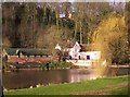
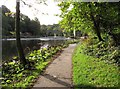
We walked up and down, then down and up, this lovely riverside path, directly underneath Durham Cathedral and the Castle, looking for St. Cuthbert's well. It is in a really lovely spot, although very close to the river, but as the signboard said, must have been prone to flooding.
Having read in the Portal entry that this museum contained examples of rock art, I was keen to visit, but the sign firmly said the museum was now closed. The University of Durham now have an on-line resource, but would love to go and pay a visit. At this time on a Sunday afternoon, it would have been closed, so a repeat visit will be necessary, but as it's such a beautiful location, and not far from home, this will not be too much of a hardship!
durhamnature visited - their rating: Cond: 4 Amb: 5 Access: 4 The ambience score should be 6, with its superb location below the cathedral in this world heritage site.
Average ratings for this site from all visit loggers: Condition: 3.5 Ambience: 4.5 Access: 4
")
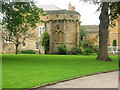
The Old Fulling Mill is now closed to visitors. (so not 'Destroyed' but marked as not open.) All exhibits have now been transferred to the University of Durham.
The University of Durham prehistory collection including some fine examples of rock art.
Address: The Banks, DH1 3EB
Phone: 0191 374 3623
Opening Hours: Friday-Monday 11.30 a.m. - 3.30 p.m. November-March, Daily 11 a.m. - 4 p.m. April-October
Admission: Small Charge
Visit their web site
You may be viewing yesterday's version of this page. To see the most up to date information please register for a free account.
")
")
Do not use the above information on other web sites or publications without permission of the contributor.
Nearby Images from Geograph Britain and Ireland:
©2006(licence)
©2008(licence)
©2011(licence)
©2018(licence)
©2011(licence)
The above images may not be of the site on this page, they are loaded from Geograph.
Please Submit an Image of this site or go out and take one for us!
Click here to see more info for this site
Nearby sites
Key: Red: member's photo, Blue: 3rd party photo, Yellow: other image, Green: no photo - please go there and take one, Grey: site destroyed
Download sites to:
KML (Google Earth)
GPX (GPS waypoints)
CSV (Garmin/Navman)
CSV (Excel)
To unlock full downloads you need to sign up as a Contributory Member. Otherwise downloads are limited to 50 sites.
Turn off the page maps and other distractions
Nearby sites listing. In the following links * = Image available
158m SW 236° St Mary's Well, Durham City* Holy Well or Sacred Spring (NZ27074191)
165m NNE 25° Galilee Well* Holy Well or Sacred Spring (NZ27274215)
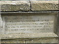
231m NNE 20° St Cuthbert's Well (County Durham)* Holy Well or Sacred Spring (NZ2727642218)
334m ESE 108° St. Oswald's Well* Holy Well or Sacred Spring (NZ27524190)
1.0km NW 313° Maiden's Bower (County Durham)* Round Cairn (NZ26434271)
1.1km ESE 106° Maiden Castle (Durham)* Promontory Fort / Cliff Castle (NZ283417)
4.4km NE 41° Woodwell House Ancient Village or Settlement (NZ30074531)
5.0km NW 313° Witton Hall Farm 1, 2, 3 & 4 Rock Art (NZ2349045400)
5.5km NW 309° White House Farm, Witton Gilbert 1 Rock Art (NZ2291045410)
6.1km NW 319° Fulforth Farm Stone 1 & 2 Rock Art (NZ2314046610)
6.2km NW 319° Fulforth Farm 3 Rock Art (NZ2310046600)
6.4km SW 228° St Brandon’s Church, Brancepeth* Carving (NZ22473769)
6.8km WSW 253° Brandon Hill Cist* Cist (NZ207400)
7.0km NNW 334° Waldridge Fell Barrow* Round Barrow(s) (NZ241483)
7.5km WSW 254° West Brandon Rock Art (NZ1995039900)
9.3km N 3° The Anker's House* Ancient Cross (NZ27575131)
9.9km NE 55° Fairies Cradle* Round Barrow(s) (NZ35374771)
10.5km NE 42° St Michael and All Angels (Houghton-le-Spring)* Burial Chamber or Dolmen (NZ342498)
10.6km NW 315° Holmside, Burnhope* Cairn (NZ196494)
10.8km NE 49° Copt Hill* Cairn (NZ353492)
11.3km N 4° North Lodge Cursus Cursus (NZ280533)
11.6km SSE 149° Bishop Middleham Cave Cave or Rock Shelter (NZ33223209)
11.6km SSE 167° Great Chilton Ancient Village or Settlement (NZ2995430684)
11.7km ENE 70° Croup Hill Barrows, Murton Round Barrow(s) (NZ382460)
11.8km ESE 112° Old Wingate Round Barrow* Round Barrow(s) (NZ3815937568)
View more nearby sites and additional images


 We would like to know more about this location. Please feel free to add a brief description and any relevant information in your own language.
 Wir möchten mehr über diese Stätte erfahren. Bitte zögern Sie nicht, eine kurze Beschreibung und relevante Informationen in Deutsch hinzuzufügen.
 Nous aimerions en savoir encore un peu sur les lieux. S'il vous plaît n'hesitez pas à ajouter une courte description et tous les renseignements pertinents dans votre propre langue.
 Quisieramos informarnos un poco más de las lugares. No dude en añadir una breve descripción y otros datos relevantes en su propio idioma.