

<< Text Pages >> Ghost Site Mounds - Artificial Mound in United States in The South
Submitted by bat400 on Friday, 06 May 2011 Page Views: 4414
Pre-ColumbianSite Name: Ghost Site MoundsCountry: United States Region: The South Type: Artificial Mound
Nearest Village: Newellton, LA
Latitude: 32.092916N Longitude: 91.450472W
Condition:
| 5 | Perfect |
| 4 | Almost Perfect |
| 3 | Reasonable but with some damage |
| 2 | Ruined but still recognisable as an ancient site |
| 1 | Pretty much destroyed, possibly visible as crop marks |
| 0 | No data. |
| -1 | Completely destroyed |
| 5 | Superb |
| 4 | Good |
| 3 | Ordinary |
| 2 | Not Good |
| 1 | Awful |
| 0 | No data. |
| 5 | Can be driven to, probably with disabled access |
| 4 | Short walk on a footpath |
| 3 | Requiring a bit more of a walk |
| 2 | A long walk |
| 1 | In the middle of nowhere, a nightmare to find |
| 0 | No data. |
| 5 | co-ordinates taken by GPS or official recorded co-ordinates |
| 4 | co-ordinates scaled from a detailed map |
| 3 | co-ordinates scaled from a bad map |
| 2 | co-ordinates of the nearest village |
| 1 | co-ordinates of the nearest town |
| 0 | no data |
Be the first person to rate this site - see the 'Contribute!' box in the right hand menu.
Internal Links:
External Links:
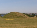
Artificial Mound in Tensas Parish, Louisiana.
The site is on private land, and normally without public access. However, the site can be viewed from the roadway, and there is a state historical marker. Reference: North East Louisiana Mound Trail Guide.
You may be viewing yesterday's version of this page. To see the most up to date information please register for a free account.
Do not use the above information on other web sites or publications without permission of the contributor.
Click here to see more info for this site
Nearby sites
Click here to view sites on an interactive map of the areaKey: Red: member's photo, Blue: 3rd party photo, Yellow: other image, Green: no photo - please go there and take one, Grey: site destroyed
Download sites to:
KML (Google Earth)
GPX (GPS waypoints)
CSV (Garmin/Navman)
CSV (Excel)
To unlock full downloads you need to sign up as a Contributory Member. Otherwise downloads are limited to 50 sites.
Turn off the page maps and other distractions
Nearby sites listing. In the following links * = Image available
14.9km SSE 159° Mayflower Mound Artificial Mound
15.5km ENE 65° Shackleford Church Mounds Artificial Mound
17.8km S 171° Sundown Mounds Artificial Mound
20.2km ENE 78° Balmoral Mounds* Artificial Mound
23.2km SE 140° Mound Plantation Artificial Mound
23.9km SE 135° Flowery Mound* Artificial Mound
32.9km N 355° Insley Mounds* Artificial Mound
34.6km ESE 118° Windsor Mounds* Artificial Mound
35.3km SSW 213° Peck Mounds Artificial Mound
38.5km NNE 12° Tendal Mound* Artificial Mound
41.0km SW 232° Boothe Landing Mound Artificial Mound
41.9km NE 35° Schicker Mound Artificial Mound
43.1km NE 54° Fitzhugh Mounds* Artificial Mound
43.7km ESE 106° Bayou Pierre Mounds* Artificial Mound
43.8km N 355° Marsden Mounds* Artificial Mound
44.8km SSW 205° Lamarque Landing Mound Artificial Mound
45.2km SSE 168° Anna Mound Complex* Artificial Mound
45.7km SW 229° Alexander Mound Artificial Mound
50.4km SSW 205° Cypress Grove Mound* Artificial Mound
50.6km SW 225° Harrisonburg Mounds Artificial Mound
50.8km ENE 72° Glass Mounds (Mississippi)* Artificial Mound
51.2km SW 223° McGuffee Mounds Ancient Village or Settlement
53.1km ESE 102° Mangum Mound* Artificial Mound
53.2km SSW 193° DePrato Mounds* Artificial Mound
53.7km W 268° Wade Landing Mound Artificial Mound
View more nearby sites and additional images


 We would like to know more about this location. Please feel free to add a brief description and any relevant information in your own language.
 Wir möchten mehr über diese Stätte erfahren. Bitte zögern Sie nicht, eine kurze Beschreibung und relevante Informationen in Deutsch hinzuzufügen.
 Nous aimerions en savoir encore un peu sur les lieux. S'il vous plaît n'hesitez pas à ajouter une courte description et tous les renseignements pertinents dans votre propre langue.
 Quisieramos informarnos un poco más de las lugares. No dude en añadir una breve descripción y otros datos relevantes en su propio idioma.