

<< Our Photo Pages >> Heidenstein (Schwörstadt) - Burial Chamber or Dolmen in Germany in Baden-Wuerttemberg
Submitted by AlexHunger on Tuesday, 13 September 2005 Page Views: 4094
Neolithic and Bronze AgeSite Name: Heidenstein (Schwörstadt)Country: Germany
NOTE: This site is 5.003 km away from the location you searched for.
Land: Baden-Wuerttemberg Type: Burial Chamber or Dolmen
Nearest Town: Basel Nearest Village: Schwörstadt
Latitude: 47.592487N Longitude: 7.871944E
Condition:
| 5 | Perfect |
| 4 | Almost Perfect |
| 3 | Reasonable but with some damage |
| 2 | Ruined but still recognisable as an ancient site |
| 1 | Pretty much destroyed, possibly visible as crop marks |
| 0 | No data. |
| -1 | Completely destroyed |
| 5 | Superb |
| 4 | Good |
| 3 | Ordinary |
| 2 | Not Good |
| 1 | Awful |
| 0 | No data. |
| 5 | Can be driven to, probably with disabled access |
| 4 | Short walk on a footpath |
| 3 | Requiring a bit more of a walk |
| 2 | A long walk |
| 1 | In the middle of nowhere, a nightmare to find |
| 0 | No data. |
| 5 | co-ordinates taken by GPS or official recorded co-ordinates |
| 4 | co-ordinates scaled from a detailed map |
| 3 | co-ordinates scaled from a bad map |
| 2 | co-ordinates of the nearest village |
| 1 | co-ordinates of the nearest town |
| 0 | no data |
Internal Links:
External Links:
I have visited· I would like to visit
aolson visited on 26th Dec 2020 - their rating: Cond: 2 Amb: 2 Access: 5 We first read the information panel, outlining the excavation and finds, and then on the "inside" of the dolmen we found some freshly laid flowers, which made the dry numbers or excavated skeletal remains in the information seem a little more human.
aolson visited on 6th Jul 2018 - their rating: Cond: 2 Amb: 2 Access: 5 Located along a residential street. Could have its own house number...
Average ratings for this site from all visit loggers: Condition: 2 Ambience: 2 Access: 5
 (PID:16512)")
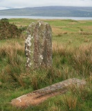
2.3 metre tall orthostat with porthole remaining of squarish dolmen. The three other limestone orthostats and cap stone have been lost, or re-used by local smith. Above the main road between the houses on the Römerstraße.
You may be viewing yesterday's version of this page. To see the most up to date information please register for a free account.
 (PID:16513)")
 (PID:221153)")
Do not use the above information on other web sites or publications without permission of the contributor.
Nearby Images from Flickr

The above images may not be of the site on this page, but were taken nearby. They are loaded from Flickr so please click on them for image credits.
Click here to see more info for this site
Nearby sites
Click here to view sites on an interactive map of the areaKey: Red: member's photo, Blue: 3rd party photo, Yellow: other image, Green: no photo - please go there and take one, Grey: site destroyed
Download sites to:
KML (Google Earth)
GPX (GPS waypoints)
CSV (Garmin/Navman)
CSV (Excel)
To unlock full downloads you need to sign up as a Contributory Member. Otherwise downloads are limited to 50 sites.
Turn off the page maps and other distractions
Nearby sites listing. In the following links * = Image available
2.3km N 3° Hunnenstein (Dossenbach)* Standing Stone (Menhir)
3.0km N 6° Der Stein Dossenbach* Standing Stone (Menhir)
6.0km SE 132° Menhir Bad Säckingen* Standing Stone (Menhir)
11.4km SSE 158° Schönauer Grenzsteine Standing Stone (Menhir)
11.4km SSE 158° Galgenstein (Wegenstetten) Chambered Tomb
13.0km WSW 240° Augusta Raurica* Ancient Village or Settlement
14.5km WNW 283° Homburger Wald Grabhügelgruppe Barrow Cemetery
15.9km WSW 255° Hornfels* Hillfort
16.0km W 277° Burghof Museum Museum
23.9km WNW 294° Katzenberg Grabhügelgruppe* Barrow Cemetery
25.8km E 82° Waldshut Heimatmuseum Museum
26.6km WSW 239° Aesch Dolmen* Chambered Tomb
27.0km S 175° Archaeological Museum of the Canton of Solothurn* Museum
27.1km WSW 243° Summstein Ettingen Modern Stone Circle etc
27.4km ENE 69° Langstein - Weilheim* Standing Stone (Menhir)
29.2km ESE 116° Windisch Schalenstein* Rock Art
30.6km E 83° Langenstein - Tiengen* Standing Stone (Menhir)
31.1km SW 223° Meltingen Schalenstein* Rock Art
32.8km NE 45° Schluchsee Steinkreise Stone Circle
32.8km SE 134° Goffersberg Gräberfelder Chambered Tomb
32.8km SE 134° Burghalde Museum Museum
33.3km SE 140° Niederholz Grabhügel* Artificial Mound
33.7km SW 236° Laufen Dolmen* Chambered Tomb
34.0km SE 141° Fornholz Grabhügel* Round Barrow(s)
35.1km SSW 200° Oensingen Schalenstein* Rock Art
View more nearby sites and additional images


 We would like to know more about this location. Please feel free to add a brief description and any relevant information in your own language.
 Wir möchten mehr über diese Stätte erfahren. Bitte zögern Sie nicht, eine kurze Beschreibung und relevante Informationen in Deutsch hinzuzufügen.
 Nous aimerions en savoir encore un peu sur les lieux. S'il vous plaît n'hesitez pas à ajouter une courte description et tous les renseignements pertinents dans votre propre langue.
 Quisieramos informarnos un poco más de las lugares. No dude en añadir una breve descripción y otros datos relevantes en su propio idioma.