


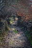
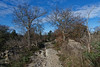
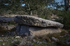
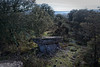
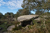
<< Our Photo Pages >> Dolmen de Banne 1 - Burial Chamber or Dolmen in France in Rhone:Ardèche (07)
Submitted by TheCaptain on Saturday, 16 April 2005 Page Views: 3002
Neolithic and Bronze AgeSite Name: Dolmen de Banne 1 Alternative Name: Sauts dolmenCountry: France Département: Rhone:Ardèche (07) Type: Burial Chamber or Dolmen
Nearest Town: Alès Nearest Village: Berrias
Latitude: 44.374560N Longitude: 4.170890E
Condition:
| 5 | Perfect |
| 4 | Almost Perfect |
| 3 | Reasonable but with some damage |
| 2 | Ruined but still recognisable as an ancient site |
| 1 | Pretty much destroyed, possibly visible as crop marks |
| 0 | No data. |
| -1 | Completely destroyed |
| 5 | Superb |
| 4 | Good |
| 3 | Ordinary |
| 2 | Not Good |
| 1 | Awful |
| 0 | No data. |
| 5 | Can be driven to, probably with disabled access |
| 4 | Short walk on a footpath |
| 3 | Requiring a bit more of a walk |
| 2 | A long walk |
| 1 | In the middle of nowhere, a nightmare to find |
| 0 | No data. |
| 5 | co-ordinates taken by GPS or official recorded co-ordinates |
| 4 | co-ordinates scaled from a detailed map |
| 3 | co-ordinates scaled from a bad map |
| 2 | co-ordinates of the nearest village |
| 1 | co-ordinates of the nearest town |
| 0 | no data |
Internal Links:
External Links:
I have visited· I would like to visit
johnstone visited on 1st Jul 2011 - their rating: Cond: 3 Amb: 3 Access: 4
")
You may be viewing yesterday's version of this page. To see the most up to date information please register for a free account.
")
")
Do not use the above information on other web sites or publications without permission of the contributor.
Nearby Images from Flickr
The above images may not be of the site on this page, but were taken nearby. They are loaded from Flickr so please click on them for image credits.
Click here to see more info for this site
Nearby sites
Click here to view sites on an interactive map of the areaKey: Red: member's photo, Blue: 3rd party photo, Yellow: other image, Green: no photo - please go there and take one, Grey: site destroyed
Download sites to:
KML (Google Earth)
GPX (GPS waypoints)
CSV (Garmin/Navman)
CSV (Excel)
To unlock full downloads you need to sign up as a Contributory Member. Otherwise downloads are limited to 50 sites.
Turn off the page maps and other distractions
Nearby sites listing. In the following links * = Image available
499m ENE 72° Dolmen de Banne 2* Burial Chamber or Dolmen
895m NE 37° Dolmen de Banne 5 Burial Chamber or Dolmen
919m ENE 71° Dolmen de Banne 3 Burial Chamber or Dolmen
1.0km NE 56° Dolmen de Banne 4 Burial Chamber or Dolmen
1.2km NE 49° Dolmen de Gélis 5 Burial Chamber or Dolmen
1.2km NE 48° Dolmen de Gélis 4 Burial Chamber or Dolmen
1.2km NE 45° Dolmen de Gélis 3 Burial Chamber or Dolmen
1.3km ENE 60° Dolmen de Gélis 1* Burial Chamber or Dolmen
1.6km SW 228° Banne menhir* Standing Stone (Menhir)
1.6km NW 310° Dolmen des Champs-Grands 8 Burial Chamber or Dolmen
1.7km WNW 297° Dolmen des Champs-Grands 7 Burial Chamber or Dolmen
1.8km WNW 291° Dolmen des Champs-Grands 5 Burial Chamber or Dolmen
2.0km WNW 284° Dolmen des Champs-Grands 2 Burial Chamber or Dolmen
2.0km WNW 286° Dolmen des Champs-Grands 4 Burial Chamber or Dolmen
2.0km WNW 284° Dolmen des Champs-Grands 1 Burial Chamber or Dolmen
2.0km WNW 284° Dolmen de Champs-Grands 3* Burial Chamber or Dolmen
2.1km WNW 288° Dolmen des Champs-Grands 6 Burial Chamber or Dolmen
2.3km NNW 346° Dolmen de la Combe de Mège* Burial Chamber or Dolmen
2.6km ENE 60° Dolmen des Granges (16) Burial Chamber or Dolmen
2.6km NE 41° Dolmen des Granges (17) Burial Chamber or Dolmen
2.6km ENE 63° Dolmen des Granges (15) Burial Chamber or Dolmen
2.7km ENE 59° Dolmen des Granges (21) Burial Chamber or Dolmen
2.9km ENE 65° Dolmen des Granges (14) Burial Chamber or Dolmen
2.9km W 265° Dolmen de Bannelle* Burial Chamber or Dolmen
2.9km NE 49° Dolmen des Granges (20) Burial Chamber or Dolmen
View more nearby sites and additional images


 We would like to know more about this location. Please feel free to add a brief description and any relevant information in your own language.
 Wir möchten mehr über diese Stätte erfahren. Bitte zögern Sie nicht, eine kurze Beschreibung und relevante Informationen in Deutsch hinzuzufügen.
 Nous aimerions en savoir encore un peu sur les lieux. S'il vous plaît n'hesitez pas à ajouter une courte description et tous les renseignements pertinents dans votre propre langue.
 Quisieramos informarnos un poco más de las lugares. No dude en añadir una breve descripción y otros datos relevantes en su propio idioma.