

<< Our Photo Pages >> Bagnol Dolmen - Burial Chamber or Dolmen in France in Limousin:Haute-Vienne (87)
Submitted by princessa on Wednesday, 14 May 2008 Page Views: 9393
Neolithic and Bronze AgeSite Name: Bagnol Dolmen Alternative Name: Dolmen de BagnolCountry: France Département: Limousin:Haute-Vienne (87) Type: Burial Chamber or Dolmen
Nearest Town: Guéret Nearest Village: Fromental
Latitude: 46.154900N Longitude: 1.433700E
Condition:
| 5 | Perfect |
| 4 | Almost Perfect |
| 3 | Reasonable but with some damage |
| 2 | Ruined but still recognisable as an ancient site |
| 1 | Pretty much destroyed, possibly visible as crop marks |
| 0 | No data. |
| -1 | Completely destroyed |
| 5 | Superb |
| 4 | Good |
| 3 | Ordinary |
| 2 | Not Good |
| 1 | Awful |
| 0 | No data. |
| 5 | Can be driven to, probably with disabled access |
| 4 | Short walk on a footpath |
| 3 | Requiring a bit more of a walk |
| 2 | A long walk |
| 1 | In the middle of nowhere, a nightmare to find |
| 0 | No data. |
| 5 | co-ordinates taken by GPS or official recorded co-ordinates |
| 4 | co-ordinates scaled from a detailed map |
| 3 | co-ordinates scaled from a bad map |
| 2 | co-ordinates of the nearest village |
| 1 | co-ordinates of the nearest town |
| 0 | no data |
Internal Links:
External Links:
I have visited· I would like to visit
DrewParsons would like to visit
J_W_R visited on 20th Aug 2022 - their rating: Cond: 4 Amb: 4 Access: 5
johnstone visited on 8th Sep 2014 - their rating: Cond: 3 Amb: 4 Access: 4
ModernExplorers visited on 5th May 2006 - their rating: Cond: 5 Access: 4
ModernExplorers visited on 30th Mar 2006 - their rating: Cond: 4 Amb: 3 Access: 4 Dolmen in a field in the middle of nowhere, I came across it while cycling through France
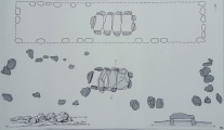
TheCaptain visited on 22nd Jul 2005 - their rating: Cond: 3 Amb: 4 Access: 4 Just beside the D.7 Road to the east of the station at Fromental is found this nice little dolmen, with a parking space and picnic area. The egg shaped capstone covers an oval chamber about 3 metres long and 2 metres wide. The pointed end points to the west, sitting on four slide slabs about 1.8 metres above the ground. It is open to both east and west ends.
Average ratings for this site from all visit loggers: Condition: 3.8 Ambience: 3.75 Access: 4.2
")
A dolmen is a type of megalithic tomb usually consisting of at least three upright megaliths which support a large horizontal stone. This gives the impression of a giant stone table. My children just loved making up stories about giant people using this giant table for eating little children... the ones who didn't do what their parents said!
For more information and photos on the Fromental area and the Dolmen of Bagnol, you can visit my hub page on the area.
Base Mérimée (Historic Monument)
You may be viewing yesterday's version of this page. To see the most up to date information please register for a free account.
")
")
")
")
")
")
")
")
")
")
")
")
")
")
")
Do not use the above information on other web sites or publications without permission of the contributor.
Click here to see more info for this site
Nearby sites
Click here to view sites on an interactive map of the areaKey: Red: member's photo, Blue: 3rd party photo, Yellow: other image, Green: no photo - please go there and take one, Grey: site destroyed
Download sites to:
KML (Google Earth)
GPX (GPS waypoints)
CSV (Garmin/Navman)
CSV (Excel)
To unlock full downloads you need to sign up as a Contributory Member. Otherwise downloads are limited to 50 sites.
Turn off the page maps and other distractions
Nearby sites listing. In the following links * = Image available
468m SSW 205° Menhir des Fichades* Standing Stone (Menhir)
1.5km WNW 282° Menhir de Chanliat Standing Stone (Menhir)
3.6km NNE 14° Menhir de la Faye Standing Stone (Menhir)
3.7km S 188° Dolmen de Goudour* Burial Chamber or Dolmen
4.7km S 171° Dolmen de Monteil Burial Chamber or Dolmen
4.7km SSE 156° Dolmen du Cluzeau* Burial Chamber or Dolmen
5.7km NNW 338° La Bachellerie Dolmen* Burial Chamber or Dolmen
6.3km E 101° Dolmen de Beauvais Burial Chamber or Dolmen
6.9km ENE 68° Dolmen de Chiroux* Burial Chamber or Dolmen
8.1km N 356° La Jarrige tumuli Chambered Tomb
8.9km NNE 28° Borne de la Gerafie dite Menhir* Marker Stone
9.7km ENE 75° Menhir de la Rebeyrolle* Standing Stone (Menhir)
10.0km NE 55° Pierre Folle de Saint-Priest-la-Feuille* Burial Chamber or Dolmen
10.3km ESE 112° Pierre des Trois Filles 1 Burial Chamber or Dolmen
10.3km ESE 112° Pierre des Trois Filles 2 Burial Chamber or Dolmen
10.3km ESE 112° Pierre des Trois Filles 3 Burial Chamber or Dolmen
11.4km ESE 111° Dolmen des Quatre Routes* Burial Chamber or Dolmen
11.8km ESE 108° Dolmen de Bois Neuf 3* Burial Chamber or Dolmen
11.8km ESE 108° Dolmen de Bois Neuf 2* Burial Chamber or Dolmen
12.6km NNW 331° Dolmen des Chirons Burial Chamber or Dolmen
12.9km WSW 253° Pierre de l'Etrade Natural Stone / Erratic / Other Natural Feature
12.9km NNW 343° Pierre Virdonaire Burial Chamber or Dolmen
13.6km SSE 163° Oppidum du Maillorat Ancient Village or Settlement
13.9km SSW 201° Motte féodale de l'Age* Ancient Village or Settlement
15.0km NNE 23° Dolmen de Peuplat Burial Chamber or Dolmen
View more nearby sites and additional images


 We would like to know more about this location. Please feel free to add a brief description and any relevant information in your own language.
 Wir möchten mehr über diese Stätte erfahren. Bitte zögern Sie nicht, eine kurze Beschreibung und relevante Informationen in Deutsch hinzuzufügen.
 Nous aimerions en savoir encore un peu sur les lieux. S'il vous plaît n'hesitez pas à ajouter une courte description et tous les renseignements pertinents dans votre propre langue.
 Quisieramos informarnos un poco más de las lugares. No dude en añadir una breve descripción y otros datos relevantes en su propio idioma.