 with our Megalithic Portal iPhone app")


<< Our Photo Pages >> Pierre Couverte de Bué - Burial Chamber or Dolmen in France in Centre:Indre (36)
Submitted by TheCaptain on Saturday, 16 April 2005 Page Views: 3747
Neolithic and Bronze AgeSite Name: Pierre Couverte de BuéCountry: France Département: Centre:Indre (36) Type: Burial Chamber or Dolmen
Nearest Town: Romorantin-Lanthenay Nearest Village: Bagneux
Latitude: 47.177700N Longitude: 1.770900E
Condition:
| 5 | Perfect |
| 4 | Almost Perfect |
| 3 | Reasonable but with some damage |
| 2 | Ruined but still recognisable as an ancient site |
| 1 | Pretty much destroyed, possibly visible as crop marks |
| 0 | No data. |
| -1 | Completely destroyed |
| 5 | Superb |
| 4 | Good |
| 3 | Ordinary |
| 2 | Not Good |
| 1 | Awful |
| 0 | No data. |
| 5 | Can be driven to, probably with disabled access |
| 4 | Short walk on a footpath |
| 3 | Requiring a bit more of a walk |
| 2 | A long walk |
| 1 | In the middle of nowhere, a nightmare to find |
| 0 | No data. |
| 5 | co-ordinates taken by GPS or official recorded co-ordinates |
| 4 | co-ordinates scaled from a detailed map |
| 3 | co-ordinates scaled from a bad map |
| 2 | co-ordinates of the nearest village |
| 1 | co-ordinates of the nearest town |
| 0 | no data |
Internal Links:
External Links:
I have visited· I would like to visit
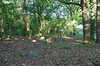
TheCaptain visited on 27th Sep 2005 - their rating: Cond: 4 Amb: 5 Access: 4 A couple of kilometres to the southeast of the village of Bagneux near to the hamlet of Bué, can be found this dolmen in a lovely situation in the forest. The dolmen is well signposted from all around, and from a parking place at Bué it is about 400 metres walk. The large capstone, 6m by 4m sits on top of a chamber 5m by 3m. It has a backstone and six sidestones in various positions of uprightness. The capstone is between 1 and 1.5 metres above the ground.
It has got its own bench nearby on which to sit and contemplate, with falling acorns a hazard, and a woodpecker pecking away amongst other things. This really is a lovely spot, and so gets a 5 for ambience.
I will make this my last megalithic site on my 6 months trip round France, it really is a nice place to finish on, and an unexpected dolmen at that.
It is now 2:30pm, and I really ought to be getting on driving back towards my sister's. Romorantin, Blois (roadworks), Vendome (Roadworks, big crane, school traffic), St-Calais (terrible traffic), Le Mans (rain, traffic jams), Alencon (slow traffic), Argentan, Flers (dug up, closed roads, diversions within diversions). It takes forever to find Vire, now in the complete dark, St-Lo (more diversions) and finally back to Sara's at about 9:30pm. I was amazed I didn't get tired or dozy at all while driving. Parked with 117630 km on the clock, 545 for today. Sausages and eggs (yummy), large beer, then to bed after seeing a depressing news on the telly. I've not missed missing all the bad news from around the world while away in my campervan.
")
The large capstone, 6m by 4m sits on top of a chamber 5m by 3m. It has a backstone and six sidestones in various positions of uprightness. The capstone is between 1 and 1.5 metres above the ground.
It has got its own bench nearby on which to sit and contemplate, with falling acorns a hazard, and a woodpecker pecking away amongst other things. This really is a lovely spot, and so gets a 5 for ambience.
IMPORTANT NOTE: Positional co-ordinates taken from a gps receiver.
You may be viewing yesterday's version of this page. To see the most up to date information please register for a free account.
")
")
")
")
Do not use the above information on other web sites or publications without permission of the contributor.
Nearby Images from Flickr
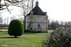


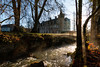
The above images may not be of the site on this page, but were taken nearby. They are loaded from Flickr so please click on them for image credits.
Click here to see more info for this site
Nearby sites
Click here to view sites on an interactive map of the areaKey: Red: member's photo, Blue: 3rd party photo, Yellow: other image, Green: no photo - please go there and take one, Grey: site destroyed
Download sites to:
KML (Google Earth)
GPX (GPS waypoints)
CSV (Garmin/Navman)
CSV (Excel)
To unlock full downloads you need to sign up as a Contributory Member. Otherwise downloads are limited to 50 sites.
Turn off the page maps and other distractions
Nearby sites listing. In the following links * = Image available
655m NNE 18° Pierre Levée de Boisy Standing Stone (Menhir)
819m SW 235° Tréfoux deux menhirs* Standing Stones
9.4km ESE 120° La Pierre Levée (Graçay)* Burial Chamber or Dolmen
13.9km SE 129° Dolmen de l'Ormeau Burial Chamber or Dolmen
15.6km SE 131° Dolmen de la Pierre-Folle (Le Creuset)* Burial Chamber or Dolmen
15.7km S 182° Liniez Tumulus elliptique Chambered Tomb
15.8km SSW 201° Dolmen des Pierres Folles (Bouges-le-Château) Burial Chamber or Dolmen
16.7km S 183° Pierre Levée (Liniez)* Passage Grave
18.3km WNW 302° Prieuré Saint Eusice dolmen Burial Chamber or Dolmen
20.2km N 355° Musée Archéologique Marcel de Marchéville Museum
23.6km WNW 298° Dolmen de Châtillon-sur-Cher Burial Chamber or Dolmen
24.2km SW 221° Les Chateliers Ancient Village or Settlement
26.6km SW 221° La Pierre cromlech Stone Circle
26.6km SW 221° La Pierre Dolmen* Burial Chamber or Dolmen
29.8km WNW 292° La Pierre-Frite de Grandmont Standing Stone (Menhir)
32.1km NW 325° Tertre tumulus Chambered Tomb
32.1km NW 325° Les Montanjons tumuli Chambered Tomb
36.6km N 349° les Châteliers Oppidum Ancient Village or Settlement
40.2km ESE 118° Dolmen dit la Table (Parneaux) Burial Chamber or Dolmen
42.8km SW 230° Saint-Genou Polissoir* Polissoir
43.8km NE 44° Coursangeon Tumulus Chambered Tomb
43.9km WNW 301° Dolmen dit de la Pierre de Minuit* Burial Chamber or Dolmen
46.0km NE 39° Falaze Tumulus Chambered Tomb
46.8km NE 38° Menhir du Champ de la Foire Standing Stone (Menhir)
46.9km NE 37° Pierrefitte Tumulus Chambered Tomb
View more nearby sites and additional images


 We would like to know more about this location. Please feel free to add a brief description and any relevant information in your own language.
 Wir möchten mehr über diese Stätte erfahren. Bitte zögern Sie nicht, eine kurze Beschreibung und relevante Informationen in Deutsch hinzuzufügen.
 Nous aimerions en savoir encore un peu sur les lieux. S'il vous plaît n'hesitez pas à ajouter une courte description et tous les renseignements pertinents dans votre propre langue.
 Quisieramos informarnos un poco más de las lugares. No dude en añadir una breve descripción y otros datos relevantes en su propio idioma.