

<< Our Photo Pages >> La Pierre-Folle allée couverte - Passage Grave in France in Poitou:Vienne (86)
Submitted by TheCaptain on Saturday, 16 April 2005 Page Views: 5068
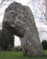
Neolithic and Bronze AgeSite Name: La Pierre-Folle allée couverteCountry: France Département: Poitou:Vienne (86) Type: Passage Grave
Nearest Town: Loudun Nearest Village: Bournand
Latitude: 47.110300N Longitude: 0.081400E
Condition:
| 5 | Perfect |
| 4 | Almost Perfect |
| 3 | Reasonable but with some damage |
| 2 | Ruined but still recognisable as an ancient site |
| 1 | Pretty much destroyed, possibly visible as crop marks |
| 0 | No data. |
| -1 | Completely destroyed |
| 5 | Superb |
| 4 | Good |
| 3 | Ordinary |
| 2 | Not Good |
| 1 | Awful |
| 0 | No data. |
| 5 | Can be driven to, probably with disabled access |
| 4 | Short walk on a footpath |
| 3 | Requiring a bit more of a walk |
| 2 | A long walk |
| 1 | In the middle of nowhere, a nightmare to find |
| 0 | No data. |
| 5 | co-ordinates taken by GPS or official recorded co-ordinates |
| 4 | co-ordinates scaled from a detailed map |
| 3 | co-ordinates scaled from a bad map |
| 2 | co-ordinates of the nearest village |
| 1 | co-ordinates of the nearest town |
| 0 | no data |
Internal Links:
External Links:
I have visited· I would like to visit
DrewParsons would like to visit
Rubis visited on 21st Sep 2010 - their rating: Cond: 5 Amb: 5 Access: 4 Wonderful! Marvellous! A jewel with the Renaissance farm as a case!
TheCaptain couldn't find on 17th Jul 2005 To the north of Bournand, but in a very vaguely marked place on my map, is marked the Pierre Folle allée couverte. In the village of Bournand, there is a sign pointing to the Pierre Folle, but as is often the case, there are no more signs later, and try as I might, without a detailed map I could not find this. After my failed visit, I found out that it is an 18 metre long allée couvert, on inaccessible private land within a Renaissance Lodge. It is said to be a superb megalithic monument.
")
From Rubis
Only opened for Les journées du patrimoine, this is what was sticked up at the entrance of the Farm.
It said that the allée couverte is 4000 years before J.C..
No bones were discovered during excavations. The entrance is oriented towards the sunset, during the winter solstice.
The main capstone pounds 130 tonnes. Celtic druids and pagans made ceremonies around it. Il all stopped in the sixth century when Saint Martin came there.
You may be viewing yesterday's version of this page. To see the most up to date information please register for a free account.
")
")
")
")
")
")
")
")
")
")
")
")
")
")
")
Do not use the above information on other web sites or publications without permission of the contributor.
Click here to see more info for this site
Nearby sites
Click here to view sites on an interactive map of the areaKey: Red: member's photo, Blue: 3rd party photo, Yellow: other image, Green: no photo - please go there and take one, Grey: site destroyed
Download sites to:
KML (Google Earth)
GPX (GPS waypoints)
CSV (Garmin/Navman)
CSV (Excel)
To unlock full downloads you need to sign up as a Contributory Member. Otherwise downloads are limited to 50 sites.
Turn off the page maps and other distractions
Nearby sites listing. In the following links * = Image available
6.0km S 169° Dolmen d'Epennes* Burial Chamber or Dolmen
7.1km SW 221° Trois-Moutiers dolmen Burial Chamber or Dolmen
7.6km NE 34° La Pierre Couverte (Thizay)* Burial Chamber or Dolmen
8.1km SW 228° Vaon Dolmen* Burial Chamber or Dolmen
8.1km SW 217° La Pierre Crapaud* Burial Chamber or Dolmen
8.2km NE 56° Camp de Cinais Ancient Village or Settlement
8.2km ENE 58° Camp de Cinais Alignement Stone Row / Alignment
8.3km SW 215° Menhir de la Porte Rouge* Standing Stone (Menhir)
8.3km SW 214° Dolmen de la Porte Rouge* Burial Chamber or Dolmen
8.3km SW 220° Dolmen de la Rente de Fontevrault* Burial Chamber or Dolmen
8.4km SSW 211° Dolmen du Tertre des Fées* Burial Chamber or Dolmen
8.7km WSW 250° Dolmen de la Fontaine au Son 2* Burial Chamber or Dolmen
8.8km WSW 250° Dolmen de la Fontaine au Son 1* Burial Chamber or Dolmen
8.9km SSW 205° La Roche Vernaise* Burial Chamber or Dolmen
10.0km W 267° Les Dormants Dolmen Burial Chamber or Dolmen
10.1km NE 41° Dolmen de la Grosse Pierre (Beaumont-en-Véron) Burial Chamber or Dolmen
10.9km NNW 345° Dolmen de la Pierrelée* Burial Chamber or Dolmen
11.3km SW 232° La Pierre-Levée-de-Courçu Standing Stone (Menhir)
12.9km W 266° Grande Pierre Levée de la Daviere Standing Stone (Menhir)
12.9km S 187° Dolmen de Lassay Burial Chamber or Dolmen
13.8km S 174° Dolmen de Nouzilly Burial Chamber or Dolmen
14.1km NNW 339° Alignement de Targé Stone Row / Alignment
14.5km E 88° Le Carroir Bon-Air* Burial Chamber or Dolmen
16.2km NW 311° Tombe de La Gresille Burial Chamber or Dolmen
16.5km W 273° l'Accomodement Menhir* Standing Stone (Menhir)
View more nearby sites and additional images


 We would like to know more about this location. Please feel free to add a brief description and any relevant information in your own language.
 Wir möchten mehr über diese Stätte erfahren. Bitte zögern Sie nicht, eine kurze Beschreibung und relevante Informationen in Deutsch hinzuzufügen.
 Nous aimerions en savoir encore un peu sur les lieux. S'il vous plaît n'hesitez pas à ajouter une courte description et tous les renseignements pertinents dans votre propre langue.
 Quisieramos informarnos un poco más de las lugares. No dude en añadir una breve descripción y otros datos relevantes en su propio idioma.