

<< Our Photo Pages >> La Tardivière - Passage Grave in France in Pays de la Loire:Mayenne (53)
Submitted by TheCaptain on Saturday, 16 April 2005 Page Views: 3861
Neolithic and Bronze AgeSite Name: La TardivièreCountry: France Département: Pays de la Loire:Mayenne (53) Type: Passage Grave
Nearest Town: Ernée Nearest Village: Ernée
Latitude: 48.328800N Longitude: 0.9142W
Condition:
| 5 | Perfect |
| 4 | Almost Perfect |
| 3 | Reasonable but with some damage |
| 2 | Ruined but still recognisable as an ancient site |
| 1 | Pretty much destroyed, possibly visible as crop marks |
| 0 | No data. |
| -1 | Completely destroyed |
| 5 | Superb |
| 4 | Good |
| 3 | Ordinary |
| 2 | Not Good |
| 1 | Awful |
| 0 | No data. |
| 5 | Can be driven to, probably with disabled access |
| 4 | Short walk on a footpath |
| 3 | Requiring a bit more of a walk |
| 2 | A long walk |
| 1 | In the middle of nowhere, a nightmare to find |
| 0 | No data. |
| 5 | co-ordinates taken by GPS or official recorded co-ordinates |
| 4 | co-ordinates scaled from a detailed map |
| 3 | co-ordinates scaled from a bad map |
| 2 | co-ordinates of the nearest village |
| 1 | co-ordinates of the nearest town |
| 0 | no data |
Internal Links:
External Links:
I have visited· I would like to visit
thereddragon visited on 6th Apr 2014 - their rating: Cond: 2 Amb: 3 Access: 4 The field had been recently ploughed so I jumped over the fence for some close ups.
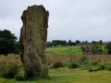
TheCaptain visited on 29th Apr 2005 - their rating: Cond: 3 Amb: 3 Access: 4 Another little Mayenne allée couverte about 6 or 7 metres in length facing uphill and eastwards. It is in fairly ruinous condition with only one capstone remaining at the top end of about 8 pairs of upright stones. There is a large end stone at the lower western end.
It is found in open rolling countryside marked on my ign map but not signposted. At the time of my visit it was in an open field about a hundred metres down the farm track from the country lane where I parked. About 30 metres down from the dolmen was a fairly large stone at the side of the farmtrack. Possibly a marker stone for the tomb but I suspect more likely one of the stones from the allée couverte moved away and dumped at some point.
Average ratings for this site from all visit loggers: Condition: 2.5 Ambience: 3 Access: 4
")
It is found in open rolling countryside, marked on my ign map but not signposted. At the time of my visit it was in an open field, about a hundred metres down the farm track from the country lane where I parked.
About 30 metres down from the dolmen was a fairly large stone at the side of the farmtrack. Possibly a marker stone for the tomb, but I suspect more likely one of the stones from the allée couvert, moved away and dumped at some point.
IMPORTANT NOTE: Position of site taken from gps reciever
You may be viewing yesterday's version of this page. To see the most up to date information please register for a free account.
")
")
")
")
")
")
")
")
")
")
")
")
Do not use the above information on other web sites or publications without permission of the contributor.
Click here to see more info for this site
Nearby sites
Click here to view sites on an interactive map of the areaKey: Red: member's photo, Blue: 3rd party photo, Yellow: other image, Green: no photo - please go there and take one, Grey: site destroyed
Download sites to:
KML (Google Earth)
GPX (GPS waypoints)
CSV (Garmin/Navman)
CSV (Excel)
To unlock full downloads you need to sign up as a Contributory Member. Otherwise downloads are limited to 50 sites.
Turn off the page maps and other distractions
Nearby sites listing. In the following links * = Image available
1.5km W 263° La Contrie du Rocher* Burial Chamber or Dolmen
1.9km WSW 240° Menhir de la Blanchardière Standing Stone (Menhir)
5.2km NW 324° Broussardière Menhir* Standing Stone (Menhir)
6.0km W 266° Allée Couverte du Bois de Broussault* Passage Grave
6.6km SE 139° La Berthellière* Polissoir
8.7km SE 138° Allée Couverte de la Perche Passage Grave
9.4km ESE 115° Dolmen de la Crête* Passage Grave
9.5km NE 52° Stèle de Brécé B Standing Stone (Menhir)
9.5km NE 52° Stèle de Brécé A Standing Stone (Menhir)
10.4km NNE 24° Dolmen de la Pierre (Hercé)* Burial Chamber or Dolmen
11.2km NNW 338° La Hutte-aux-Gabelous* Passage Grave
12.0km NE 43° Menhir de la Roche (Gorron)* Standing Stone (Menhir)
12.5km ENE 74° Allée couverte du Rocher Passage Grave
12.5km ENE 73° Menhir de la Chaire* Standing Stone (Menhir)
12.6km E 88° La Croix de la Fizellerie* Standing Stone (Menhir)
12.8km ESE 107° Allée couverte de Baillée Passage Grave
12.8km E 79° Allée Couverte de la Grande-Burlaie Passage Grave
12.8km ENE 68° Petit-Vieux-Sou* Passage Grave
13.6km ENE 73° l’Allée couverte de la Gasnerie Passage Grave
14.0km SSE 164° Clivay Menhir* Standing Stone (Menhir)
14.8km NE 49° La Pierre Saint-Guillaume Standing Stone (Menhir)
15.9km NNE 13° Désertines Menhir* Standing Stone (Menhir)
16.0km E 85° Menhir de la Chablère* Standing Stone (Menhir)
17.3km SE 143° Menhir du Faix du Diable* Standing Stone (Menhir)
17.6km ENE 59° Menhir dit la Pierre Saint-Siviard* Standing Stone (Menhir)
View more nearby sites and additional images


 We would like to know more about this location. Please feel free to add a brief description and any relevant information in your own language.
 Wir möchten mehr über diese Stätte erfahren. Bitte zögern Sie nicht, eine kurze Beschreibung und relevante Informationen in Deutsch hinzuzufügen.
 Nous aimerions en savoir encore un peu sur les lieux. S'il vous plaît n'hesitez pas à ajouter une courte description et tous les renseignements pertinents dans votre propre langue.
 Quisieramos informarnos un poco más de las lugares. No dude en añadir una breve descripción y otros datos relevantes en su propio idioma.