


<< Our Photo Pages >> Sharpitor W Terminal Cairn - Cairn in England in Devon
Submitted by Anne T on Tuesday, 05 November 2019 Page Views: 636
Neolithic and Bronze AgeSite Name: Sharpitor W Terminal Cairn Alternative Name: Peek Hill Cairn Circle; Grinsell Walkhampton 18Country: England County: Devon Type: Cairn
Nearest Town: Yelverton / Princetown Nearest Village: Walkhampton / Dousland
Map Ref: SX5505670751
Latitude: 50.518549N Longitude: 4.045919W
Condition:
| 5 | Perfect |
| 4 | Almost Perfect |
| 3 | Reasonable but with some damage |
| 2 | Ruined but still recognisable as an ancient site |
| 1 | Pretty much destroyed, possibly visible as crop marks |
| 0 | No data. |
| -1 | Completely destroyed |
| 5 | Superb |
| 4 | Good |
| 3 | Ordinary |
| 2 | Not Good |
| 1 | Awful |
| 0 | No data. |
| 5 | Can be driven to, probably with disabled access |
| 4 | Short walk on a footpath |
| 3 | Requiring a bit more of a walk |
| 2 | A long walk |
| 1 | In the middle of nowhere, a nightmare to find |
| 0 | No data. |
| 5 | co-ordinates taken by GPS or official recorded co-ordinates |
| 4 | co-ordinates scaled from a detailed map |
| 3 | co-ordinates scaled from a bad map |
| 2 | co-ordinates of the nearest village |
| 1 | co-ordinates of the nearest town |
| 0 | no data |
Be the first person to rate this site - see the 'Contribute!' box in the right hand menu.
Internal Links:
External Links:
")
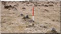
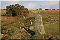
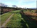
This is the terminal cairn of the Sharpitor West single stone row, details of which come from the Stone Rows of Britain website - see their entry for Sharpitor, West, which includes a plan of the row showing this cairn at its north eastern terminal and a tall pillar stone at its other end.
The cairn is also featured on the Prehistoric Dartmoor Walks (PDW) website - see their entries for the Sharpitor W. (Peek Hill) Cairn Circle and the Sharpitor area Stone Rows and Cists. PDW tells us that: "The cairn lies on a gentle SW slope NE of Horseyeatt farm, with a stone row see running SW from it. The cairn is about 7m in diameter and 0.6m height, partly turf-covered, with a central hollow. The visible set stones within the cairn suggest two or three underlying concentric stone circles".
The cairn is also recorded as Pastscape Monument NO. 440234, as MDV5011 (Cairn at north-eastern end of a stone row north-east of Horseyeatt) on the Devon and Dartmoor HER and scheduled as part of Historic England List Entry No. 1019566 (Stone alignment, five cairns, two stone hut circles and a length of reave 600m north east of Horseyeatt).
You may be viewing yesterday's version of this page. To see the most up to date information please register for a free account.
Do not use the above information on other web sites or publications without permission of the contributor.
Nearby Images from Geograph Britain and Ireland:
©2020(licence)
©2009(licence)
©2015(licence)
©2010(licence)
©2007(licence)
The above images may not be of the site on this page, they are loaded from Geograph.
Please Submit an Image of this site or go out and take one for us!
Click here to see more info for this site
Nearby sites
Key: Red: member's photo, Blue: 3rd party photo, Yellow: other image, Green: no photo - please go there and take one, Grey: site destroyed
Download sites to:
KML (Google Earth)
GPX (GPS waypoints)
CSV (Garmin/Navman)
CSV (Excel)
To unlock full downloads you need to sign up as a Contributory Member. Otherwise downloads are limited to 50 sites.
Turn off the page maps and other distractions
Nearby sites listing. In the following links * = Image available
4m SE 144° Sharpitor W* Stone Row / Alignment (SX5505870748)
622m E 101° Sharpitor NW double row* Multiple Stone Rows / Avenue (SX5566570617)
631m ESE 102° Sharpitor NW single row* Stone Row / Alignment (SX5567170601)
783m E 94° Sharpitor cairn circle* Cairn (SX5583870678)
988m N 10° Routrundle South* Ancient Village or Settlement (SX55257172)
1.1km E 87° Sharpitor NE* Multiple Stone Rows / Avenue (SX5613670785)
1.1km ENE 59° Leeden Hill* Standing Stone (Menhir) (SX56017128)
1.1km NNE 15° Routrundle North* Ancient Village or Settlement (SX55387185)
1.3km E 86° Sharpitor NE (2) Stone Row / Alignment (SX564708)
1.4km E 84° Stanlake Cist* Cist (SX5641670852)
1.6km NNE 30° Ingra Tor Cist* Cairn (SX5587272083)
1.6km ENE 62° Leeden Tor* Stone Row / Alignment (SX5652271474)
1.8km SE 133° Leather Tor* Cist (SX5631869522)
1.9km ESE 103° Stan Lake Platform Cairn Circle Cairn (SX56917028)
2.0km ENE 71° Black Tor Stone Row Cairns (Stanlake)* Cairn (SX5699071370)
2.0km ENE 77° Stanlake Settlement* Ancient Village or Settlement (SX57057115)
2.2km ENE 69° Black Tor (Meavy)* Multiple Stone Rows / Avenue (SX5710271463)
2.3km WNW 293° Sampford Spiney Memorial Stone Early Christian Sculptured Stone (SX52987168)
2.4km NW 315° Sampford Spiney Church* Standing Stones (SX53427246)
2.7km ENE 73° Raddick Hill North* Ancient Village or Settlement (SX57657147)
2.7km NE 37° Walkhampton Enclosed Settlement* Ancient Village or Settlement (SX56747286)
2.7km ENE 68° Hart Tor north rows* Multiple Stone Rows / Avenue (SX57637169)
2.8km ENE 69° Hart Tor south row* Stone Row / Alignment (SX57687168)
2.8km ENE 69° Hart Tor North circle* Stone Circle (SX57717171)
2.8km ENE 69° Hart Tor South Terminal Cairn* Cairn (SX57727170)
View more nearby sites and additional images


 We would like to know more about this location. Please feel free to add a brief description and any relevant information in your own language.
 Wir möchten mehr über diese Stätte erfahren. Bitte zögern Sie nicht, eine kurze Beschreibung und relevante Informationen in Deutsch hinzuzufügen.
 Nous aimerions en savoir encore un peu sur les lieux. S'il vous plaît n'hesitez pas à ajouter une courte description et tous les renseignements pertinents dans votre propre langue.
 Quisieramos informarnos un poco más de las lugares. No dude en añadir una breve descripción y otros datos relevantes en su propio idioma.