 with our Megalithic Portal iPhone app")

<< Our Photo Pages >> Menhirs le Vieux-Moulin (N) - Stone Row / Alignment in France in Bretagne:Morbihan (56)
Submitted by TheCaptain on Monday, 21 January 2019 Page Views: 811
Neolithic and Bronze AgeSite Name: Menhirs le Vieux-Moulin (N)Country: France Département: Bretagne:Morbihan (56) Type: Stone Row / Alignment
Nearest Town: Carnac Nearest Village: Plouharnel
Latitude: 47.607100N Longitude: 3.1196W
Condition:
| 5 | Perfect |
| 4 | Almost Perfect |
| 3 | Reasonable but with some damage |
| 2 | Ruined but still recognisable as an ancient site |
| 1 | Pretty much destroyed, possibly visible as crop marks |
| 0 | No data. |
| -1 | Completely destroyed |
| 5 | Superb |
| 4 | Good |
| 3 | Ordinary |
| 2 | Not Good |
| 1 | Awful |
| 0 | No data. |
| 5 | Can be driven to, probably with disabled access |
| 4 | Short walk on a footpath |
| 3 | Requiring a bit more of a walk |
| 2 | A long walk |
| 1 | In the middle of nowhere, a nightmare to find |
| 0 | No data. |
| 5 | co-ordinates taken by GPS or official recorded co-ordinates |
| 4 | co-ordinates scaled from a detailed map |
| 3 | co-ordinates scaled from a bad map |
| 2 | co-ordinates of the nearest village |
| 1 | co-ordinates of the nearest town |
| 0 | no data |
Be the first person to rate this site - see the 'Contribute!' box in the right hand menu.
Internal Links:
External Links:
I have visited· I would like to visit
Catrinm visited on 13th Sep 2022 - their rating: Cond: 3 Amb: 4 Access: 4 Still awesomely large
aolson visited on 17th Jul 2020 - their rating: Cond: 4 Amb: 4 Access: 3
Ogham have visited here
Average ratings for this site from all visit loggers: Condition: 3.5 Ambience: 4 Access: 3.5
 (PID:91088)")
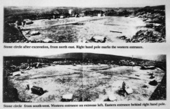
Three large blocks of which one is fallen. Were these once part of the same construction as their neighbours to the south?
Two of the stones have engravings
You may be viewing yesterday's version of this page. To see the most up to date information please register for a free account.
 (PID:79175)")
 (PID:79174)")
 (PID:79172)")
 (PID:79176)")
 (PID:125009)")
 (PID:79171)")
 (PID:125016)")
 (PID:91089)")
 (PID:79173)")
Do not use the above information on other web sites or publications without permission of the contributor.
Click here to see more info for this site
Nearby sites
Click here to view sites on an interactive map of the areaKey: Red: member's photo, Blue: 3rd party photo, Yellow: other image, Green: no photo - please go there and take one, Grey: site destroyed
Download sites to:
KML (Google Earth)
GPX (GPS waypoints)
CSV (Garmin/Navman)
CSV (Excel)
To unlock full downloads you need to sign up as a Contributory Member. Otherwise downloads are limited to 50 sites.
Turn off the page maps and other distractions
Nearby sites listing. In the following links * = Image available
91m S 177° Vieux-Moulin Alignement* Stone Row / Alignment
736m SSE 165° Rondossec Dolmens* Burial Chamber or Dolmen
823m N 4° Dolmens de Mane Rumor* Burial Chamber or Dolmen
1.0km W 280° Sainte-Barbe alignement* Multiple Stone Rows / Avenue
1.1km SSE 152° Carnac Discovery Centre* Museum
1.1km NNW 343° Dolmen de Kernevé* Burial Chamber or Dolmen
1.3km NNW 329° Tennad-er-Menguen Dolmen* Burial Chamber or Dolmen
1.5km SE 142° Kergavat Dolmen* Burial Chamber or Dolmen
1.6km E 83° Runesto Dolmen* Burial Chamber or Dolmen
1.7km SE 140° Dolmen de Plouharnel 2 Burial Chamber or Dolmen
1.8km NE 52° Dolmen de Cosquer Mané er Roh Burial Chamber or Dolmen
1.9km N 355° Crucuno Cromlech* Stone Circle
1.9km SE 136° Menhir de Bihor Standing Stone (Menhir)
2.0km NNW 345° Crucuno Dolmen* Burial Chamber or Dolmen
2.0km NE 41° Dolmen de Cosquer Er Mané* Burial Chamber or Dolmen
2.1km E 83° Menhir des Bruyères Standing Stone (Menhir)
2.2km ENE 58° Alignement de Crucuny Stone Row / Alignment
2.2km ENE 78° Dolmens de Kerogel Burial Chamber or Dolmen
2.2km N 9° Menhir de Bovelann Standing Stone (Menhir)
2.4km N 359° Mané-Groh Dolmen* Burial Chamber or Dolmen
2.4km SSE 152° Kerroc’h cromlech* Stone Circle
2.4km SSE 153° Kerroc'h Dolmen* Burial Chamber or Dolmen
2.4km ENE 71° Dolmen de Gognel Burial Chamber or Dolmen
2.5km SE 125° Menhirs de Kerderff* Standing Stones
2.6km NNE 24° Coffre de Lannec Parqueu Hir er Neur Burial Chamber or Dolmen
View more nearby sites and additional images


 We would like to know more about this location. Please feel free to add a brief description and any relevant information in your own language.
 Wir möchten mehr über diese Stätte erfahren. Bitte zögern Sie nicht, eine kurze Beschreibung und relevante Informationen in Deutsch hinzuzufügen.
 Nous aimerions en savoir encore un peu sur les lieux. S'il vous plaît n'hesitez pas à ajouter une courte description et tous les renseignements pertinents dans votre propre langue.
 Quisieramos informarnos un poco más de las lugares. No dude en añadir una breve descripción y otros datos relevantes en su propio idioma.